Maps of Islington

Insurance Plan of London Vol. XI: sheet 308-1
1 : 960 This detailed 1890 plan of London is one of a series of thirty-one sheets in an atlas originally produced to aid insurance companies in assessing fire risks. The building footprints, their use (commercial, residential, educational, etc.), the number of floors and the height of the building, as well as construction materials (and thus risk of burning) and special fire hazards (chemicals, kilns, ovens) were documented in order to estimate premiums. Names of individual businesses, property lines, and addresses were also often recorded. Together these maps provide a rich historical shapshot of the commercial activity and urban landscape of towns and cities at the time. The British Library holds a comprehensive collection of fire insurance plans produced by the London-based firm Charles E. Goad Ltd. dating back to 1885. These plans were made for most important towns and cities of the British Isles at the scales of 1:480 (1 inch to 40 feet), as well as many foreign towns at 1:600 (1 inch to 50 feet). Chas E Goad Limited Chas E Goad Limited
Insurance Plan of London Vol. XI: sheet 308-2
1 : 960 This detailed 1890 plan of London is one of a series of thirty-one sheets in an atlas originally produced to aid insurance companies in assessing fire risks. The building footprints, their use (commercial, residential, educational, etc.), the number of floors and the height of the building, as well as construction materials (and thus risk of burning) and special fire hazards (chemicals, kilns, ovens) were documented in order to estimate premiums. Names of individual businesses, property lines, and addresses were also often recorded. Together these maps provide a rich historical shapshot of the commercial activity and urban landscape of towns and cities at the time. The British Library holds a comprehensive collection of fire insurance plans produced by the London-based firm Charles E. Goad Ltd. dating back to 1885. These plans were made for most important towns and cities of the British Isles at the scales of 1:480 (1 inch to 40 feet), as well as many foreign towns at 1:600 (1 inch to 50 feet). Chas E Goad Limited Chas E Goad Limited
Insurance Plan of London Vol. XI: sheet 308-3
1 : 960 This detailed 1890 plan of London is one of a series of thirty-one sheets in an atlas originally produced to aid insurance companies in assessing fire risks. The building footprints, their use (commercial, residential, educational, etc.), the number of floors and the height of the building, as well as construction materials (and thus risk of burning) and special fire hazards (chemicals, kilns, ovens) were documented in order to estimate premiums. Names of individual businesses, property lines, and addresses were also often recorded. Together these maps provide a rich historical shapshot of the commercial activity and urban landscape of towns and cities at the time. The British Library holds a comprehensive collection of fire insurance plans produced by the London-based firm Charles E. Goad Ltd. dating back to 1885. These plans were made for most important towns and cities of the British Isles at the scales of 1:480 (1 inch to 40 feet), as well as many foreign towns at 1:600 (1 inch to 50 feet). Chas E Goad Limited Chas E Goad Limited
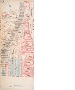
Insurance Plan of London Vol. XI: sheet 308-4
1 : 960 This detailed 1890 plan of London is one of a series of thirty-one sheets in an atlas originally produced to aid insurance companies in assessing fire risks. The building footprints, their use (commercial, residential, educational, etc.), the number of floors and the height of the building, as well as construction materials (and thus risk of burning) and special fire hazards (chemicals, kilns, ovens) were documented in order to estimate premiums. Names of individual businesses, property lines, and addresses were also often recorded. Together these maps provide a rich historical shapshot of the commercial activity and urban landscape of towns and cities at the time. The British Library holds a comprehensive collection of fire insurance plans produced by the London-based firm Charles E. Goad Ltd. dating back to 1885. These plans were made for most important towns and cities of the British Isles at the scales of 1:480 (1 inch to 40 feet), as well as many foreign towns at 1:600 (1 inch to 50 feet). Chas E Goad Limited Chas E Goad Limited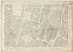
London VII.56 - OS London Town Plan
1 : 1056 Topographic maps Ordnance Survey Ordnance Survey
Insurance Plan of London Vol. XI: sheet 311
1 : 480 This detailed 1890 plan of London is one of a series of thirty-one sheets in an atlas originally produced to aid insurance companies in assessing fire risks. The building footprints, their use (commercial, residential, educational, etc.), the number of floors and the height of the building, as well as construction materials (and thus risk of burning) and special fire hazards (chemicals, kilns, ovens) were documented in order to estimate premiums. Names of individual businesses, property lines, and addresses were also often recorded. Together these maps provide a rich historical shapshot of the commercial activity and urban landscape of towns and cities at the time. The British Library holds a comprehensive collection of fire insurance plans produced by the London-based firm Charles E. Goad Ltd. dating back to 1885. These plans were made for most important towns and cities of the British Isles at the scales of 1:480 (1 inch to 40 feet), as well as many foreign towns at 1:600 (1 inch to 50 feet). Chas E Goad Limited Chas E Goad Limited
Insurance Plan of London Vol. XI: sheet 309
1 : 480 This detailed 1890 plan of London is one of a series of thirty-one sheets in an atlas originally produced to aid insurance companies in assessing fire risks. The building footprints, their use (commercial, residential, educational, etc.), the number of floors and the height of the building, as well as construction materials (and thus risk of burning) and special fire hazards (chemicals, kilns, ovens) were documented in order to estimate premiums. Names of individual businesses, property lines, and addresses were also often recorded. Together these maps provide a rich historical shapshot of the commercial activity and urban landscape of towns and cities at the time. The British Library holds a comprehensive collection of fire insurance plans produced by the London-based firm Charles E. Goad Ltd. dating back to 1885. These plans were made for most important towns and cities of the British Isles at the scales of 1:480 (1 inch to 40 feet), as well as many foreign towns at 1:600 (1 inch to 50 feet). Chas E Goad Limited Chas E Goad Limited
Insurance Plan of London Vol. VI: sheet 143
1 : 480 This detailed 1887 plan of London is one of a series of twenty-seven sheets in an atlas originally produced to aid insurance companies in assessing fire risks. The building footprints, their use (commercial, residential, educational, etc.), the number of floors and the height of the building, as well as construction materials (and thus risk of burning) and special fire hazards (chemicals, kilns, ovens) were documented in order to estimate premiums. Names of individual businesses, property lines, and addresses were also often recorded. Together these maps provide a rich historical shapshot of the commercial activity and urban landscape of towns and cities at the time. The British Library holds a comprehensive collection of fire insurance plans produced by the London-based firm Charles E. Goad Ltd. dating back to 1885. These plans were made for most important towns and cities of the British Isles at the scales of 1:480 (1 inch to 40 feet), as well as many foreign towns at 1:600 (1 inch to 50 feet). Chas E Goad Limited Chas E Goad Limited
Insurance Plan of London Vol. VI: sheet 149
1 : 480 This detailed 1887 plan of London is one of a series of twenty-seven sheets in an atlas originally produced to aid insurance companies in assessing fire risks. The building footprints, their use (commercial, residential, educational, etc.), the number of floors and the height of the building, as well as construction materials (and thus risk of burning) and special fire hazards (chemicals, kilns, ovens) were documented in order to estimate premiums. Names of individual businesses, property lines, and addresses were also often recorded. Together these maps provide a rich historical shapshot of the commercial activity and urban landscape of towns and cities at the time. The British Library holds a comprehensive collection of fire insurance plans produced by the London-based firm Charles E. Goad Ltd. dating back to 1885. These plans were made for most important towns and cities of the British Isles at the scales of 1:480 (1 inch to 40 feet), as well as many foreign towns at 1:600 (1 inch to 50 feet). Chas E Goad Limited Chas E Goad Limited
An Actual Survey of the Parish of St. Leonard in Shoreditch, Middlesex, taken in the Year 1745 by Peter Chassereau. 5
Survey of the roads from Old Street Church to Shoreditch Church with both churches shown pictorially, scale bar at lower right, orientation points marked on margins and key to distances between junctions in table at middle left.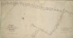
Plan of the Highways held under the Trustees of the OLD STREET TURNPIKE ROADS in the County of Middlesex
Survey of the streets in the Old Street Turnpike Roads Trust, London, from Goswell Street to Hackney Road with title and scale bar at lower left, compass in the centre and key to distances between junctions in table at bottom right. Wickings, W.
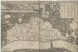
SCHOREDITCH, NORTON FALGATE and CRIPPLEGATE WITHOUT. Taken From y.e last Survey With Corrections 3A
1 : 4800 Plan of Shoreditch in the City of London, published in Strype's first annotated edition of Stow's 'Survey of England'. The plan features title in cartouche at the top of the plate, scale bar and compass at bottom left and key to streets, yards, squares, churches and public buildings in tables at top left and lower right. A dotted line marks the boundary between the parish of St. Leonard Shoreditch and St. Giles Cripple Gate. Hoxton Square, where the development of Shoreditch began in the 1680's is indicated at top right. Blome, Richard
BISHOPSGATE STREET WARD Taken from the last Survey and Corrected 8A
1 : 3840 This map was published in Strype's first annotated edition of Stow's 'Survey of England'. The plan's title features in ornamental cartouche to the right of the plan, with a compass star at top left and scale bar at bottom right.The keys to streets, yards, halls, courts and private properties appear in tables along both sides of the plate. Blome, Richard
BISHOPSGATE WARD within and without According to a NEW SURVEY.
1 : 3000 This plan was published in William Maitland's 'History of London from its Foundation to the Present Time'. The map's title features in ornamental cartouche near top right, with the arms of dedicatee Mathew Blakiston, the ward's alderman, at top left. An illustrated view of St Ethelburga's church is at bottom left, with Great St Hellen's Church at bottom right. The compass star and scale bar appear at bottom centre. Engraved by Cole, Maitland's ward plans were largely derived from Strype's original plans, with the illustrations copied from West Tow's 'Prospect Views of Ancient Churches' of 1736. Cole, B.
Insurance Plan of London Vol. VI: Key Plan 2
1 : 480 This "key plan" indicates coverage of the Goad 1887 series of fire insurance maps of London that were originally produced to aid insurance companies in assessing fire risks. The building footprints, their use (commercial, residential, educational, etc.), the number of floors and the height of the building, as well as construction materials (and thus risk of burning) and special fire hazards (chemicals, kilns, ovens) were documented in order to estimate premiums. Names of individual businesses, property lines, and addresses were also often recorded. Together these maps provide a rich historical shapshot of the commercial activity and urban landscape of towns and cities at the time. The British Library holds a comprehensive collection of fire insurance plans produced by the London-based firm Charles E. Goad Ltd. dating back to 1885. These plans were made for most important towns and cities of the British Isles at the scales of 1:480 (1 inch to 40 feet), as well as many foreign towns at 1:600 (1 inch to 50 feet). Chas E Goad Limited Chas E Goad Limited
IMPROVEMENTS PROPOSED BY THE HON. CORPORATION OF LONDON BETWEEN THE ROYAL EXCHANGE AND FINSBURY SQUARE
1 : 18000 The principal improvement featured on this plan is the removal of the Bethlem ('Bedlam') hospital and its replacement by the ''London Amphitheatre,'' which would comprise at least 60 houses with gardens, stables and coach-houses suitable for ''opulent Citizens''. This complex would be linked directly to the Royal Exchange via a 80-ft wide new street. Cooke, John
A Plan of PROPOSED IMPROVEMENTS between THE ROYAL EXCHANGE and FINSBURY SQUARE, In the Wards of Coleman Street & Broad Street In the CITY of LONDON
1 : 7200 This plan shows the intention to remove Bethlem ('Bedlam') Hospital and replace it with the ''London Amphitheatre'' which would comprise at least 60 houses with gardens, stables and coach-houses suitable for ''opulent Citizens''. This complex will be linked directly to the Royal Exchange via a 80-ft wide new street. Luffman, John
Insurance Plan of London Vol. XI: sheet 298
1 : 480 This detailed 1890 plan of London is one of a series of thirty-one sheets in an atlas originally produced to aid insurance companies in assessing fire risks. The building footprints, their use (commercial, residential, educational, etc.), the number of floors and the height of the building, as well as construction materials (and thus risk of burning) and special fire hazards (chemicals, kilns, ovens) were documented in order to estimate premiums. Names of individual businesses, property lines, and addresses were also often recorded. Together these maps provide a rich historical shapshot of the commercial activity and urban landscape of towns and cities at the time. The British Library holds a comprehensive collection of fire insurance plans produced by the London-based firm Charles E. Goad Ltd. dating back to 1885. These plans were made for most important towns and cities of the British Isles at the scales of 1:480 (1 inch to 40 feet), as well as many foreign towns at 1:600 (1 inch to 50 feet). Chas E Goad Limited Chas E Goad Limited
Sr. Cristopher Wren's Plan for Rebuilding the City after the dreadfull Conflagration in 1666
1 : 31680 This is an eighteenth-century copy of Sir Christopher Wren's plan for rebuilding London after the great fire destroyed seven-eighths of the city. This reduced plan seems to have been published a number of times. This latest edition has a textual explanation beneath the map. When Wren made his plan for rebuilding he was an Oxford astronomer with comparatively little architectural experience, but he was among the first to present a reconstruction plan after the catastrophe. On this plan the narrow streets which had helped spread the fire are replaced by monumental avenues. The influence of the classical buildings and formal street plans which Wren had studied in Paris are a clear influence. Wren also proposed constructing a Thameside quay from Bridle to the Tower, replacing the ramshackle wooden wharfside buildings with warehouses. A vignette of 'Thamesis' (a putative river god), a female personification of the city, and London burning in the background have been added to the border. Wren's plan was never used. Perhaps due to his eagerness to produce a plan quickly, he was inaccurate in making his ground plan and did not consider contours adequately. Neither king nor parliament were ever to take it seriously, despite title's the assertion that it was 'unhappily defeated by faction.' Wren, Christopher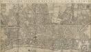
LARGE AND ACCURATE MAP OF THE CITY OF LONDON. Ichnographically describing all the Streets, Lanes, Alleys, Courts, Yards, Churches, Halls and Houses, &Amp;c
1 : 1200 Large map of London printed in 20 sheets featuring title along the top, city arms and dedication to the Lord Mayor, the Aldermen and Sheriffs of the city in cartouche at top left and arms of Sheldon, Lord Mayor at top right and with compass star and dividers at bottom centre. This is the first accurate and detailed map of London, with all the buildings represented in plan rather than as bird's eye views. Ogilby, John and Morgan, William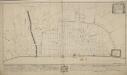
A "plan of the city of London after the great fire in the year of our Lord 1666; with the modell of the new city according to the design and proposal of Sir Christopher Wren, Knt., etc., for rebuilding thereof;"

Insurance Plan of London: sheet 7
This detailed 1889 plan of London is one of a series of six sheets in an atlas originally produced to aid insurance companies in assessing fire risks. The building footprints, their use (commercial, residential, educational, etc.), the number of floors and the height of the building, as well as construction materials (and thus risk of burning) and special fire hazards (chemicals, kilns, ovens) were documented in order to estimate premiums. Names of individual businesses, property lines, and addresses were also often recorded. Together these maps provide a rich historical shapshot of the commercial activity and urban landscape of towns and cities at the time. The British Library holds a comprehensive collection of fire insurance plans produced by the London-based firm Charles E. Goad Ltd. dating back to 1885. These plans were made for most important towns and cities of the British Isles at the scales of 1:480 (1 inch to 40 feet), as well as many foreign towns at 1:600 (1 inch to 50 feet). Chas E Goad Limited Chas E Goad Limited
Insurance Plan of London Vol. XI: Key Plan
1 : 4800 This "key plan" indicates coverage of the Goad 1890 series of fire insurance maps of London that were originally produced to aid insurance companies in assessing fire risks. The building footprints, their use (commercial, residential, educational, etc.), the number of floors and the height of the building, as well as construction materials (and thus risk of burning) and special fire hazards (chemicals, kilns, ovens) were documented in order to estimate premiums. Names of individual businesses, property lines, and addresses were also often recorded. Together these maps provide a rich historical shapshot of the commercial activity and urban landscape of towns and cities at the time. The British Library holds a comprehensive collection of fire insurance plans produced by the London-based firm Charles E. Goad Ltd. dating back to 1885. These plans were made for most important towns and cities of the British Isles at the scales of 1:480 (1 inch to 40 feet), as well as many foreign towns at 1:600 (1 inch to 50 feet). Chas E Goad Limited Chas E Goad Limited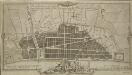
A Plan for Rebuilding the City of London after the Great Fire in 1666; Designed by that Great Architect Sr Chrisr. Wren; & approved by King and Parliament, but unhappily defeated by Faction.
1 : 31680 This is an 18th-Century copy of Sir Christopher Wren's plan for rebuilding London after the great fire destroyed seven-eighths of the city. Wren, at this point an Oxford astronomer with comparatively little architectural experience, was among the first to present a plan to Charles II after the catastrophe. The narrow streets which had helped the fire's progress are replaced on his plan by monumental avenues radiating from piazzas. The influence of the classical buildings and formal street plans which Wren had studied in Paris are a clear influence. He also proposes the construction of a Thameside quay from Bridewell to the Tower, replacing the ramshackle wooden wharfside buildings with warehouses. A vignette of 'Thamesis' (the putative river god) with London burning in the background has been added in the lower margin. Wren's plan was never used. Perhaps due to his eargerness to produce a plan quickly, he was inaccurate in making his ground plan and did not consider contours adequately. Neither king nor parliament were to ever take it seriously despite the title's assertion that it was an approved plan. Wren, Christopher
A MAP or GROVNDPLOT of the Citty of London within the Suburbes thereof
Engraved map of London with title in square tablet at top right and reference table with key to churches and other landmarks at bottom right. The map clearly shows the extent of the damage to the city caused by the great fire of 1666: the barren city wards in contrast with bird’s eye views of surviving buildings just outside the city. Also by Hollar is the inset map at bottom left entitled A General Map of the Whole Citty of London, Westminster and all the Suburbs. Smaller in scale but more extensive in coverage, the inset map shows at a glance the extent of the damage caused by the fire. This small map was probably the basis for the many variations on the theme of the London Verbrandt which were published in Amsterdam by Venckel and De Wit in the aftermath of the fire. The fire destroyed nearly the whole city 13,000 buildings circa and though the casualties were few 8 people only died directly because of the fire thousands were made homeless. Hollar, Wenceslaus
A MAP or GROVNDPLOT OF THE CITTY OF LONDON, WITH THE SVBVRBES THEREOF
1 : 9386 Engraved map of London with title along the top, reference table with key to the city's landmarks and churches at top right and bottom left respectively and with compass star and scale bar at bottom right. The map shows the extent of the damage to the city caused by the great fire of 1666; the barren city wards contrasting with birds eye views of surviving buildings just outside the city. This small map was probably the basis for the many variations on the theme of the "London Verbrandt" which were published in Amsterdam by Venckel and De Wit in the aftermath of the fire. The fire broke out at a bakers shop on Pudding Lane near London Bridge on the 2nd of September 1666. The fire destroyed nearly the whole city 13.000 buildings circa and though the casualties were few only eight people died because of the fire thousands were made homeless. Hollar, Wenceslaus
A New and Plaine Mapp of the CITTY of LONDON Shewing the Streets, Lanes, Allies, Courts, Churches Halls and other remarkable places as they are now rebuilt
The title of this map of the City of London appears along the top, with tables of references at top left and right, a compass rose depicted along the river course. St Paul’s Cathedral, the Tower of London, the Roman wall and ships sailing along the Thames are all shown pictorially. The map's publisher, John Overton, had acquired Peter Stent's stock in the mid-17th Century. This stock included many maps by leading Tudor cartographers. His son Henry succeeded him in 1703 and continued the family's publishing business. Overton, John
LONDINIUM
The author of this plan of Roman London, John Britton, was an antiquary and passionate advocate of the preservation of ancient monuments. The plan shows the Roman wall, gates, street plan and road network, with some prominent architectural and geographical features presented pictorially. Britton, John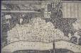
An exact Surveigh of the Streets, Lanes, and Churches contained within the ruines of the City of London, first described in six plats
N. Brooke