Maps of Islington

Insurance Plan of London Vol. XI: sheet 300~r_2
1 : 480 This detailed 1890 plan of London is one of a series of thirty-one sheets in an atlas originally produced to aid insurance companies in assessing fire risks. The building footprints, their use (commercial, residential, educational, etc.), the number of floors and the height of the building, as well as construction materials (and thus risk of burning) and special fire hazards (chemicals, kilns, ovens) were documented in order to estimate premiums. Names of individual businesses, property lines, and addresses were also often recorded. Together these maps provide a rich historical shapshot of the commercial activity and urban landscape of towns and cities at the time. The British Library holds a comprehensive collection of fire insurance plans produced by the London-based firm Charles E. Goad Ltd. dating back to 1885. These plans were made for most important towns and cities of the British Isles at the scales of 1:480 (1 inch to 40 feet), as well as many foreign towns at 1:600 (1 inch to 50 feet). Chas E Goad Limited Chas E Goad Limited
Insurance Plan of London Vol. XI: sheet 312-2
1 : 480 This detailed 1890 plan of London is one of a series of thirty-one sheets in an atlas originally produced to aid insurance companies in assessing fire risks. The building footprints, their use (commercial, residential, educational, etc.), the number of floors and the height of the building, as well as construction materials (and thus risk of burning) and special fire hazards (chemicals, kilns, ovens) were documented in order to estimate premiums. Names of individual businesses, property lines, and addresses were also often recorded. Together these maps provide a rich historical shapshot of the commercial activity and urban landscape of towns and cities at the time. The British Library holds a comprehensive collection of fire insurance plans produced by the London-based firm Charles E. Goad Ltd. dating back to 1885. These plans were made for most important towns and cities of the British Isles at the scales of 1:480 (1 inch to 40 feet), as well as many foreign towns at 1:600 (1 inch to 50 feet). Chas E Goad Limited Chas E Goad Limited
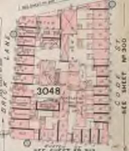
Insurance Plan of London Vol. XI: sheet 300-1
1 : 480 This detailed 1890 plan of London is one of a series of thirty-one sheets in an atlas originally produced to aid insurance companies in assessing fire risks. The building footprints, their use (commercial, residential, educational, etc.), the number of floors and the height of the building, as well as construction materials (and thus risk of burning) and special fire hazards (chemicals, kilns, ovens) were documented in order to estimate premiums. Names of individual businesses, property lines, and addresses were also often recorded. Together these maps provide a rich historical shapshot of the commercial activity and urban landscape of towns and cities at the time. The British Library holds a comprehensive collection of fire insurance plans produced by the London-based firm Charles E. Goad Ltd. dating back to 1885. These plans were made for most important towns and cities of the British Isles at the scales of 1:480 (1 inch to 40 feet), as well as many foreign towns at 1:600 (1 inch to 50 feet). Chas E Goad Limited Chas E Goad Limited
A New & Exact Plan of ye City of LONDON, detail showing Spitalfields
Detail showing Bethnal Green from Bowles' folding map of London of 1731. This is a later edition of the map first issued by Bowles in 1719 extended to include Stepney and the Isle of Dogs. Bowles based this part of the map on Gascoigne’s Survey of Stepney of 1703. Gascoigne, J.
A Map of the Parish of St. Dunstans Stepney, als. Stebunheath.
A. Churchill
PLAN OF THE CITY OF LONDON DIVIDED INTO WARDS
This plan was published in Allen's 'History of London' of 1828. Its title and a list of the city wards feature below the plan, with ward boundaries indicated by a dotted line. City wards were created in the Norman era with aldermen elected for life for the purpose of government. Ward 'beadles' were employed fulltime with responsibility for the "preservation of peace, supervision of trading, sanitation and local upkeep". Allen, Thomas
General Plan of the City of London
Haywood, William London
A new and exact plan of the city of London and suburbs thereof, 3
1 Blatt : 58 x 50 cm Henry Overton
LARGE AND ACCURATE MAP OF THE CITY OF LONDON. Ichnographically describing all the Streets, Lanes, Alleys, Courts, Yards, Churches, Halls and Houses, &Amp;c
1 : 1200 Large map of London printed in 20 sheets featuring title along the top, city arms and dedication to the Lord Mayor, the Aldermen and Sheriffs of the city in cartouche at top left and arms of Sheldon, Lord Mayor at top right and with compass star and dividers at bottom centre. This is the first accurate and detailed map of London, with all the buildings represented in plan rather than as bird's eye views. Ogilby, John and Morgan, William
A "plan of the city of London after the great fire in the year of our Lord 1666; with the modell of the new city according to the design and proposal of Sir Christopher Wren, Knt., etc., for rebuilding thereof;"

Insurance Plan of London: sheet 7
This detailed 1889 plan of London is one of a series of six sheets in an atlas originally produced to aid insurance companies in assessing fire risks. The building footprints, their use (commercial, residential, educational, etc.), the number of floors and the height of the building, as well as construction materials (and thus risk of burning) and special fire hazards (chemicals, kilns, ovens) were documented in order to estimate premiums. Names of individual businesses, property lines, and addresses were also often recorded. Together these maps provide a rich historical shapshot of the commercial activity and urban landscape of towns and cities at the time. The British Library holds a comprehensive collection of fire insurance plans produced by the London-based firm Charles E. Goad Ltd. dating back to 1885. These plans were made for most important towns and cities of the British Isles at the scales of 1:480 (1 inch to 40 feet), as well as many foreign towns at 1:600 (1 inch to 50 feet). Chas E Goad Limited Chas E Goad Limited
Insurance Plan of London Vol. XI: Key Plan
1 : 4800 This "key plan" indicates coverage of the Goad 1890 series of fire insurance maps of London that were originally produced to aid insurance companies in assessing fire risks. The building footprints, their use (commercial, residential, educational, etc.), the number of floors and the height of the building, as well as construction materials (and thus risk of burning) and special fire hazards (chemicals, kilns, ovens) were documented in order to estimate premiums. Names of individual businesses, property lines, and addresses were also often recorded. Together these maps provide a rich historical shapshot of the commercial activity and urban landscape of towns and cities at the time. The British Library holds a comprehensive collection of fire insurance plans produced by the London-based firm Charles E. Goad Ltd. dating back to 1885. These plans were made for most important towns and cities of the British Isles at the scales of 1:480 (1 inch to 40 feet), as well as many foreign towns at 1:600 (1 inch to 50 feet). Chas E Goad Limited Chas E Goad Limited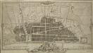
A Plan for Rebuilding the City of London after the Great Fire in 1666; Designed by that Great Architect Sr Chrisr. Wren; & approved by King and Parliament, but unhappily defeated by Faction.
1 : 31680 This is an 18th-Century copy of Sir Christopher Wren's plan for rebuilding London after the great fire destroyed seven-eighths of the city. Wren, at this point an Oxford astronomer with comparatively little architectural experience, was among the first to present a plan to Charles II after the catastrophe. The narrow streets which had helped the fire's progress are replaced on his plan by monumental avenues radiating from piazzas. The influence of the classical buildings and formal street plans which Wren had studied in Paris are a clear influence. He also proposes the construction of a Thameside quay from Bridewell to the Tower, replacing the ramshackle wooden wharfside buildings with warehouses. A vignette of 'Thamesis' (the putative river god) with London burning in the background has been added in the lower margin. Wren's plan was never used. Perhaps due to his eargerness to produce a plan quickly, he was inaccurate in making his ground plan and did not consider contours adequately. Neither king nor parliament were to ever take it seriously despite the title's assertion that it was an approved plan. Wren, Christopher
A MAP or GROVNDPLOT OF THE CITTY OF LONDON, WITH THE SVBVRBES THEREOF
1 : 9386 Engraved map of London with title along the top, reference table with key to the city's landmarks and churches at top right and bottom left respectively and with compass star and scale bar at bottom right. The map shows the extent of the damage to the city caused by the great fire of 1666; the barren city wards contrasting with birds eye views of surviving buildings just outside the city. This small map was probably the basis for the many variations on the theme of the "London Verbrandt" which were published in Amsterdam by Venckel and De Wit in the aftermath of the fire. The fire broke out at a bakers shop on Pudding Lane near London Bridge on the 2nd of September 1666. The fire destroyed nearly the whole city 13.000 buildings circa and though the casualties were few only eight people died because of the fire thousands were made homeless. Hollar, Wenceslaus
LONDINIUM
The author of this plan of Roman London, John Britton, was an antiquary and passionate advocate of the preservation of ancient monuments. The plan shows the Roman wall, gates, street plan and road network, with some prominent architectural and geographical features presented pictorially. Britton, John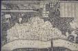
An exact Surveigh of the Streets, Lanes, and Churches contained within the ruines of the City of London, first described in six plats
N. Brooke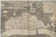
AN EXACT SURVEIGH OF THE STREETS LANES AND CHVRCHES CONTAINED WITHIN THE RVINES OF THE CITY OF LONDON FIRST DESCRIBED IN SIX PLATS
1 : 3620 This map was reduced by John Leake from a large-scale survey on six sheets produced in December 1666 to assess the damage caused by the great fire. No copy of this large scale survey has ever been found. This is the second edition of this map, Updated and issued in 1669 with a dedication to Sir William Turner, The Lord Mayor of London for that year. The map's title appears along the top of the manuscript, With the City arms and dedication at top centre. The key to buildings destroyed in the fire appears in a table at top right, With a compass star at bottom right, Scale bar and imprint at bottom left, And an illustration of the city on fire inset at top left. The location of livery halls destroyed in the fire is indicated by their respective coats of arms. Letters identify individual City wards, With ward boundaries indicated by a pecked line. Buildings outside the city walls, Undamaged by the fire, Are represented three dimensionally. Leake, John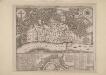
An Exact Map representing the conditions of the late famous and flourishing City of London
1 : 6336 Engraved map of London and suburbs (including Lincoln Inn Fields, Finsbury Fields, Smith Fields and Bankside in Southwark) in which barren city wards contrast with birds eye views of surviving buildings outside the city, showing at a glancethe extent of the damage to the city caused by the great fire of 1666. The map features title along the top, with arms of the city and compass rose depicted at top left and right respectively. Also by Pricke is the inset map in the panel at the foot of the plate. Entitled "A map of the Whole City of London and Westminster with the Suburbs, Whearein May Be Judged What Proportion is Burnt and What Remains Standing", this smaller scale map (two inches to the mile) is flanked by reference tables with key to churches and halls of the London Livery companies. Pricke, Robert
An Actual Survey of the Parish of St. Leonard in Shoreditch, Middlesex, taken in the Year 1745 by Peter Chassereau. 4
1 : 3000 Plan of the parish of St. Leonard in Shoreditch with title in cartouche at top left, compass at top right, scale bar at bottom centre and key to streets, courts, alleys, squares etc. in table at lower right. Each field in the parish is shown with the name of the landlord or tenant and the dimensions. Chassereau
A guide for Cuntrey men In the famous Cittey of LONDON by the helpe of wich plot they shall be able to know how farr it is to any Street...
This 1593 map is the direct forbear of the modern London A-Z. This copy comes from the 1653 edition of John Norden's 'Speculum Britainiae' (literally: 'Mirror of Britain'), re-issued after Norden's death and sold by Peter Stent of Newgate. Around the edges of the map appear the coats of arms of the twelve most influential and wealthy city guilds: the 'Great Liveries'. Guild members became known as liverymen because they wore a distinctive livery or uniform. At top right is the Merchant Tailors company, which made tents and padded tunics during the middle ages. This is reflected by the tent motif on the coat of arms. Norden, John
the Cittie of London 31
This map has been attributed to Augustus Ryther, an engraver who prospered between 1572 and 1592, contributing to Saxton's Atlas of 1579. This plan was produced to satisfy a European market, and contains certain inaccuracies which a native Londoner would not have tolerated. The streets appear very much wider than they were in actuality. Houses are depicted as having large gardens, when these had, in fact, begun to disappear from London two centuries before. The map details the gap at the north end of London Bridge, caused by a fire in 1632. Ryther, Augustus
the Cittie of London 32
This map has been attributed to Augustus Ryther, an engraver who prospered between 1572 and 1592, contributing to Saxton's Atlas of 1579. This plan was produced to satisfy a European market, and contains certain inaccuracies which a native Londoner would not have tolerated. The streets appear very much wider than they were in actuality. Houses are depicted as having large gardens, when these had, in fact, begun to disappear from London two centuries before. Due to the scarcity of maps of London this rather misleading map was printed several times. This is the second edition. The map-seller's imprint has been removed and a large compass rose has been inserted. The Globe playhouse has been omitted on this edition, because of the theatre's destruction in 1644. Hoge Lane, Bedlam and Finsbury Fields have also been added. The map is shows the water conduit near Fleet Bridge, an important link in the water supply line from St Pancras. Ryther, Augustus
Vrbium Londini et West-Monasterii nec non suburbii Southwark accurata ichnographia, 2
1 Blatt : 52 x 62 cm Homännische Erben
LONDINIUM Augusta
1 : 11019 The title of this engraved map of Roman London appears along the top, with compass rose at top right.The arms of the Count of Pembroke, to whom the map is dedicated, are depicted at bottom right. Published in 'Itinerarium Curiosum' by William Stukeley, an antiquarian with a scholarly interest in sacred history, the plan shows the Roman street plan and road network, with illustrated views of the city wall and other prominent architectural and geographical features. Stukeley, Dr. William
The Jew in London. A study of racial character and present-day conditions.
Arkill, G.E. T. Fisher Unwin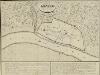
The City of LONDON in the Time of the Saxons (about the Year 1000) compiled from the most authentic DOCUMENTS
Map of London in the reign of the Saxon King Ethelred II, with the history of Roman and Saxon London written in a panel below the plan. The map shows the Roman wall still standing, but the street plan suggests that, compared to the Roman period, the built-up area occupied a much smaller part of the walled city and that the population was in rapid decline. Wallis
Englands glory, or, the glory of England being a new mapp of the city of London : shewing the remarkable streets, lanes, alleyes, churches, halls courts, and other places as they are now rebuilt, the which will therefore be a guide to strangers, and such as are not well acquainted herein to direct them from place to place : diverse faults y[t] are in y[e] former are in this amended, allsoe the severall figures y[t] stand up and downe in the mapp are explained in y[e] 2 tables at y[e] upper corners hereof.
Walton, Robert, 1618-1688 Robert Walton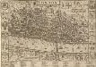
LONDON 21
This map was published in Norden's 1593 'Speculum Britanniae. The first parte. An historical and chronographical description of Middlesex'. The map is flanked by the arms of the twelve great livery companies and features title at the top with royal and city arms. The scale bar is at top right and a key to inns, churches, halls and other prominent places feature in a panel below the plan. The map was intended for countrymen visiting the city and was reissued in 1623 and 1653 with enlarged tables of reference. Norden, John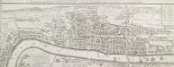
LONDON and WESTMINSTER in the Reign of QUEEN ELIZABETH Anno Dom. 1563
This is a retrospective map of Elizabethan London, giving us an idea of how people in the late 18th Century viewed the Elizabethan capital. The present-day Covent Garden is an area of fields named "Convent Garden”, indicating that the area belonged to the Abbey of St Peter's at Westminster before the dissolution of monasteries in the reign of Henry VIII. The location of Tower Bridge is marked, although the actual bridge was not planned until 1879. This indicates that Londoners were thinking about bridging the river at this point one hundred years before the decisive plan to do so. Wallis, J.