Maps of Islington

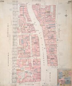
Insurance Plan of London Vol. XI: sheet 296
1 : 480 This detailed 1890 plan of London is one of a series of thirty-one sheets in an atlas originally produced to aid insurance companies in assessing fire risks. The building footprints, their use (commercial, residential, educational, etc.), the number of floors and the height of the building, as well as construction materials (and thus risk of burning) and special fire hazards (chemicals, kilns, ovens) were documented in order to estimate premiums. Names of individual businesses, property lines, and addresses were also often recorded. Together these maps provide a rich historical shapshot of the commercial activity and urban landscape of towns and cities at the time. The British Library holds a comprehensive collection of fire insurance plans produced by the London-based firm Charles E. Goad Ltd. dating back to 1885. These plans were made for most important towns and cities of the British Isles at the scales of 1:480 (1 inch to 40 feet), as well as many foreign towns at 1:600 (1 inch to 50 feet). Chas E Goad Limited Chas E Goad Limited
Insurance Plan of London Vol. XI: sheet 294-2
1 : 480 This detailed 1890 plan of London is one of a series of thirty-one sheets in an atlas originally produced to aid insurance companies in assessing fire risks. The building footprints, their use (commercial, residential, educational, etc.), the number of floors and the height of the building, as well as construction materials (and thus risk of burning) and special fire hazards (chemicals, kilns, ovens) were documented in order to estimate premiums. Names of individual businesses, property lines, and addresses were also often recorded. Together these maps provide a rich historical shapshot of the commercial activity and urban landscape of towns and cities at the time. The British Library holds a comprehensive collection of fire insurance plans produced by the London-based firm Charles E. Goad Ltd. dating back to 1885. These plans were made for most important towns and cities of the British Isles at the scales of 1:480 (1 inch to 40 feet), as well as many foreign towns at 1:600 (1 inch to 50 feet). Chas E Goad Limited Chas E Goad Limited
Plan of an Estate in ST. LEONARDS, SHOREDITCH
Plan of an estate in Shoreditch with title and imprint at bottom centre. The estete is divided into lots for the sale at auction by Crawter Auctioneers. Cartwright, R.
Insurance Plan of London Vol. XI: sheet 298
1 : 480 This detailed 1890 plan of London is one of a series of thirty-one sheets in an atlas originally produced to aid insurance companies in assessing fire risks. The building footprints, their use (commercial, residential, educational, etc.), the number of floors and the height of the building, as well as construction materials (and thus risk of burning) and special fire hazards (chemicals, kilns, ovens) were documented in order to estimate premiums. Names of individual businesses, property lines, and addresses were also often recorded. Together these maps provide a rich historical shapshot of the commercial activity and urban landscape of towns and cities at the time. The British Library holds a comprehensive collection of fire insurance plans produced by the London-based firm Charles E. Goad Ltd. dating back to 1885. These plans were made for most important towns and cities of the British Isles at the scales of 1:480 (1 inch to 40 feet), as well as many foreign towns at 1:600 (1 inch to 50 feet). Chas E Goad Limited Chas E Goad Limited
Insurance Plan of London Vol. XI: sheet 294-1
1 : 480 This detailed 1890 plan of London is one of a series of thirty-one sheets in an atlas originally produced to aid insurance companies in assessing fire risks. The building footprints, their use (commercial, residential, educational, etc.), the number of floors and the height of the building, as well as construction materials (and thus risk of burning) and special fire hazards (chemicals, kilns, ovens) were documented in order to estimate premiums. Names of individual businesses, property lines, and addresses were also often recorded. Together these maps provide a rich historical shapshot of the commercial activity and urban landscape of towns and cities at the time. The British Library holds a comprehensive collection of fire insurance plans produced by the London-based firm Charles E. Goad Ltd. dating back to 1885. These plans were made for most important towns and cities of the British Isles at the scales of 1:480 (1 inch to 40 feet), as well as many foreign towns at 1:600 (1 inch to 50 feet). Chas E Goad Limited Chas E Goad Limited
Insurance Plan of London Vol. VI: sheet 148
1 : 480 This detailed 1887 plan of London is one of a series of twenty-seven sheets in an atlas originally produced to aid insurance companies in assessing fire risks. The building footprints, their use (commercial, residential, educational, etc.), the number of floors and the height of the building, as well as construction materials (and thus risk of burning) and special fire hazards (chemicals, kilns, ovens) were documented in order to estimate premiums. Names of individual businesses, property lines, and addresses were also often recorded. Together these maps provide a rich historical shapshot of the commercial activity and urban landscape of towns and cities at the time. The British Library holds a comprehensive collection of fire insurance plans produced by the London-based firm Charles E. Goad Ltd. dating back to 1885. These plans were made for most important towns and cities of the British Isles at the scales of 1:480 (1 inch to 40 feet), as well as many foreign towns at 1:600 (1 inch to 50 feet). Chas E Goad Limited Chas E Goad Limited
Insurance Plan of London Vol. XI: sheet 293
1 : 480 This detailed 1890 plan of London is one of a series of thirty-one sheets in an atlas originally produced to aid insurance companies in assessing fire risks. The building footprints, their use (commercial, residential, educational, etc.), the number of floors and the height of the building, as well as construction materials (and thus risk of burning) and special fire hazards (chemicals, kilns, ovens) were documented in order to estimate premiums. Names of individual businesses, property lines, and addresses were also often recorded. Together these maps provide a rich historical shapshot of the commercial activity and urban landscape of towns and cities at the time. The British Library holds a comprehensive collection of fire insurance plans produced by the London-based firm Charles E. Goad Ltd. dating back to 1885. These plans were made for most important towns and cities of the British Isles at the scales of 1:480 (1 inch to 40 feet), as well as many foreign towns at 1:600 (1 inch to 50 feet). Chas E Goad Limited Chas E Goad Limited
An Actual Survey of the Parish of St. Leonard in Shoreditch, Middlesex, taken in the Year 1745 by Peter Chassereau. 5
Survey of the roads from Old Street Church to Shoreditch Church with both churches shown pictorially, scale bar at lower right, orientation points marked on margins and key to distances between junctions in table at middle left.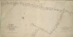
Plan of the Highways held under the Trustees of the OLD STREET TURNPIKE ROADS in the County of Middlesex
Survey of the streets in the Old Street Turnpike Roads Trust, London, from Goswell Street to Hackney Road with title and scale bar at lower left, compass in the centre and key to distances between junctions in table at bottom right. Wickings, W.
A Map of the Parish of St. Dunstans Stepney, als. Stebunheath.
A. Churchill
SCHOREDITCH, NORTON FALGATE and CRIPPLEGATE WITHOUT. Taken From y.e last Survey With Corrections 3A
1 : 4800 Plan of Shoreditch in the City of London, published in Strype's first annotated edition of Stow's 'Survey of England'. The plan features title in cartouche at the top of the plate, scale bar and compass at bottom left and key to streets, yards, squares, churches and public buildings in tables at top left and lower right. A dotted line marks the boundary between the parish of St. Leonard Shoreditch and St. Giles Cripple Gate. Hoxton Square, where the development of Shoreditch began in the 1680's is indicated at top right. Blome, Richard
London (1915- Numbered sheets) V.7 (includes: Bethnal Green; Shoreditch; Stepney) - 25 Inch Map
1 : 2500 Topographic maps Ordnance Survey Ordnance Survey
London (Edition of 1894-96) LI (includes: Bethnal Green; Shoreditch; Stepney) - 25 Inch Map
1 : 2500 Topographic maps Ordnance Survey Ordnance Survey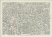
London (First Editions c1850s) XXVII (includes: Bethnal Green; Shoreditch; Stepney) - 25 Inch Map
1 : 2500 Topographic maps Ordnance Survey Ordnance Survey
Insurance Plan of London: sheet 7
This detailed 1889 plan of London is one of a series of six sheets in an atlas originally produced to aid insurance companies in assessing fire risks. The building footprints, their use (commercial, residential, educational, etc.), the number of floors and the height of the building, as well as construction materials (and thus risk of burning) and special fire hazards (chemicals, kilns, ovens) were documented in order to estimate premiums. Names of individual businesses, property lines, and addresses were also often recorded. Together these maps provide a rich historical shapshot of the commercial activity and urban landscape of towns and cities at the time. The British Library holds a comprehensive collection of fire insurance plans produced by the London-based firm Charles E. Goad Ltd. dating back to 1885. These plans were made for most important towns and cities of the British Isles at the scales of 1:480 (1 inch to 40 feet), as well as many foreign towns at 1:600 (1 inch to 50 feet). Chas E Goad Limited Chas E Goad Limited
Insurance Plan of London Vol. XI: Key Plan
1 : 4800 This "key plan" indicates coverage of the Goad 1890 series of fire insurance maps of London that were originally produced to aid insurance companies in assessing fire risks. The building footprints, their use (commercial, residential, educational, etc.), the number of floors and the height of the building, as well as construction materials (and thus risk of burning) and special fire hazards (chemicals, kilns, ovens) were documented in order to estimate premiums. Names of individual businesses, property lines, and addresses were also often recorded. Together these maps provide a rich historical shapshot of the commercial activity and urban landscape of towns and cities at the time. The British Library holds a comprehensive collection of fire insurance plans produced by the London-based firm Charles E. Goad Ltd. dating back to 1885. These plans were made for most important towns and cities of the British Isles at the scales of 1:480 (1 inch to 40 feet), as well as many foreign towns at 1:600 (1 inch to 50 feet). Chas E Goad Limited Chas E Goad Limited
A New and Plaine Mapp of the CITTY of LONDON Shewing the Streets, Lanes, Allies, Courts, Churches Halls and other remarkable places as they are now rebuilt
The title of this map of the City of London appears along the top, with tables of references at top left and right, a compass rose depicted along the river course. St Paul’s Cathedral, the Tower of London, the Roman wall and ships sailing along the Thames are all shown pictorially. The map's publisher, John Overton, had acquired Peter Stent's stock in the mid-17th Century. This stock included many maps by leading Tudor cartographers. His son Henry succeeded him in 1703 and continued the family's publishing business. Overton, John
An Actual Survey of the Parish of St. Leonard in Shoreditch, Middlesex, taken in the Year 1745 by Peter Chassereau. 4
1 : 3000 Plan of the parish of St. Leonard in Shoreditch with title in cartouche at top left, compass at top right, scale bar at bottom centre and key to streets, courts, alleys, squares etc. in table at lower right. Each field in the parish is shown with the name of the landlord or tenant and the dimensions. Chassereau
The Jew in London. A study of racial character and present-day conditions.
Arkill, G.E. T. Fisher Unwin
A new and exact plan of the city of London and suburbs thereof, 2
1 Blatt : 60 x 51 cm Henry Overton
Englands glory, or, the glory of England being a new mapp of the city of London : shewing the remarkable streets, lanes, alleyes, churches, halls courts, and other places as they are now rebuilt, the which will therefore be a guide to strangers, and such as are not well acquainted herein to direct them from place to place : diverse faults y[t] are in y[e] former are in this amended, allsoe the severall figures y[t] stand up and downe in the mapp are explained in y[e] 2 tables at y[e] upper corners hereof.
Walton, Robert, 1618-1688 Robert Walton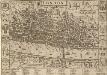
LONDON 21
This map was published in Norden's 1593 'Speculum Britanniae. The first parte. An historical and chronographical description of Middlesex'. The map is flanked by the arms of the twelve great livery companies and features title at the top with royal and city arms. The scale bar is at top right and a key to inns, churches, halls and other prominent places feature in a panel below the plan. The map was intended for countrymen visiting the city and was reissued in 1623 and 1653 with enlarged tables of reference. Norden, John
LONDON and WESTMINSTER in the Reign of QUEEN ELIZABETH, Anno Dom. 1563 25
This retrospective map of Elizabethan London was produced in the 1820s. It provides us with an idea of how people in the19th century viewed the Elizabethan city. The location of Tower Bridge is indicated on this map, even though plans for the actual bridge were not made until 1879. Neele, George
London VII.NE - OS Six-Inch Map
1 : 10560 Topographic maps Ordnance Survey Ordnance Survey
Newcourt's 'Map of London', detail showing the East End
Richard Newcourt’s map, made in 1658, represents the first complete survey of London since the 1550s. It shows the City and its surrounding countryside in the closing years of the Commonwealth. Though most buildings are depicted in a conventionalised way, the map gives some idea of the actual appearance of more important places, such as churches and livery halls. The inclusion of their coats of arms in the map's decoration suggests the Livery Companies may have commissioned Newcourt's work. The map provides a fairly accurate picture of the development of the City's eastern suburbs, already spreading along the roads that reached out across the countryside towards the surrounding villages. As well as being the docklands of London, this was the area where the first native English school of chartmaking, the so-called 'Thames School', was getting underway at the very time this map was made. Newcourt, Richard
LONDON FERACISSIMI ANGLIAE REGNI METROPOLIS
The title of this map of London appears at the top of the plate, flanked by Tudor and city arms. A note on the history of London features at bottom left and on the Steelyard at bottom right. Illustrated figures of merchants appear at bottom centre. Published in 'Civitates Orbis Terrarum', the map is similar in detail to the 'Copperplate Map', the earliest printed map of London of which no complete copy survives. Merchant ships, cranes, mills, bull and bear baiting pits, the large tennis courts at Westminster and the stags in St. James’s are examples of London business and leisure activities. Walled gardens, elegant churches and livery halls testify to the high quality of life enjoyed by its citizens. Braun, Georg & Hogenberg, Frans
Handy Reference Atlas of London
Edinburgh : John Bartholomew & Co.,
A Plan of London, Westminst.r and Southwark
This is derivative of Hatton's edition of Braun & Hogenberg's map-view of London. Unusually for a map of its time, most of the buildings are represented in plan instead of pictorially. The Latin text at the foot of the plate in the original are replaced by notes, in English, on the geographic and demographic growth of the city. Braun, Georg & Hogenberg, Frans
A NEW PLAN of the CITY of LONDON and BOROUGH OF SOUTHWARK, Exhibiting all the New Streets & Roads &c. Not extant in any other Plan.
1 : 14080 Thomas Jeffreys was an exceptional cartographer and publisher whose productions included maps of North America, considered to be among the finest of the time.This map of the City of London and the Borough of Southwark shows important buildings such as the Tower of London and St Paul's in plan form, differing from many earlier examples, which show them in elevation. It is dedicated to the Right Honourable Lord Mayor Aldermen and to the Commissioners of the Sewers, Lamps and Pavements. Jeffreys, Thomas