Maps of Lambeth

Insurance Plan of London Vol. X: sheet 252-1
1 : 480 This detailed 1889 plan of London is one of a series of thirty-five sheets in an atlas originally produced to aid insurance companies in assessing fire risks. The building footprints, their use (commercial, residential, educational, etc.), the number of floors and the height of the building, as well as construction materials (and thus risk of burning) and special fire hazards (chemicals, kilns, ovens) were documented in order to estimate premiums. Names of individual businesses, property lines, and addresses were also often recorded. Together these maps provide a rich historical shapshot of the commercial activity and urban landscape of towns and cities at the time. The British Library holds a comprehensive collection of fire insurance plans produced by the London-based firm Charles E. Goad Ltd. dating back to 1885. These plans were made for most important towns and cities of the British Isles at the scales of 1:480 (1 inch to 40 feet), as well as many foreign towns at 1:600 (1 inch to 50 feet). Chas E Goad Limited Chas E Goad Limited
Insurance Plan of City of London Vol. IV: sheet 94-2
1 : 480 This detailed 1887 plan of London is one of a series of twenty-three sheets in an atlas originally produced to aid insurance companies in assessing fire risks. The building footprints, their use (commercial, residential, educational, etc.), the number of floors and the height of the building, as well as construction materials (and thus risk of burning) and special fire hazards (chemicals, kilns, ovens) were documented in order to estimate premiums. Names of individual businesses, property lines, and addresses were also often recorded. Together these maps provide a rich historical shapshot of the commercial activity and urban landscape of towns and cities at the time. The British Library holds a comprehensive collection of fire insurance plans produced by the London-based firm Charles E. Goad Ltd. dating back to 1885. These plans were made for most important towns and cities of the British Isles at the scales of 1:480 (1 inch to 40 feet), as well as many foreign towns at 1:600 (1 inch to 50 feet). Chas E Goad Limited Chas E Goad Limited
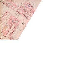
London South East Vol. J: sheet 8
1 : 480 This detailed 1897 plan of London is one of a series of twenty-seven sheets in an atlas originally produced to aid insurance companies in assessing fire risks. The building footprints, their use (commercial, residential, educational, etc.), the number of floors and the height of the building, as well as construction materials (and thus risk of burning) and special fire hazards (chemicals, kilns, ovens) were documented in order to estimate premiums. Names of individual businesses, property lines, and addresses were also often recorded. Together these maps provide a rich historical shapshot of the commercial activity and urban landscape of towns and cities at the time. The British Library holds a comprehensive collection of fire insurance plans produced by the London-based firm Charles E. Goad Ltd. dating back to 1885. These plans were made for most important towns and cities of the British Isles at the scales of 1:480 (1 inch to 40 feet), as well as many foreign towns at 1:600 (1 inch to 50 feet). Chas E Goad Limited Chas E Goad Limited
London South East Vol. J: sheet 7
1 : 480 This detailed 1897 plan of London is one of a series of twenty-seven sheets in an atlas originally produced to aid insurance companies in assessing fire risks. The building footprints, their use (commercial, residential, educational, etc.), the number of floors and the height of the building, as well as construction materials (and thus risk of burning) and special fire hazards (chemicals, kilns, ovens) were documented in order to estimate premiums. Names of individual businesses, property lines, and addresses were also often recorded. Together these maps provide a rich historical shapshot of the commercial activity and urban landscape of towns and cities at the time. The British Library holds a comprehensive collection of fire insurance plans produced by the London-based firm Charles E. Goad Ltd. dating back to 1885. These plans were made for most important towns and cities of the British Isles at the scales of 1:480 (1 inch to 40 feet), as well as many foreign towns at 1:600 (1 inch to 50 feet). Chas E Goad Limited Chas E Goad Limited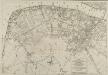
PLAN OF THE STREETS, ROADS &c. BETWEEN LAMBETH AND SOUTHWARK
1 : 5280 This is a plan of Saint George's Fields, between Lambeth and Southwark, with the title and scale bar in a table at bottom right and compass rose at bottom centre. The plan shows the proposals for Blackfriars Road and the southern approaches to Blackfriars Bridge as finally laid out during the period 1770-1800. Kitchin, Thomas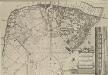
A Plan of the Streets, Roads &c. Between Black Fryers Bridge &c.
The title of this plan of Saint George's Fields, Southwark, appears in a table at bottom right, with a compass star at bottom centre, scale bar at top right, and an inset view of Blackfriars Bridge along the right margin. The plan shows the proposals for Blackfriars Road and the southern approaches to Blackfriars Bridge as they were finally laid during the last quarter of the 18th Century. Kitchin, Thomas
A Map of the Surrey Side the Thames from Westminster Bridge to the Borough. With a Plan for laying out the Roads, to BLACK FRYARS BRIDGE
The title of this map of St. George's Fields, Southwark, appears below the plan with key at bottom right. Alternative plans for laying out Blackfriars Road are indicated by double-dotted and pricked lines. The mile-long road was finally finished in the last quarter of the 18th Century.
London South East Vol J: sheet 2
This detailed 1897 plan of London is one of a series of twenty-seven sheets in an atlas originally produced to aid insurance companies in assessing fire risks. The building footprints, their use (commercial, residential, educational, etc.), the number of floors and the height of the building, as well as construction materials (and thus risk of burning) and special fire hazards (chemicals, kilns, ovens) were documented in order to estimate premiums. Names of individual businesses, property lines, and addresses were also often recorded. Together these maps provide a rich historical shapshot of the commercial activity and urban landscape of towns and cities at the time. The British Library holds a comprehensive collection of fire insurance plans produced by the London-based firm Charles E. Goad Ltd. dating back to 1885. These plans were made for most important towns and cities of the British Isles at the scales of 1:480 (1 inch to 40 feet), as well as many foreign towns at 1:600 (1 inch to 50 feet). Chas E Goad Limited Chas E Goad Limited
Vrbium Londini et West-Monasterii nec non suburbii Southwark accurata ichnographia, 2
1 Blatt : 52 x 62 cm Homännische Erben
A new and exact plan of the city of London and suburbs thereof, 2
1 Blatt : 60 x 51 cm Henry Overton
Standford's Library Map of London and its suburbs. Scale, 6 inches to 1 Eng. statute mile, or ... 1 : 10,560.
Stanford, Edward E. Stanford
FORD'S ILLUSTRATED MEMORIAL OF THE GRAND INDUSTRIAL EXHIBITION OF ALL NATIONS, HYDE PARK, LONDON 1851
This pictorial map commemorates the Great Exhibition of 1851, conceived by Henry Cole and presided over by Prince Albert. Theexhibition was held in the Crystal Palace. Designed by Joseph Paxton, it showcased exhibits from all over the world, including the largest pearl ever found, a knife with 300 blades, and the Koh-i-Noor diamond. The exhibition was opened by Queen Victoria in May 1851. She remained a frequent visitor, as did the Duke of Wellington. Only main roads in the capital are shown on this map and London locations are marked by small medallions containing scenes. Borders of roundels contain people from "all nations". Queen Victoria and Albert flank a view of the Crystal Palace, which was removed from Hyde Park in 1852andrebuilt at Sydenham. Simpson Ford, William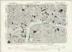
Surrey III.NW - OS Six-Inch Map
1 : 10560 Topographic maps Ordnance Survey Ordnance Survey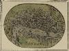
LONDON 20
A miniature map of London and Westminster with title at the foot of the plate and areas outside the built-up area coloured green.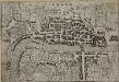
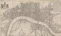
LONDRA
This small Italian etching is one of the earliest surviving maps of the city of London. It appeared in a book by Francesco Velagio entitled 'Raccolta di le piu` illustri et famose citta di tutto il mondo'. Published in Venice around 1595, the book depicts the main Italian and European cities. The map was copied for a fresco in a church in the Italian city of Mantua. Velagio, Francesco
LONDON FERACISSIMI ANGLIAE REGNI METROPOLIS
The title of this map of London appears at the top of the plate, flanked by Tudor and city arms. A note on the history of London features at bottom left and on the Steelyard at bottom right. Illustrated figures of merchants appear at bottom centre. Published in 'Civitates Orbis Terrarum', the map is similar in detail to the 'Copperplate Map', the earliest printed map of London of which no complete copy survives. Merchant ships, cranes, mills, bull and bear baiting pits, the large tennis courts at Westminster and the stags in St. James’s are examples of London business and leisure activities. Walled gardens, elegant churches and livery halls testify to the high quality of life enjoyed by its citizens. Braun, Georg & Hogenberg, Frans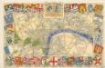
The Royal Wedding picture map of the road

A Plan of London, Westminst.r and Southwark
This is derivative of Hatton's edition of Braun & Hogenberg's map-view of London. Unusually for a map of its time, most of the buildings are represented in plan instead of pictorially. The Latin text at the foot of the plate in the original are replaced by notes, in English, on the geographic and demographic growth of the city. Braun, Georg & Hogenberg, Frans
A NEW PLAN of the CITY of LONDON and BOROUGH OF SOUTHWARK, Exhibiting all the New Streets & Roads &c. Not extant in any other Plan.
1 : 14080 Thomas Jeffreys was an exceptional cartographer and publisher whose productions included maps of North America, considered to be among the finest of the time.This map of the City of London and the Borough of Southwark shows important buildings such as the Tower of London and St Paul's in plan form, differing from many earlier examples, which show them in elevation. It is dedicated to the Right Honourable Lord Mayor Aldermen and to the Commissioners of the Sewers, Lamps and Pavements. Jeffreys, Thomas
LONDINUM FERACISSIMI ANGLIAE REGNI METROPOLIS
This derivative of Braun & Hogenberg's 1572 map of London was published in Belle Forest's 'La Cosmographie universelle de tout le monde'. The map's title features at the top of the plate, flanked by Tudor and city arms. Descriptive notes in French appear at bottom left and bottom right, with figures of merchants at bottom centre. The map is similar in detail to the 'Copperplate Map', the earliest printed map of London of which no complete copy survives. Merchant ships, cranes, mills, bull- and bear-baiting pits, the large tennis courts at Westminster and the stags in St. James’s are examples of London business and leisure activities. Walled gardens, elegant churches and livery halls testify to the high quality of life enjoyed by its citizens. Braun, Georg & Hogenberg, Frans
Plan of London, West.r and Southwark, w.th y.e Riv.r Thames, as they were survey.d and publisht by Authority toward y.e latter end of y.e reign of Queen Elizaabeth, or about y.e year of our Lord 1600.
This is the fourth edition of Braun &Hogenberg's map view of London. The title in cartouche at the foot of the plate replaces the figures of merchants from the earlier editions. Tudor arms feature at top right, with the city arms at top left and descriptive notes at bottom right and bottom left. Published in Hatton's 'A New View of London; or, an Ample Account of that City', the map is similar in detail to the 'Copperplate Map', the earliest printed map of London of which no complete copy survives. Merchant ships, cranes, mills, bull- and bear-baiting pits, the large tennis courts at Westminster and the stags in St. James’s are examples of London's business and leisure activities. Walled gardens, elegant churches and livery halls testify to the high quality of life enjoyed by its citizens. Braun, Georg & Hogenberg, Frans
AUTHENTIC REMAINS AND PROBABLE SITE OF ROMAN LONDON FROM THE BEST AUTHORITIES
This engraved map of Roman London was based on archaeological discoveries of the first half of the 19th Century. The map's title and scale bar feature at bottom right, with keys to sites of archaeological discoveries (coins, urns and vases in the City of London and in Southwark) in reference tables at top right and bottom left.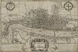
LONDINUM Vulgo LONDON
This later edition of Braun & Hogenberg's map of London and Westminster was published in Janssen's 'Illustrorem Principumque Urbium Septentrionalium Europae'. The map's title appears in a cartouche at the foot of the plate, replacing the figures of merchants of the first edition. Tudor arms feature top right, with city arms at top left and descriptive notes to the bottom right and bottom left. The map is similar in detail to the 'Copperplate Map', the earliest printed map of London of which no complete copy survives. Merchant ships, cranes, mills, bull and bear baiting pits, the large tennis courts at Westminster and the stags in St. James’s are examples of London's business and leisure activities. Walled gardens, elegant churches and livery halls testify to the high quality of life enjoyed by its citizens. Braun, Georg & Hogenberg, Frans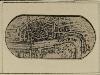
LONDON 19
The title of this miniature map of London features along the river. The map's orientation is reversed horizontally so that the west is represented on the right of the map.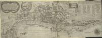
The Newest and Exactest MAPP of the most Famous Citties LONDON and WESTMINSTER, with their Suburbs; and the manner of their Streets:
The arms of the Commonwealth and of the City appear on the upper-left cornermap, facing the personifications of Justice and Prudence on the upper right. A number key is provided so users can find "the nearest way from one place to another." 'Pecadilly Hall' appears in place of modern Piccadilly. This was a derisive name for the country house built around1612 by Robert Baker, a tailor with a shop on the Strand. Baker made his fortune by selling "picadils" (a stiff collar popular at Court). By the 18th Century, Piccadilly was the name of the whole street. Porter, T.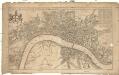
A new mapp of the city of London
1 : 7900 Londýn (Anglie) Overton, Henry John Overton
London, Westminster and Southwark
1 : 10138 This untitled map of Stuart London features royal arms at top left, city arms at top right, with a scale bar and dividers shown beneath a female figure with a globe at lower left. A key to Southwark's churches is provided at lower right. This map is derivative of Wenceslaus Hollar posthumously published plan of 1685 and features vignettes of prominent buildings along the top, together with portraits of King William and Queen Mary. At the foot of the plate, views of the seven city gates and the Tower of London accompany equestrian statues of Charles I and Charles II.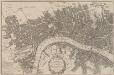
A POCKET MAP of the Cities of LONDON, WESTMINSTER & SOUTHWARK With the Addition of the Buildings to the Present Year
The title of this pocket map of London, Westminster and Southwark appears in cartouche at bottom centre alongside the city arms. A compass star is depicted in the river with a publisher’s imprint (in scroll) at bottom left. An engraver by trade, Thomas Bowles acquired the stock of cartographers Morden & Lea at the beginning of the 18th Century, starting a successful publishing house, the output of which was almost entirely derivative. Bowles' brother, John, was also a print seller and publisher. Their businesses were separate, but the two often worked together. Bowles, Thomas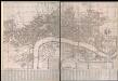
A New and Exact Plan of Ye City of London and Westminster, the Borough of Southwark, 1735
This map of London is probably based on an earlier map by William Morgan dating 1681-82. It features title in cartouche near bottom centre, rates of coaches and ferries to the right of the title and explanatory note to the left. The map is divided in squares with margins lettered for reference and key in columns at the foot of the plate. Westminster Bridge and other prominent buildings represented pictorially. Jeffreys, Thomas