Maps of Kingston upon Hull

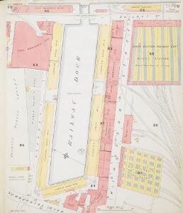
Insurance Plan of Hull (Yorkshire): sheet 10
1 : 480 This detailed 1886 plan of Hull is one of a series of twelve sheets in an atlas originally produced to aid insurance companies in assessing fire risks. The building footprints, their use (commercial, residential, educational, etc.), the number of floors and the height of the building, as well as construction materials (and thus risk of burning) and special fire hazards (chemicals, kilns, ovens) were documented in order to estimate premiums. Names of individual businesses, property lines, and addresses were also often recorded. Together these maps provide a rich historical shapshot of the commercial activity and urban landscape of towns and cities at the time. The British Library holds a comprehensive collection of fire insurance plans produced by the London-based firm Charles E. Goad Ltd. dating back to 1885. These plans were made for most important towns and cities of the British Isles at the scales of 1:480 (1 inch to 40 feet), as well as many foreign towns at 1:600 (1 inch to 50 feet). Chas E Goad Limited Chas E Goad Limited
Insurance Plan of Hull (Yorkshire) Vol. I: Key Plan
1 : 480 This "key plan" indicates coverage of the Goad 1886 series of fire insurance maps of Hull that were originally produced to aid insurance companies in assessing fire risks. The building footprints, their use (commercial, residential, educational, etc.), the number of floors and the height of the building, as well as construction materials (and thus risk of burning) and special fire hazards (chemicals, kilns, ovens) were documented in order to estimate premiums. Names of individual businesses, property lines, and addresses were also often recorded. Together these maps provide a rich historical shapshot of the commercial activity and urban landscape of towns and cities at the time. The British Library holds a comprehensive collection of fire insurance plans produced by the London-based firm Charles E. Goad Ltd. dating back to 1885. These plans were made for most important towns and cities of the British Isles at the scales of 1:480 (1 inch to 40 feet), as well as many foreign towns at 1:600 (1 inch to 50 feet). Chas E Goad Limited Chas E Goad Limited
Insurance Plan of Hull (Yorkshire) Vol. II: sheet 35-1
1 : 960 This detailed 1893 plan of Hull is one of a series of eighteen sheets in an atlas originally produced to aid insurance companies in assessing fire risks. The building footprints, their use (commercial, residential, educational, etc.), the number of floors and the height of the building, as well as construction materials (and thus risk of burning) and special fire hazards (chemicals, kilns, ovens) were documented in order to estimate premiums. Names of individual businesses, property lines, and addresses were also often recorded. Together these maps provide a rich historical shapshot of the commercial activity and urban landscape of towns and cities at the time. The British Library holds a comprehensive collection of fire insurance plans produced by the London-based firm Charles E. Goad Ltd. dating back to 1885. These plans were made for most important towns and cities of the British Isles at the scales of 1:480 (1 inch to 40 feet), as well as many foreign towns at 1:600 (1 inch to 50 feet). Chas E Goad Limited Chas E Goad Limited
Insurance Plan of Hull (Yorkshire) Vol. II: sheet 36-1
1 : 960 This detailed 1893 plan of Hull is one of a series of eighteen sheets in an atlas originally produced to aid insurance companies in assessing fire risks. The building footprints, their use (commercial, residential, educational, etc.), the number of floors and the height of the building, as well as construction materials (and thus risk of burning) and special fire hazards (chemicals, kilns, ovens) were documented in order to estimate premiums. Names of individual businesses, property lines, and addresses were also often recorded. Together these maps provide a rich historical shapshot of the commercial activity and urban landscape of towns and cities at the time. The British Library holds a comprehensive collection of fire insurance plans produced by the London-based firm Charles E. Goad Ltd. dating back to 1885. These plans were made for most important towns and cities of the British Isles at the scales of 1:480 (1 inch to 40 feet), as well as many foreign towns at 1:600 (1 inch to 50 feet). Chas E Goad Limited Chas E Goad Limited
Hull f.83
This map show the town of Hull, situated where the River Hull flows into the Humber Estuary. It is one of a series of plans which were drawn to show the condition of coastal defences in the late around 1539-40. Survey and fortification of large sections of coast was carried out at this time as Henry VIII feared an invasion from the combined forces of France and Spain. In 1538 Francis I of France, and Charles V Holy Roman Emperor and King of Spain signed a peace treaty. This union gave rise to the possibility that France and Spain may combine forces to invade England. France was England’s historical enemy and Henry VIII’s divorce of Catherine of Aragon, Charles V’s aunt, had offended the militantly catholic King of Spain. Hull is shown here as a walled town with defences to the north, south and west. However, the eastern side of the town, bordered by the River Hull, is largely unfortified leaving the town vulnerable to overland attack from the east or naval invasion from the Humber. The defensive features of the eastern side of the town are shown here and consist of only a single tower at the mouth of the river Hull and a chain. Hull, located on the east coast close to the Scottish border was of strategic importance as it could be used as a base for war against Scotland or the European Catholic powers that threatened England at this time. The draughtsman has recorded the expanse of empty land on the opposite side of the River Hull that was later to be used to build the necessary fortifications. In October 1541 Henry VIII visited Hull and observed that the defences were inadequate. A fortification plan was accordingly drawn up. On the empty land shown here two large trefoil shaped blockhouses’ or bulwarks’ located opposite each end of the harbour, with a castle’ between them were built. Connecting these fortresses was a crenellated wall almost half a mile long running parallel to the river. The map is pictorial in style, a feature typical of Tudor maps, and depicts the town in great detail, even sketching in the layout of gardens. However it clearly illustrates the strengths and weaknesses of the town as a strong hold and shows the land available to improve defences. Lines and figures record the distances between Hull and its neighbouring towns.
Insurance Plan of Hull (Yorkshire): sheet 11
1 : 480 This detailed 1886 plan of Hull is one of a series of twelve sheets in an atlas originally produced to aid insurance companies in assessing fire risks. The building footprints, their use (commercial, residential, educational, etc.), the number of floors and the height of the building, as well as construction materials (and thus risk of burning) and special fire hazards (chemicals, kilns, ovens) were documented in order to estimate premiums. Names of individual businesses, property lines, and addresses were also often recorded. Together these maps provide a rich historical shapshot of the commercial activity and urban landscape of towns and cities at the time. The British Library holds a comprehensive collection of fire insurance plans produced by the London-based firm Charles E. Goad Ltd. dating back to 1885. These plans were made for most important towns and cities of the British Isles at the scales of 1:480 (1 inch to 40 feet), as well as many foreign towns at 1:600 (1 inch to 50 feet). Chas E Goad Limited Chas E Goad Limited
Lincolnshire III.SE - OS Six-Inch Map
1 : 10560 Topographic maps Ordnance Survey Ordnance Survey
Lincolnshire III.SE - OS Six-Inch Map
1 : 10560 Topographic maps Ordnance Survey Ordnance Survey
Lincolnshire III.SE - OS Six-Inch Map
1 : 10560 Topographic maps Ordnance Survey Ordnance Survey
Insurance Plan of Hull (Yorkshire): Key Plan
1 : 6000 This "key plan" indicates coverage of the Goad 1893 series of fire insurance maps of Hull that were originally produced to aid insurance companies in assessing fire risks. The building footprints, their use (commercial, residential, educational, etc.), the number of floors and the height of the building, as well as construction materials (and thus risk of burning) and special fire hazards (chemicals, kilns, ovens) were documented in order to estimate premiums. Names of individual businesses, property lines, and addresses were also often recorded. Together these maps provide a rich historical shapshot of the commercial activity and urban landscape of towns and cities at the time. The British Library holds a comprehensive collection of fire insurance plans produced by the London-based firm Charles E. Goad Ltd. dating back to 1885. These plans were made for most important towns and cities of the British Isles at the scales of 1:480 (1 inch to 40 feet), as well as many foreign towns at 1:600 (1 inch to 50 feet). Chas E Goad Limited Chas E Goad Limited
A new plan of Hull
Hull : M.C. Peck & Son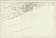
Yorkshire 240 - OS Six-Inch Map
1 : 10560 Topographic maps Ordnance Survey Ordnance Survey
TA02 - OS 1:25,000 Provisional Series Map
1 : 25000 Topographic maps Ordnance Survey Ordnance Survey
Kingston upon Hull (Hills) - OS One-Inch Revised New Series
1 : 63360 Topographic maps Ordnance Survey Ordnance Survey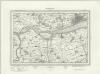
Kingston upon Hull (Outline) - OS One-Inch Revised New Series
1 : 63360 Topographic maps Ordnance Survey Ordnance Survey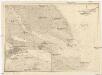
Nordsee
1 : 150000 Grimsby (Anglie) Reichs-Marine-Amt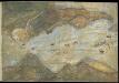
Humber from Hull and Barton to Sea
This is a map showing the River Humber, River Hull and the town of hull. It dates from between 1541-1547. The map is drawn in a loose pictorial style but despite this the defences of Hull are shown in accurate detail. These fortifications were built under the instruction of Henry VIII to protect the eastern side of the town. Plans for the building work were made in 1541 after the king visited in October of that year and dictated that the eastern side of the town, defended only by the River Hull, must be strengthened. At this time Henry VIII feared an invasion from the combined forces of France and Spain. In 1538 Francis I of France, and Charles V Holy Roman Emperor and King of Spain signed a peace treaty. This union gave rise to the possibility that France and Spain may combine forces to invade England. France was England’s historical enemy and Henry VIII’s divorce of Catherine of Aragon, Charles V’s aunt, had offended the militantly catholic King of Spain. The town of Hull, located on the east coast of the country, near the Anglo-Scottish border occupies a position of strategic importance as it provided a base for war against Scotland or Catholic Europe As can be seen here the fortifications at Hull consisted of two large trefoil headed blockhouses’ or bulwarks’ at opposite ends of the harbour, with a castle’ between them. Connecting these fortresses was a crenellated wall almost half a mile long running parallel to the river. This would provide defences which could protect against overland attack from the east, or naval invasion from the Humber. The draughtsman has accurately recorded the unusual trefoil shapes of the bulwarks, the segmental forms of the castle and the angled bend and crenellations of the connecting wall. In December 1543 costs were given as 21,056 5s. 6d in total. This chart could date from as early as October 1541, when the King visited Hull in October 1541 and expressed concern that the east side of the town was vulnerable to an attack.
Hull - OS One-Inch Map
1 : 63360 Topographic maps Ordnance Survey Ordnance Survey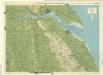
Lincoln Woods, Sheet 10 - Bartholomew's "Half Inch to the Mile Maps" of England & Wales
1 : 126720 Topographic maps Bartholomew, John George John Bartholomew & Co
Dvcatvs Eboracensis pars orientalis
1 Karte : Kupferdruck ; 36 x 48 cm Valck; Schenk ex typographia Gerardi Valk et Petri Schenk
Dvcatvs Eboracensis pars orientalis
1 Karte : Kupferdruck ; 37 x 49 cm Blaeu Joan Blaeu
DVCATVS | EBORACENSIS | PARS ORIENTALIS; | The Eastriding of Yorkeshire.
[Amsterdam : Joan Blaeu]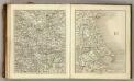
Sheets 51-52. (Cary's England, Wales, and Scotland).
1 : 360000 Cary, John, ca. 1754-1835
Ducatus Eboracensis Pars Orientalis. The Eastriding of Yorke Shire. [Karte], in: Novus atlas absolutissimus, Bd. 8, S. 38.
1 Karte aus Atlas Janssonius Offizin
Ducatus Eboracensis Pars Orientalis; The Eastriding of Yorkeshire. [Karte], in: Theatrum orbis terrarum, sive, Atlas novus, Bd. 4, S. 453.
1 Karte aus Atlas Blaeu, Joan Blaeu, Willem Janszoon
Ducatus Eboracensis Pars Orientalis; The Eastriding of Yorkeshire [Karte], in: Le théâtre du monde, ou, Nouvel atlas contenant les chartes et descriptions de tous les païs de la terre, Bd. 4, S. 391.
1 Karte aus Atlas Blaeu, Willem Janszoon und Blaeu, Joan Blaeu, Willem Janszoon
Ducatus Eboracensis Pars Orientalis; The Eastriding of Yorkeshire. [Karte], in: Theatrum orbis terrarum, sive, Atlas novus, Bd. 4, S. 453.
1 Karte aus Atlas Blaeu, Joan Blaeu, Willem Janszoon
Generalkarte von Zentraleuropa

An accurate map of Lincolnshire
1 Karte : Kupferdruck ; 68 x 51 cm Bowen; Hinton sold by J. Hinton at the Kings Arms in St. Pauls Church Yard