Maps of Wangdi Phodrang

Maps of Wangdi Phodrang

$title$

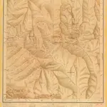
Bhutan, No 78 I, Tongsa

India And Adjacent Countries 1:253,440 or 1" = 4 miles maps Survey of India London : War Office
$title$

India and adjacent countries

1 : 1000000 Bangladéš Survey of India offices
$title$

Yamdrog Tsho

1 : 2500000 United States. Army Map Service. Army Map Service
$title$

Bhutan & Tibet, No 78 E, Punakha

India And Adjacent Countries 1:253,440 or 1" = 4 miles maps Survey of India
$title$

KARTE von ASSAM

1 : 1000000 Bhútán Berghaus, Heinrich Karl Wilhelm Brose, W. Justus Perthes
$title$

Karte von Assam und seinen Nachbar-Ländern

1 : 1000000 gest. von W. Brose u. W. Jaeck Gotha : Perthes
$title$

Assam et Boutan. Asie 84.

1 : 1641836 Vandermaelen, Philippe, 1795-1869
$title$

Karte von Asam, Ost-Bengalen und Nord-Birma

1 : 2275000 Bengálsko Mahlmann, Heinrich Etzel, Franz August von D. Reimer
$title$

The Province of Bengal

India Office reference collection of maps Survey of India
$title$

Bengal Etc.

1 : 3380000 Sharpe, J.
$title$

Provinces of the Lower Ganges.

1 : 2000000 John Bartholomew & Co.
$title$

The Province of Bengal and Assam

India Office reference collection of maps Survey of India
$title$

Bengal, Bahar, Oude, Allahabad.

1 : 1480000 Rennell, James, 1742-1830
$title$

Gangetic Hindoostan or the countries occupied by the Ganges and the branches

1 : 7000000 Cary, John, ca. 1754-1835 J. Cary
$title$

N. Hindostan.

1 : 1480000 Robert Laurie & James Whittle
$title$

Burma, OR 5574

One sheet within a four-sheet series, OR 5574, that contains both color and monochrome maps. Great Britain. War Office. [London] : [War Office]
$title$

$title$

India - north-eastern section.

1 : 4000000 John Bartholomew & Co.
$title$

(Hindoostan north)

1 : 2500000 Robert Laurie & James Whittle
$title$

Northern India Including The Presidency of Calcutta.

1 : 9000000 Tallis, J. & F.
$title$

[Undecima Asie tabula] [Karte], in: Clavdii Ptholomei Viri Alexandrini Cosmographie, S. 188.

1 Karte aus Atlas Nicolaus Germanus [und Ptolemaeus, Claudius]
$title$

India (northern sheet).

1 : 4457000 Johnston, W. & A.K.
$title$

N. Hindostan.

1 : 4400000 Thomson, John
$title$

India N.

1 : 4457000 Johnston, Alexander Keith, 1804-1871
$title$

India (northern sheet).

1 : 4457000 Johnston, Alexander Keith
$title$

137-138. North India, Nepal, East Pakistan. The World Atlas.

1 : 5000000 USSR (Union of Soviet Socialist Republics).
$title$

India (northern sheet).

1 : 4457000 Johnston, Alexander Keith
$title$

Inde N.-E. et Tibet.

1 : 5000000 Vivien St Martin, L.
$title$

Undecima Asie Tabula [Karte], in: [Clavdii Ptholomei Cosmographi ...], S. 332.

1 Karte aus Atlas Nicolaus Germanus [und Ptolemaeus, Claudius]
$title$

The East Indies, with the roads (northern section).

1 : 2600000 Jefferys, Thomas
© MapTiler © OpenStreetMap contributors
How does it work?
These instructions will show you how to find historical maps online.
Getting started
Type the place name in the search box to find the exact location. You can further adjust the search by zooming in and out.
Zoom
Zoom in and out with the buttons or use your mouse or touchpad natively.
Exact Area tool
Click here and draw a rectangle over the map to precisely define the search area.
Set filters
Narrow your search with advanced settings, such as Years (from/to), Fulltext, Publisher, etc.
Results
See the results of your search on the right side. You can scroll down to find more maps of this location.
?

Download OldMapsOnline Mobile