Maps of Wagenfeld

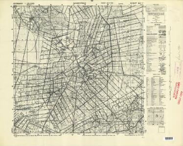
Germany 1:25,000, Wagenfeld
Germany 1:25,000 , Series GSGS 4414. Great Britain. War Office. [London] : War Office
Meßtischblatt 1808, neue Nr. 3417 : Wagenfeld, 1938
1 : 250000 Wagenfeld. - Hrsg 1899, einz. Nachtr. 1938. - 1:25000. - [Berlin]: Reichsamt für Landesaufnahme, 1938. - 1 Kt.
259. Diepholz.
1 : 100000 Reichsamt fur Landesaufnahme
Composite: 259. Diepholz.
1 : 100000 Reichsamt fur Landesaufnahme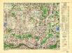
Germany/Central Europe 1:100,000, Minden
Germany / Central Europe 1:100,000, Series GSGS 4416. Great Britain. War Office. [London] : Ordnance Survey
72. Nienburg, uit: Topographische Uebersichtskarte des Deutschen Reiches / herausgegeben v. d. Kartogr. Abt. d. Königl. Preuß. Landesaufnahme
1 : 200000 titelvariant: Topogr. Übersichtskarte des Deutschen Reiches; Annotatie: Titel boven bladen ook: Topogr. Übersichtskarte des Deutschen Reiches; Annotatie geografische gegevens: Op elk blad twee maatstokken: 10 Kilometer = 5,5 cm; 1 geogr. Meile = 3,6 cm; Legenda onder op elk blad Königlich Preußische Landesaufnahme. Kartographische Abtheilung [S.l : Königlich Preußische Landesaufnahme, Kartographische Abtheilung]
Osnabrvgensis Episcopatvs
1 : 470000 Mollova mapová sbírka Gigas, Johann Michael Schenk, Peter I
Osnabrvgensis Episcopatvs
1 : 470000 Mollova mapová sbírka Gigas, Johann Michael
OSNABRVGENSIS | EPISCOPATVS
Auctore Ioanne Gigante. Amstelodami, | Guiljelm. Blaeuw | Excudit
Osnabrugensis Episcopatus. [Karte] Districtus Reckenbergensis. [Nebenkarte], in: Novus atlas absolutissimus, Bd. 2, S. 115.
1 Karte aus Atlas Janssonius Offizin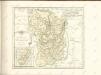
Osnabrugensis Episcopatus. [Karte] Districtus Reckenbergensis. [Nebenkarte], in: Le théâtre du monde, ou, Nouvel atlas contenant les chartes et descriptions de tous les païs de la terre, Bd. 1, S. 166.
1 Karte aus Atlas Blaeu, Willem Janszoon und Blaeu, Joan Blaeu, Willem Janszoon
Osnabrugensis Episcopatus. [Karte] Districtus Reckenbergensis. [Nebenkarte], in: Novus Atlas, das ist, Weltbeschreibung, Bd. 1, S. 135.
1 Karte aus Atlas Blaeu, Joan Blaeu, Willem Janszoon
Osnabrugensis Episcopatus. [Karte] Districtus Reckenbergensis. [Nebenkarte], in: Gerardi Mercatoris et I. Hondii Newer Atlas, oder, Grosses Weltbuch, Bd. 1, S. 170.
1 Karte aus Atlas Mercator, Gerhard und Hondius, Jodocus Jansson, Jan
Minden 57, uit: [W. Liebenow's Special-Karte von Mittel-Europa]
1 : 300000 titelvariant: W. Liebenow's Mittel-Europa; Annotatie: Titel boven de bladen: W. Liebenow's Mittel-Europa Johannes Wilhelm Liebenow 1822-1897 Hannover : Hermann Oppermann
Osnabrvgensis episcopatvs
1 : 236000 Osnabrück (Německo) Gigas, Johann Michael Blaeu, Willem Janszoon Guilielm Blaeuw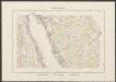
Osnabrugensis Episcopatus. [Karte] Districtus Reckenbergergensis. [1 Nebenkarte], in: Theatrum orbis terrarum, sive, Atlas novus, Bd. 1, S. 206.
1 Karte aus Atlas Blaeu, Joan Blaeu, Willem Janszoon
Minden 57, uit: Special-Karte von Mittel-Europa / nach amtlichen Quellen bearbeitet von W. Liebenow
1 : 300000 titelvariant: W. Liebenow's Mittel-Europa; Annotatie: Titel boven de bladen: W. Liebenow's Mittel-Europa Johannes Wilhelm Liebenow 1822-1897 Frankfurt a. M. : Ludwig Ravenstein
Le Theatre de Bellone :
Mollova mapová sbírka Schenk, Pieter Braakman, Adriaan
Carte topographique d'Allemagne
1 : 225000 Brémy (Německo) Jaeger, Johann Wilhelm Abraham Berndt, Johann Christoph I.W.A. Iaeger
L'Eveché de Munster Le Comté de Bentheim Tecklenbourg Stenford Lingen, Diepholtz Delmenhorst, Ritberg &c.
1 : 420000 Mollova mapová sbírka Le Rouge, Georges-Louis Le Rouge, Georges-Louis
Basse Partie de l'Evesché de Munster, et le Comté de Benthem
1 : 300000 Mollova mapová sbírka Sanson, Guillaume Mortier, Pierre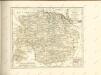

Basse Partie De L'Evesché De Munster, Et Le Comté De Benthem. [Karte], in: Atlas nouveau, contenant toutes les parties du monde [...], Bd. 1, S. 307.
1 Karte aus Atlas Sanson, Nicolas Jaillot, Alexis Hubert und Mortier, Pieter
Grossherzogthum Oldenburg und Gebiet der freien Stadt Bremen
Grosser Hand-Atlas über alle Theile der Erde in 170 Karten Meyer, J. Verlag des Bibliographischen Instituts
Monasteriensis et Osnabvrgensis episcopatvs descriptio
1 Karte : Kupferdruck ; 36 x 25 cm Mascop; Ortelius s.n.
Monasteriensis et Osnabvrgensis episcopatvs descriptio
1 Karte : Kupferdruck ; 25 x 36 cm Mascop; Ortelius s.n.
Königreich Hannover u. Herzogthum Oldenburg
1 : 380000 Aurich (Německo) Renner, Art. Frommann, Max.
Carte Nouvelle de l'Eveché de Munster
1 : 180000 Mollova mapová sbírka Grancourt