Maps of Samtgemeinde Gellersen

Maps of Samtgemeinde Gellersen

$title$

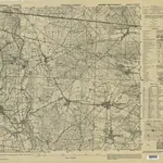
Germany 1:25,000, Kirchgellersen

Germany 1:25,000 , Series GSGS 4414. Great Britain. War Office. [London] : War Office
$title$

Meßtischblatt 1299 : Kirchgellersen, 1901

1 : 250000 Kirchgellersen. - Aufn. 1878/99. - 1:25000. - [Berlin]: Reichsamt für Landesaufnahme, 1901. - 1 Kt.
$title$

Composite: 178. Harburg. (Germany)

1 : 100000 Reichsamt fur Landesaufnahme
$title$

Composite: 209. Amelinghausen. (Germany)

1 : 100000 Reichsamt fur Landesaufnahme
$title$

209. Amelinghausen. (Germany)

1 : 100000 Reichsamt fur Landesaufnahme
$title$

178. Harburg. (Germany)

1 : 100000 Reichsamt fur Landesaufnahme
$title$

$title$

$title$

Lüneburg 45, uit: Special-Karte von Mittel-Europa / nach amtlichen Quellen bearbeitet von W. Liebenow

1 : 300000 titelvariant: W. Liebenow's Mittel-Europa; Annotatie: Titel boven de bladen: W. Liebenow's Mittel-Europa Johannes Wilhelm Liebenow 1822-1897 Frankfurt a. M. : Ludwig Ravenstein
$title$

Lüneburg 45, uit: [W. Liebenow's Special-Karte von Mittel-Europa]

1 : 300000 titelvariant: W. Liebenow's Mittel-Europa; Annotatie: Titel boven de bladen: W. Liebenow's Mittel-Europa Johannes Wilhelm Liebenow 1822-1897 Hannover : Hermann Oppermann
$title$

Typus Geographicus Ducat. Lauenburgici Novus

1 : 270000 Mollova mapová sbírka Homann, Johann Christoph Schneider, Ruprecht Adam Homann, Johann Baptista - dědici
$title$

Le Theatre de Bellone :

Mollova mapová sbírka Schenk, Pieter Braakman, Adriaan
$title$

$title$

Das Hertzogthum Bremen nebst dem Stifft oder Fürstenthum Verden im Nieder Sächsischen Creiss

1 : 750000 Mollova mapová sbírka Weigel, Johann Christoph Weigel, Johann Christoph
$title$

Le Duché de Bremen et Ferden

1 : 370000 Mollova mapová sbírka Le Rouge, Georges-Louis Le Rouge, Georges-Louis
$title$

$title$

[46][46] Ducatus Bremae & Ferdae ..., uit: Atlas sive Descriptio terrarum orbis

Annotatie: Gedigitaliseerde versie. Amsterdam. Heiloo : Picturae (vervaardiger), 2015. tiff-bestand. Gedigitaliseerd: 07-01-2015; Origineel: Universiteitsbibliotheek Vrije Universiteit (XL.05127.-) ; Netherlands; Titelpagina ontbreekt Wit, Frederik de Amsterdam : Frederick de Wit
$title$

$title$

DUCATUS BREMAE et FERDAE, Maximaeque partis DUCATUS STORMARIAE, COMITATUS OLDENBURGI, ALBIS, VISURGISQUE FLUMINUM Novissima Descriptio

1 : 330000 Labe-oblast (Česko a Německo) Visscher, Nicolaus per Nicolaum Visscher
$title$

Ducatus Bremae et Ferdae nova tabula

1 : 370000 Brémy (Německo : spolková země) Homann, Johann Baptist â Ioh. Bapt. Homanno
$title$

Ducatus Bremae et Ferdae nova tabula

1 : 370000 Brémy (Německo : spolková země) Homann, Johann Baptist â Ioh. Bapt. Homanno
$title$

Ducatus Luneburgicus cum comitatu Dannebergensi

1 : 336000 Lüneburg (Německo) Seutter, Matthäus Matth. Seutter
$title$

$title$

Ducatus Luneburgici et comitatus Dannenbergensis

1 : 363000 Lüneburg (Německo) Visscher, Nicolaus Schenk, Pieter Pet. Schenk Iun.
$title$

Ducatus Luneburgici et comitaus Dannebergensis accurata descriptio

1 : 380000 Dolní Sasko (Německo) Homann, Johann Baptist J. B. Homann
$title$

Ducatus Bremae & Ferdae Maximaeque partis Fluminis Visurgis

1 : 360000 Mollova mapová sbírka Wit, Frederik de Mortier, Cornelis
$title$

Ducatus Bremae & Ferdae Maximaeque partis Fluminis Visurgis

1 : 320000 Mollova mapová sbírka Wit, Frederik de Covens, Johannes I
$title$

Ducatus Bremae & Ferdae Maximaeque partis Fluminis Visurgis

1 : 360000 Mollova mapová sbírka Danckerts, Cornelis Danckerts, Cornelis
$title$

Ducatus Lunenburgensis in omnes ejusdem subjacentes praefecturas Nova descriptio

1 : 870000 Mollova mapová sbírka Danckerts, Justus Danckerts, Justus
$title$

HOLSATIAE TABULA GENERALIS in qua sunt DUCATUS HOLSATIAE, DITHMARSIAE STORMARIAE et WAGRIAE

1 : 310000 Holštýnsko Wit, Frederick de Frederic de Wit
© MapTiler © OpenStreetMap contributors
How does it work?
These instructions will show you how to find historical maps online.
Getting started
Type the place name in the search box to find the exact location. You can further adjust the search by zooming in and out.
Zoom
Zoom in and out with the buttons or use your mouse or touchpad natively.
Exact Area tool
Click here and draw a rectangle over the map to precisely define the search area.
Set filters
Narrow your search with advanced settings, such as Years (from/to), Fulltext, Publisher, etc.
Results
See the results of your search on the right side. You can scroll down to find more maps of this location.
?

Download OldMapsOnline Mobile