Maps of Cherbourg

Maps of Cherbourg

$title$

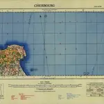
France 1:250,000, Cherbourg

Sheet 3a of the 40-sheet map series, France 1:250 000, Series GSGS 2738. Great Britain. General Staff. Geographical Section. [London] : [GSGS, War Office]
$title$

[Cherbourg]

1 Blatt : 60 x 91 cm s.n.
$title$

125 Cherbourg.

1 : 86400 Cassini family; Cassini, Cesar-Francois, 1714-1784
$title$

Capitaineries garde costes de Barfleur Retauville et partie de celle de Cherbourg

1 Karte : 22 x 32 cm de Fer
$title$

[La Hougue]

1 Blatt : 60 x 47 cm Seguin; Le Roy s.n.
$title$

93 La Hougue.

1 : 86400 Cassini family; Cassini, Cesar-Francois, 1714-1784
$title$

Carte topographique du port et de la Ville de Cherbourg et de ses environs

1 : 30000 levées sur les lieux par J.G.B. Ingenieur geographe, 1787
$title$

Carte topographique du port et de la ville de Cherbourg et de ses environs

1 Karte : Kupferdruck ; 49 x 71 cm s.n.
$title$

Vues & coupes du Cap de la Heve

Francie Sociéte Géologique de Normandie
$title$

A genuine plan of Cherburg with the fortifications, as intended to be finished according to the design of Mr. De Caux

1 : 1
$title$

Havre de Grace : cette ville est une des plus fortes de l'Europe ...

1 : 6000 [S.l. : s.n.]
$title$

Der Kanal

1 : 150000 Francie Reichs-Marine-Amt
$title$

Département de la Manche

1 Karte : Kupferdruck ; 60 x 40 cm au bureau de l'atlas national rue de la Harpe n.o 26, et au dépost de cet atlas rue de la Monnoie n.o 5
$title$

Dept. De La Manche.

1 : 455000 Levasseur, Victor.
$title$

Diocese de Coutances, [feuille 2 et 4]

2 Blätter : Dezauche
$title$

Een gedeelte van het Kanaal van Cherborgh tot t eijland Jerseij

France Gerard van Keulen
$title$

Capitaineries garde costes de Grais Port S.te Honorine Grand Camp Carentan et de la Hougue

1 Karte : 22 x 33 cm de Fer
$title$

Capitaineries garde costes de Port Bail Coutenville et partie de celle de Cherbourg

1 Karte : 22 x 32 cm de Fer
$title$

France 1:50,000 , Series GSGS 4250, Creully

France 1:50,000 , Series GSGS 4250. Great Britain. War Office. General Staff. Geographical Section. [London] : Ordnance Survey
$title$

France, 1:25,000, GSGS 4347 [Defence O/P], Ste Mere Eglise

France, 1:25,000, GSGS 4347 [Defence O/P]. Defence overprinted in blue, red and purple on GSGS 4347. -- Mixture of 'Bigot' and non-'Bigot' sheets. Most sheets marked 'Defences'. -- Includes various editions. -- Sheets show German defences in Normandy. Great Britain. War Office. [London] : War Office
$title$

Northwestern Normandy : natural regions

1 : 550000 Provisional ed. Relief shown by shading. "Map no. 2369, 8 July 1943." "Restricted." "Reliability code: 00--2B--2." United States. Office of Strategic Services. Research and Analysis Branch [Washington, D.C.] : R & A, OSS
$title$

Carte de la Normandie

1 Karte auf 2 Blättern : Kupferdruck ; 62 x 96 cm Legendre; Lattré chez Lattré graveur ordinaire du roi de M. le Duc d'Orleans et de la ville rue St. Jacques a la ville de Bordeaux
$title$

Gouvernement de Normandie

1 Karte auf 4 Blättern : Kupferdruck ; 60 x 82 cm Mentelle; Tardieu; Macquet Mentelle
$title$

Composite 4: Carte de France.

1 : 86400 Cassini family; Cassini, Cesar-Francois, 1714-1784
$title$

Normandia Ducatus. [Karte], in: Le théâtre du monde, ou, Nouvel atlas contenant les chartes et descriptions de tous les païs de la terre, Bd. 2, S. 120.

1 Karte aus Atlas Blaeu, Willem Janszoon und Blaeu, Joan Blaeu, Willem Janszoon
$title$

N.W. Normandy : fisheries

1 : 880000 Provisional ed. "Map no. 2324." "19 July 1943." Includes location map. United States. Office of Strategic Services. Research and Analysis Branch [Washington, D.C.] : R & A, OSS
$title$

Normandia ducatus

1 Karte : Kupferdruck ; 37 x 51 cm Janssonius Joannes Janssonius
$title$

Normandia Ducatus. [Karte], in: Theatrum orbis terrarum, sive, Atlas novus, Bd. 2, S. 74.

1 Karte aus Atlas Blaeu, Joan Blaeu, Willem Janszoon
$title$

Coast of France : Dieppe to St. Brieuc

1 : 885000 Provisional ed. Inset: [Location map]. Shows main roads and railroads. Dated: 12 June 1944. United States. Office of Strategic Services. Research and Analysis Branch [Washington, D.C.] : R & A, OSS
$title$

Carte de la France, no. 4

1 Blatt : 61 x 92 cm s.n.
© MapTiler © OpenStreetMap contributors
How does it work?
These instructions will show you how to find historical maps online.
Getting started
Type the place name in the search box to find the exact location. You can further adjust the search by zooming in and out.
Zoom
Zoom in and out with the buttons or use your mouse or touchpad natively.
Exact Area tool
Click here and draw a rectangle over the map to precisely define the search area.
Set filters
Narrow your search with advanced settings, such as Years (from/to), Fulltext, Publisher, etc.
Results
See the results of your search on the right side. You can scroll down to find more maps of this location.
?

Download OldMapsOnline Mobile