Maps of Al Butnan
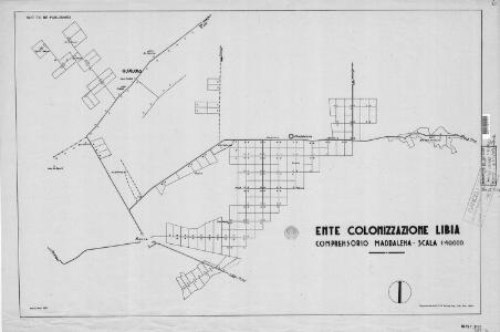
Cyrenaica, Lybia, Maddalena
Ente Colonizzazione Libia, comprensorio [district]. One of a collection of maps of districts in Libya; reproduced from Italian originals. [S.l.] : 512 Fd. Survey Co. R.E.
Egypt and Cyrenaica 1:250,000, Salum-Torbruch
Egypt and Cyrenaica 1:250,000 , Series GSGS 4386. Great Britain. Army. Middle East Command. [London] : War Office
Tripoli, Egypt.
1 : 2000000 Society for the Diffusion of Useful Knowledge (Great Britain)
Carte De La Mer Mediterranee. IX.
Roux, Joseph
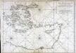
Partie, l'Egypte. Afrique 5.
1 : 1641836 Vandermaelen, Philippe, 1795-1869
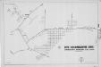
Eastern Libya, Aerodrome Map
Aerodrome map of Eastern Libya, DR 326. Great Britain. Army. Royal Engineers. Field Survey Company, 512th. [Cairo] : [Survey Directorate, Middle East]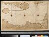
De kuste van Egipten en Barbaria beginnende van Jaffa tot I: Soliman int groot
Egypt Gerard van Keulen
Feuille 47 (E VII), uit: Carte géologique internationale de l'Europe : la carte, votée au congrès géologique international de Bologne en 1881, est exécutée conformément aux décisions d'une commission internationale, avec le concours des gouvernements, sous le dir. de M.M. Beyrich et Hauchecorne
Annotatie: Blad 48 gamme des couleurs; blad 49: bladwijzer en titelblad Heinrich Ernst Beyrich 1815-1896; Wi. Hauchecorne Berlin : Reimer / (Berlin: Institut lithographique)
Africa 1:2.000.000, Cyrenaica
Cyrenaica, Libya
Map of Egypt
1 : 2000000 Alexandrie (Egypt) E. Stanford
Aegypten und Sues-Canal
1 : 3500000 Egypt Justus Perthes
[XXIV], uit: Geognostische Karte des Oesterreichischen Kaiserstaates mit einem grossen Theile Deutschland's u. Italien / hauptsachlich nach ... Haidinger's geognostischer Karte dieses Staates bearb. von Josef Scheda
1 : 3000000 titelvariant: General-Karte von Europa in 25 Blättern; Annotatie: Bijlage bij: General-Karte von Europa in 25 Blättern. - 1:2.592.000. - 1845-1847 Scheda, Joseph Wien : K.K. Militär. Geografisch. Institut
Carte historique, physique & politique de l'Égypte
1 : 1210000 Alexandrie (Egypt) Lapie, Ch. Buckhardt chez Ch. Picquet
Aegyptus et Arabia Petraea
1 : 1980000 Arabský poloostrov Reichard, Christian Gottlieb Campius, D. D. Campio
Egypt a průplav Suezský
1 : 3700000 Egypt
[Kaart], uit: Aegypten und Sues-Canal
1 : 3500000 titelvariant: Oorlogskaart; Egypte en Suez-kanaal; Annotatie: In omslag met titel: Oorlogskaart : Egypte en Suez-kanaal. - Amsterdam : Seyffardt, 1882; Annotatie geografische gegevens: Aangegeven zijn vaarroutes over de Middellandse Zee en de Rode Zee; Inzetkrt.: Nil-Delta und Landenge von Sues. - 1:1.500.000; [Noord-Afrika, West-Azië, Zuid-Europa] Gotha : Justus Perthes
Aegyptus
1 : 3000000 Egypt Bonne, Rigobert André
Die asiatische Türkei...
Carte de la mer Mediterranée, 3
1 Blatt : 51 x 74 cm s.n.
115. Egitto.
1 : 5000000 Touring club italiano
Aegypten
Neuester Schul-Atlas Walch, Johann im Verlag bei Joh. Walch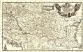
Eigentliche Vorstellung des so berühmten König: Reichs Ungarn neben Sibenbürgen, Moldau, Wallachey, Posnien und andern Ländern mehr bis an Constantinopel
1 : 1900000 Mollova mapová sbírka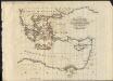
General outline of the Authors route as adapted to the second section of part the second of these travels
1 : 1
Ancient Africa or Libya II.
1 : 5100000 Society for the Diffusion of Useful Knowledge (Great Britain)
Carte reduite de la Mer Mediterranée, 2
1 Blatt : 59 x 51 cm ; s.n.
Klein-Asien & Syrien nebst den westlichen Theilen von Armenien, Kurdistan & Mesopotamien
Hand-Atlas über alle Theile der Erde und über das Weltgebäude Stieler, Adolf Justus Perthes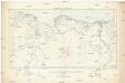
Tripoli & Egypt
1 : 3000000 Egypt E. Stanford
Tabula geographica Cyri et Xenophontis expeditionem illustrans
1 : 8000000 Annotatie: Historische kaart van de tocht van Xenophon en de "Tienduizend" door het Perzische Rijk (401 v.Chr.) Leiden : Brill
Carte reduite de la Mer Mediterranée, 3
1 Blatt : 59 x 51 cm ; s.n.