Maps of Toul
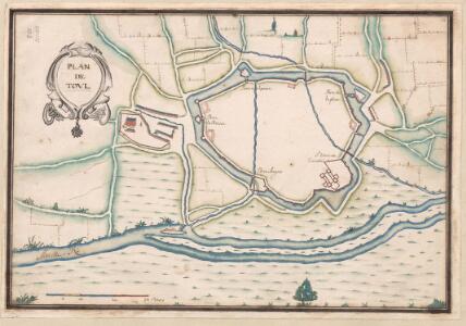
A colored plan of the fortifications of Toul
A colored manuscript plan of the fortifications of Toul in Lorraine, France; drawn about 1650, on a scale of 100 toises to an inch.
111 Toul.
1 : 86400 Cassini family; Cassini, Cesar-Francois, 1714-1784
167. Solgne, uit: Topographische Uebersichtskarte des Deutschen Reiches / herausgegeben v. d. Kartogr. Abt. d. Königl. Preuß. Landesaufnahme
1 : 200000 titelvariant: Topogr. Übersichtskarte des Deutschen Reiches; Annotatie: Titel boven bladen ook: Topogr. Übersichtskarte des Deutschen Reiches; Annotatie geografische gegevens: Op elk blad twee maatstokken: 10 Kilometer = 5,5 cm; 1 geogr. Meile = 3,6 cm; Legenda onder op elk blad Königlich Preußische Landesaufnahme. Kartographische Abtheilung [S.l : Königlich Preußische Landesaufnahme, Kartographische Abtheilung]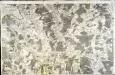
[Verdun]
1 Blatt : 60 x 91 cm Seguin s.n.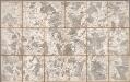
No. 111 (41) [Bar-le-Duc, Commercy, Toul], uit: Carte géométrique de la France dite "Carte de Cassini" ou "de l'Académie"
1 : 86400 titelvariant: Carte de Cassini; Annotatie: Incompleet; Voor aanwezige bladen zie overzichtsblad Cassini de Thury, C.-F. Paris : [s.n.]
Les Environs de la Ville de Nancy Capitale du Duché de Lorraine ou se trouve ce qui depend de son Office, Chatellenie, Balliage et Banlieue
1 : 140000 Mollova mapová sbírka Ville de Courtenayn, de Nolin, Jean Baptiste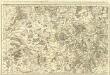
Le Toulois ou sont Les Catellenies et Les Prevotés du Temporel del'Eveché de Toul et deson Chapitre :
1 : 180000 Mollova mapová sbírka Jaillot, Alexis-Hubert Jaillot, Alexis Hubert
Umgegend von Metz
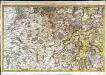
Le Toulois
1 Karte : Kupferdruck ; 43 x 68 cm Jaillot Alexis-Hubert Jaillot
Departement de la Meurte
1 Karte : Kupferdruck ; 17 x 16 cm au dépot de l'Atlas national rue de la Monnoye no. 5
Archidia.connés De Tovl, De Ligny, et Reynel, Dans l'Evesché De Tovl
1 : 240000 Mollova mapová sbírka Sanson, Nicolas Somer, Jean Pruthenus Sanson, Nicolas
Mediomatrici
1 Karte : Kupferdruck ; 41 x 48 cm Sanson; Mariette chez P. Mariette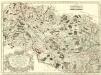
Archidiacnés de Port, et Prevosté de St. Diey, dans l'Evesché de Tovl
1 : 240000 Mollova mapová sbírka Sanson, Nicolas Mariette, Pierre Sanson, Nicolas II
Lorraine
1 : 317000 Lotrinsko (Francie)
Bar le Duc 125, uit: [W. Liebenow's Special-Karte von Mittel-Europa]
1 : 300000 titelvariant: W. Liebenow's Mittel-Europa; Annotatie: Titel boven de bladen: W. Liebenow's Mittel-Europa Johannes Wilhelm Liebenow 1822-1897 Hannover : Hermann Oppermann
Bar le Duc 125, uit: Special-Karte von Mittel-Europa / nach amtlichen Quellen bearbeitet von W. Liebenow
1 : 300000 titelvariant: W. Liebenow's Mittel-Europa; Annotatie: Titel boven de bladen: W. Liebenow's Mittel-Europa Johannes Wilhelm Liebenow 1822-1897 Frankfurt a. M. : Ludwig Ravenstein
Levci
1 Karte : Kupferdruck ; 41 x 56 cm Sanson; Robert de Vaugondy chés le Sr. Robert g. du roi quai de l'horloge
Mediomatrici
1 Karte : Kupferdruck ; 41 x 48 cm Sanson; Robert de Vaugondy ches le Sr. Robert geog. du roi quai de l'horloge
Leuci
1 Karte : Kupferdruck ; 41 x 48 cm Sanson; Robert de Vaugondy; Somer chés le Sr. Robert geographe ord. du roi quai de l'horloge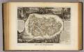
Dept. De La Meurthe.
1 : 395000 Levasseur, Victor.
Dept. De La Meuse.
1 : 579000 Levasseur, Victor.
Leuci
1 Karte : Kupferdruck ; 41 x 48 cm Sanson; Somer chez l'autheur
Département de la Meuse
1 Karte : Kupferdruck ; 41 x 32 cm Capitaine s.n.
Departement de la Meuse
1 Karte : Kupferdruck ; 49 x 48 cm Houdan au bureau de l'atlas national rue de la Harpe no. 26, et au dépôt du dit atlas rue de la Monnoye no. 5
Leuci
1 Karte : Kupferdruck ; 41 x 56 cm Sanson; Robert de Vaugondy chés le Sr. Robert g. o. du roi quai de l'horloge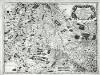
Leuci
1 Karte : Kupferdruck ; 41 x 56 cm Sanson; Mariette chez P. Mariette
[Atlas départemental : La France et ses colonies] No. 53 Meurthe
1 : 670000 publ. par Michel fils ainé [dressé par A. Lorrain, et gravé par H. Dandeleux] Versailles [etc.] : Barreswil et Andrieux
Département de la Meurte
1 Karte : Kupferdruck ; 48 x 48 cm Houdan au bureau de l'atlas national rue de la Harpe no. 26, et au dépôt du dit atlas rue de la Monnoye no. 5
[Lothringen, südlicher Teil]
1 Karte : Kupferdruck ; 35 x 46 cm Mercator; Hondius Henricus Hondius
[Lothringen, südlicher Teil]
1 Karte : Kupferdruck ; 35 x 46 cm Mercator; Hondius Jodocus Hondius