Maps of Wissembourg
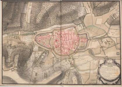
A colored "plan de Weissembourg
A colored, 18th-century manuscript plan of Weissembourg in Alsace, France, "distinguishing the fortifications completed from those unfinished; drawn in 1751, on a scale of 50 toises to an inch."
Meßtischblatt 3573 : Weissenburg, 1883
1 : 250000 Weissenburg. - Aufn. 1882. - 1:25000. - [Berlin]: Reichsamt für Landesaufnahme, 1883. - 1 Kt.
Les environs de Landau
1 Karte : Kupferdruck ; 23 x 33 cm Fer; Inselin Nicolas de Fer
Geographica Provinciarum Sveviae Descriptio =
Mollova mapová sbírka Hurter, Johann Christoph Bodenehr, Gabriel
Le cours du Rhin de Bâle à Hert près Philisbourg contenant l'Alsace et partie du Brisgau, 5
1 Blatt : 77 x 52 cm Le Rouge
161 Landau, Wissembourg.
1 : 86400 Cassini family; Cassini, Cesar-Francois, 1714-1784
Le Flambeau de la Guerre Allumee au Rhin
Mollova mapová sbírka Delisle, Guillaume Schenk, Peter II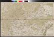
Carte über den groesten Theil des untern Elsasses, nebst der Grenze von Teutschland und Lotharingen. &c.
Bechstatt, I. C.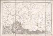
Wissembourg / réd. et gravée au Dépôt général de la Guerre sous la dir. de Pelet
1 : 80000 Pelet, Jean Jacques Germaine; Dépôt de la Guerre [Paris : Dépôt de la Guerre]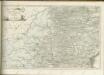
Landau mitt umbliegenden dörfferen und Stätten
1 : 170000 Mollova mapová sbírka Person, Nikolaus Person, Nicolas
160. Landau, uit: Topographische Uebersichtskarte des Deutschen Reiches / herausgegeben v. d. Kartogr. Abt. d. Königl. Preuß. Landesaufnahme
1 : 200000 titelvariant: Topogr. Übersichtskarte des Deutschen Reiches; Annotatie: Titel boven bladen ook: Topogr. Übersichtskarte des Deutschen Reiches; Annotatie geografische gegevens: Op elk blad twee maatstokken: 10 Kilometer = 5,5 cm; 1 geogr. Meile = 3,6 cm; Legenda onder op elk blad Königlich Preußische Landesaufnahme. Kartographische Abtheilung [S.l : Königlich Preußische Landesaufnahme, Kartographische Abtheilung]
[Landau - Wissembourg]
1 Blatt : 60 x 90 cm Brunet s.n.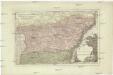
Der District Hagenau
1 : 182000 Haguenau (Francie)
Alasatia superior et inferior III. tabulis delineata, 3
1 Blatt : 62 x 59 cm s.n.
Carte Particuliere de Pays qui sont situéz entre le Rhein, la Saare, la Moselle, et la Basse Alsace
1 : 150000 Mollova mapová sbírka Jaillot, Alexis-Hubert Jaillot, Alexis Hubert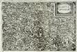
Alsatia inferior
1 Karte : Kupferdruck ; 14 x 22 cm Lambert Andreae
Charte von der Grafschaft Hanau-Lichtenberg
1 : 180000 Grattenauer, Ernst C. Grattenauer
Partie du Cours du Rhein, ou se Trouvent les Villes de Spire Philipsbourg Landau Hagenau et le Fort Louis, Dessigne et Levee sur les Lieues
1 : 160000 Mollova mapová sbírka Baillieul, Gaspard Bailleul, Gaspard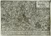
Alsatia inferior
1 Karte : Kupferdruck ; 17 x 27 cm Specklin; Quad Johannes Bussemacher
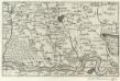
Carte Particuliere des Pays qui sont situéz entre le Rhein, la Saare, la Moselle, et la Basse Alsace
1 : 150000 Mollova mapová sbírka Mortier, Pieter Mortier, Pierre
Territorium Seculare Episcopatvs Spirensis una cum terris adiacentibus
1 : 140000 Mollova mapová sbírka Blödtner, Cyriak Homann, Johann Baptista - dědici
Specialkarte Der Gegenden Zwischen Dem Rhein Und Der Saar
1 : 170000 Rheinwald, Johann Ludwig Christian; Dewarat, Peter; Walbert
Strassburg 127, uit: Special-Karte von Mittel-Europa / nach amtlichen Quellen bearbeitet von W. Liebenow
1 : 300000 titelvariant: W. Liebenow's Mittel-Europa; Annotatie: Titel boven de bladen: W. Liebenow's Mittel-Europa Johannes Wilhelm Liebenow 1822-1897 Frankfurt a. M. : Ludwig Ravenstein
Strasburg 127, uit: [W. Liebenow's Special-Karte von Mittel-Europa]
1 : 300000 titelvariant: W. Liebenow's Mittel-Europa; Annotatie: Titel boven de bladen: W. Liebenow's Mittel-Europa Johannes Wilhelm Liebenow 1822-1897 Hannover : Hermann Oppermann
Kriegs-Theatrum.
Mollova mapová sbírka Lidl, Johann Jakob Lidl, Johann Jacob

Suevia universa IX. tabulis delineata, 1
1 Blatt : s.n.
Alsatia tem Svperior, quam Inferior una cum Svndgovia
1 : 120000 Mollova mapová sbírka Homann, Johann Baptist Homann, Johann Baptista - dědici