Maps of San Andrés y Providencia
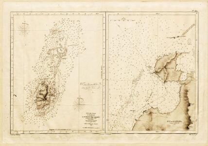
PROVIDENCIA, Caribbean Sea (Island) 1840 (1912)
La Vieille Providencia. Levée en 1835 par le Comr. R. Oweu. [Paris]
O.P. Island and Coral Bank (Catalina Harbour)
O.P. Island and Coral Bank (Catalina Harbour). Surveyed in ... 1835. [Admiralty Chart] London
PROVIDENCIA, Caribbean Sea (Island) 1840 (1912)
[O.P. Island and Coral Bank (Catalina Harbour). Surveyed in ... 1835. [Admiralty Chart]
Dept. del Ismo.
1 : 2750000 Restrepo, Jose Manuel, 1781-1863
Grandes Antilles. Amer. Sep. 73.
1 : 1641836 Vandermaelen, Philippe, 1795-1869
Jamaica, Cape Gracias a Dios.
1 : 1560000 Jefferys, Thomas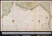
De custen van St. Marth Cartagena Darien, Tierra Firma en Costa Rica : van Caap Auga tot t Lac Nicaragua
Panama Gerard van Keulen
The Isthmus of Panama with the coast from Great River on the Moskito shore to Cartagena
1 : 1500000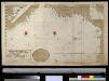
De kust van Carthagena, Tierra Firma, Costa Rica en de Honduras van Rio Grande de St. Martha tot Baija Honda int groot
Panama Gerard van Keulen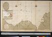
Nieuwen afteekening van de kust van Cartagena en Portobello beginnende van Santo Martha tot Rio Carabaca met allen desselfs havens baijen revieren eijlanden droogtens en dieptens Ao 1729
Panama Davelaar Johannes van Keulen
Carte Particuliere De Isthmus, Ou Darien, Qui comprend le Golfe De Panama &c. Cartagene, et les Isles Aux Environs. [Karte], in: Atlas nouveau, contenant toutes les parties du monde [...], Bd. 2, S. 243.
1 Karte aus Atlas Sanson, Nicolas Jaillot, Alexis Hubert und Mortier, Pieter
Central America.
1 : 5068800 Colton, G.W.
Central America
1 : 3800000 Mitchell, Samuel Augustus
Central America
1 : 3800000 Mitchell, Samuel Augustus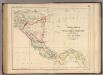
Central America.
1 : 3453120 Rogers, Henry Darwin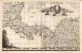
A Map of the British Empire in America. (Sheet 18).
1 : 2000000 Popple, Henry
Spanish dominions in North America, southern part.
1 : 2400000 Pinkerton, John, 1758-1826
Central America. Dominion of Canada and Newfoundland.
1 : 4440000 Hammond, C.S.
Central America.
1 : 2471000 Rand McNally and Company
Central America.
1 : 2500000 Rand McNally and Company
Central America.
1 : 5000000 Rand McNally and Company
Nova Isthmi Americani, qui et Panamiensis item Dariensis Tabula
Solo algunos mapas impresos por los hermanos Reinier y Josua Ottens llevan su impronta. Para armar sus atlas, los Ottens solían simplemente copiar o reimprimir mapas de otros cartógrafos holandeses y franceses. Este mapa del Istmo de Panamá evidencia, en cambio, adaptaciones y mejoras significativas de los Ottens a la Carte Particuliere De Isthmus ou Darien publicada por Pierre Mortier en 1700, poniendo particular énfasis en las islas, islotes, cayos, bajos, arenas, etc., del litoral centroamericano, así como en el relieve y la hidrografía del istmo y del continente. Ottens, R. (Reinier) (1698-1750); Ottens, J. (Josua) (1704-1765).
Central America.
1 : 5600000 Schlitz Brewing Company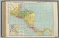
Central America.
1 : 2648000 Rand McNally and Company
Spanish North America, southern part
1 : 2800000
Map of Central America including the states of Guatemala, Salvador, Honduras, Nicaragua & Costa-Rica, the territories of Belise & Mosquito, with parts of Mexico, Yucatan & New Granada : shewing the proposed routes between the Atlantic & Pacific oceans by way of Tehuantepeque, Nicaragua & Panama
1 : 2100000 Baily, John, fl. 1811-1850 Saunders and Stanford
Central America.
1 : 5200000 Colton, G.W.
Terra Firma et Novum Regnum Granatense et Popayan. [Karte], in: Theatrum orbis terrarum, sive, Atlas novus, Bd. 2, S. 338.
1 Karte aus Atlas Blaeu, Joan Blaeu, Willem Janszoon
Terra Firma et. Novum Regnum Granatense et. Popayan [Karte], in: Gerardi Mercatoris et I. Hondii Newer Atlas, oder, Grosses Weltbuch, Bd. 2, S. 398.
1 Karte aus Atlas Mercator, Gerhard und Hondius, Jodocus Jansson, Jan