Maps of Palawan

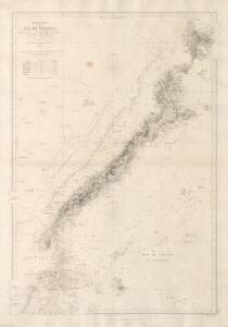
Mer de Chine Ile de Palawan
[Mer de Chine. Île de Palawan, d'après les travaux du Capite W.T. Bate et autres Officiers de la Marine Royale Anglaise et d'après divers documents étrangers] Paris
[Islas filipinas - Norte de Paragua]
Atlas de Filipinas Algué, P. José Government Printing Office
[Islas filipinas - Sur de Paragua, Balábac]
Atlas de Filipinas Algué, P. José Government Printing Office
No. 25. Sur de Paragua, Balabac.
1 : 815000 U.S. Coast and Geodetic Survey
No. 24. Norte de Paragua.
1 : 147000 U.S. Coast and Geodetic Survey
P. Kalampunian / compilation: LHQ Cartographic Coy., Aust. Svy. Corps
Australian Survey Corps . LHQ Cartographic Company [S.l.] : LHQ Cartographic Coy
Tg. Indarasan / compilation: LHQ Cartographic Coy., Aust. Svy. Corps
Australian Survey Corps . LHQ Cartographic Company [S.l.] : LHQ Cartographic Coy
Batumandi Rock / compilation: LHQ Cartographic Coy., Aust. Svy. Corps
Australian Survey Corps . LHQ Cartographic Company [S.l.] : LHQ Cartographic Coy
Sooloo Sea, Archipelago.
1 : 3600000 United States Exploring Expedition (1838-1842)
[Islas Filipinas, Segunda Hoja Central]
1 : 1000000 Morata, Antonio [Verlag nicht ermittelbar]
Islas Filipinas, 2a hoja / por el teniente coronel de ingenieros D. Francisco Coello ; las notas estadisticas e historicas han sido escritas por D. Pascual Madoz
1 : 1000000 1 full d'un mapa en tres fulls, b/n. Dins: Atlas de España y sus posesiones de ultramar Coello, Francisco ; Madoz, Pascual [Imprenta del Atlas de España]
Partie, Iles Philippines. Oceanique no. 6.
1 : 1641836 Vandermaelen, Philippe, 1795-1869
Kudat / compilation: LHQ Cartographic Coy., Aust. Svy. Corps
Australian Survey Corps . LHQ Cartographic Company [S.l.] : LHQ Cartographic Coy
Philippine Islands.
1 : 2471000 Rand McNally and Company
Borneo.
1 : 3168000 Stanford, Edward
127. Philippines. The World Atlas.
1 : 5000000 USSR (Union of Soviet Socialist Republics).
Chart of the Philippine Islands, from the Spanish chart in 1808, the adjacent islands are added from the lastest surveys
1 : 1660000 Arrowsmith, Arron Arrowsmith, Aaron
No. 2. Mapa General.
1 : 6000000 U.S. Coast and Geodetic Survey
Reduzirte Karte von den Philippinen und den Sulu-Inseln
1 : 2356000 den Manen Don Alexandro ́s Malaspina, Espinosa y Tello's, [...] Don Ildefonso de Aragon gewidmet vom Verfasser [H. Berghaus] gest. v. Selmar Siebert Gotha : Perthes
[Islas filipinas - distribution de temblores]
Atlas de Filipinas Algué, P. José Government Printing Office
[Islas filipinas - estaciones meteorologico-seismicas]
Atlas de Filipinas Algué, P. José Government Printing Office
[Islas filipinas - mapa general]
Atlas de Filipinas Algué, P. José Government Printing Office
No. 3. Mapa Etnografico.
1 : 6000000 U.S. Coast and Geodetic Survey
No. 4. Mapa Orografico.
1 : 6000000 U.S. Coast and Geodetic Survey
Mapa de las Islas Filipinas : formado expresamente para "El Correo Espaÿûnol" / por el topografo D. José Mendez
Madrid : Mendez
[Islas filipinas - mapa orografico]
Atlas de Filipinas Algué, P. José Government Printing Office
[Islas filipinas - mapa etnografico]
Atlas de Filipinas Algué, P. José Government Printing Office
Archipiélago de Filipinas: regalo a los Sres. suscriptores de la Crónica de la guerra de Cuba y de la rebelión de las Filipinas, Año 1896 / Passo
1 mapa. Casa Editorial Maucci, Asalto 8, Barcelona. Passo Casa Editorial Maucci
No. 5. Estaciones Meteorologico-Seismicas.
1 : 6000000 U.S. Coast and Geodetic Survey