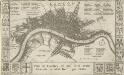
Maps of Tower Hamlets
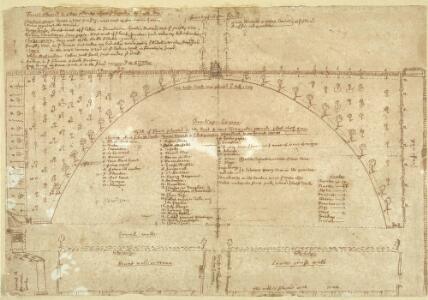
Plan of Sayes Court with lists of fruit trees B
Plan showing one of John Evelyn's garden designs at Sayes Court. At Sayes Court in Deptford, Evelyn put his theories into practice and produced one of London's greatest gardens. Though now long lost, we can rediscover the garden in minute detail thanks to a plan drawn up to Evelyn's instructions when he first began to lay out the garden in the early 1650s. It was "the guide of all our designs". The meticulous plan, provided with a key describing every feature, gives a unique and vivid evocation of the garden one contemporary called "the little world that goes under the name of Sayes Court." It was first intended to communicate his ideas for the estate to his father-in-law, but the detailed nature of the plan suggests that Evelyn also had publication in mind. This drawing shows that after the very severe winter of 1683-4, the layout of the south-west part of the Sayes Court garden was much simplified.The former parterre was converted into a semi-circle of lawn and the quadrants planted with fruit.The varieties are listed in this plan of February 1685 by Evelyn include cherries, pears, apples, plums apricots, vines, figs, gooseberries and strawberries. Low growing fruit was also planted along some of the walkways: "a very private passage out of the oval neich into the walke" was planted with "dwarfe fruit. Raspberries, Strawberries, Currants & Cherries..." Evelyn, John
Plan of Sayes Court House and Garden
This plan of the house and garden at Sayes Court shows in detail the renovations to the house and outbuildings and the new garden layout of the parterre, grove and orchard designed and carried out by John Evelyn. The property had long been held by Evelyn's wife's family as a crown lease, and he lived there from 1652 until he moved to his own ancestral home at Wotton in Surrey in 1694. The line dividing the key from the plan actually represents the dock wall. Sandwiched between the docks and the yards where cattle were slaughtered, this was not an ideal location for a tranquil garden. But at Sayes Court Evelyn, inspired by French and Italian ideas, created one of the most influential gardens of his day. Evelyn, John
London XI.20 - OS London Town Plan
1 : 1056 Topographic maps Ordnance Survey Ordnance Survey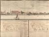
View of the Dockyard at Deptford Folios 65v 66
As the royal dockyard closest to London, Deptford was the headquarters of the administration of the navy from Tudor times onwards, and the focus of a populous community of shipyard workers. This drawing is part of a comprehensive survey of the royal dockyards made in 1698. This work is attributed to Edmund Dummer who was chief surveyor to the British Royal Navy at this time, and was intended to illustrate the exact state of the dockyards. The 2 plans below the view of Deptford from the river illustrate the changes and improvements to the dockyard between 1688 and 1698. [Dummer, Edmund]
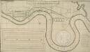
Map of Deptford, with annotations on population growth by John Evelyn
This is a map of the dockyard and town of Deptford in 1623, with additions by John Evelyn, including (near the lower edge of the map) the only known original drawing of Sayes Court house. Writing in 1703, Evelyn notes the great increase in the population of Deptford since the map was made, commenting that, "the Town is in 80 yeares become neere as big as Bristoll". At this time the 3 largest cities in the country were London, Norwich and Bristol, so this statement demonstrates how rapidly Evelyn perceived the town to have grown in his lifetime. Evelyn, John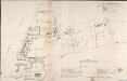
A MAP OF DEPTFORD, 1623. From an Original Pen and Ink Sketch with additional remarks by JOHN EVELYN, ESQ.R
Engraving of the map of Deptfordof 1623 with the addition madeby John Evelyn, including (near the lower edge of the map) the only known original drawing of the manor house at Sayes Court. Writing in 1703, Evelyn notes the great increase in the population of Deptford since the map was made, commenting that, "the Town is in 80 yeares become neere as big as Bristoll". At this time the 3 largest cities in the country were London, Norwich and Bristol, so this statement demonstrates how rapidly Evelyn perceived the town to have grown in his lifetime. Evelyn, John
London (1915- Numbered sheets) IX.4 (includes: Bermondsey; Borough Of Greenwich; Deptford St Paul) - 25 Inch Map
1 : 2500 Topographic maps Ordnance Survey Ordnance Survey
London (Edition of 1894-96) XCI (includes: Bermondsey; Borough Of Greenwich; Deptford St Paul) - 25 Inch Map
1 : 2500 Topographic maps Ordnance Survey Ordnance Survey
London (First Editions c1850s) LVII (includes: Bermondsey; Borough Of Greenwich; Deptford St Paul) - 25 Inch Map
1 : 2500 Topographic maps Ordnance Survey Ordnance Survey
London XI.NE - OS Six-Inch Map
1 : 10560 Topographic maps Ordnance Survey Ordnance Survey
Surrey III.SE - OS Six-Inch Map
1 : 10560 Topographic maps Ordnance Survey Ordnance Survey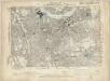
Kent I.SE - OS Six-Inch Map
1 : 10560 Topographic maps Ordnance Survey Ordnance Survey
An Actuall Survey of the Parish of St Dunstan Stepney alias Stebunheath ... Taken ... 1703 by Ioel Gascoyne, engraven by Iohn Harris. A scale of 1320 yards[ = 9 inches]
A PROPOSED PLAN FOR WET DOCKS IN WAPPING &c.
1 : 8175 Proposed plan for wet docks at Wapping, with title along the top, key at bottom right, tide table for Blackwall at bottom centre and inset plan of docking and storage facilities at bottom left. This was one of many large scale plans for new docking and shipping facilities for London submitted to Parliament after a Parliamentary Committee reported on the congestion and inadequacy of the London port in 1796. Walker, Ralph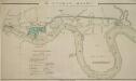
The LONDON DOCKS
1 : 14080 This is Daniel Alexanders original design for the London Docks and Cut. The plan's title and key are at lower left, with the site of the new docks highlighted in blue. Alexander's original design included a 20-acre St. Georges Dock to the west and a seven-acre Shadwell Dock to the east. Each would have their own basin, and be linked by a small Tobacco Dock. Opened in 1805, London Docks were the nearest to the city, and for 21 years all imported tobacco, rice, wine and brandy (except that from the East and West Indies) had to unload there. Alexander, Daniel
Charles Booth's descriptive map of London poverty 1889
Charles Booth
PLAN SHEWING THE PROPOSED LINE of the LONDON AND GREENWICH RAILWAY
1 : 7200 The title of this plan appears at bottom left, with an explanatory note and scale bar at bottom centre. An illustration of the general construction of the railway features at bottom right. The Greenwich line reached Bermondsey in 1836. A year later, it reached London Bridege, which became the first railway terminus in the capital. Wyld, James
Insurance Plan of London East South East District Vol. H: Key Plan
1 : 10560 This "key plan" indicates coverage of the Goad 1897 series of fire insurance maps of London that were originally produced to aid insurance companies in assessing fire risks. The building footprints, their use (commercial, residential, educational, etc.), the number of floors and the height of the building, as well as construction materials (and thus risk of burning) and special fire hazards (chemicals, kilns, ovens) were documented in order to estimate premiums. Names of individual businesses, property lines, and addresses were also often recorded. Together these maps provide a rich historical shapshot of the commercial activity and urban landscape of towns and cities at the time. The British Library holds a comprehensive collection of fire insurance plans produced by the London-based firm Charles E. Goad Ltd. dating back to 1885. These plans were made for most important towns and cities of the British Isles at the scales of 1:480 (1 inch to 40 feet), as well as many foreign towns at 1:600 (1 inch to 50 feet). Chas E Goad Limited Chas E Goad Limited
FAIRBURN'S PLAN of the proposed WET-DOCKS AND CUT from NEW GRAVEL LANE to BLACKWALL
1 : 16896 The plan's title and publisher's imprint appear at bottom left, with a compass star, key and scale bar at bottom centre.The boundary of the area to be developed is highlighted in red. After a Parliamentary Select Committee in 1796 condemned the congestion at the Port of London, a number of large-scale projects for new docking and shipping facilities were submitted to Parliament. Fairburn's plan illustrates the London merchants' scheme. It consists of an entrance dock that could accommodate 33 loaded ships, two main docks that would accommodate a total of 355 ships and a separate dock for lighters. The plan also included the creation of the 2" 3/4 mile long cut from Wapping to Blackwall. An improved version of this scheme would eventually materialise as the London Docks. Fairburn, John
Rowe's map of London, westminster and Southwark, exhibiting the various improvements to the year 1804, detail showing the London and west india Docks
A canal and the two West India docks now cut across the neck of the Isle of Dogs to provide shipping with a shortcut across its marshy peninsular. A wall around its edge holds back the tidal Thames while windmills on the windy west side pump water from the marsh. As industry spreads, wealthy residents are lured away to the fashionable new suburbs rising to the west of London. Turnpikes appear, on the Hackney Road for example: an indication of the growing need for good roads and the money to maintain them. From the tangle of older streets, the line of the proposed new Commercial Road shoots straight across the open fields. Rowe
Insurance Plan of London Vol. xi: Key Plan 2
1 : 3600 This "key plan" indicates coverage of the Goad 1891 series of fire insurance maps of London that were originally produced to aid insurance companies in assessing fire risks. The building footprints, their use (commercial, residential, educational, etc.), the number of floors and the height of the building, as well as construction materials (and thus risk of burning) and special fire hazards (chemicals, kilns, ovens) were documented in order to estimate premiums. Names of individual businesses, property lines, and addresses were also often recorded. Together these maps provide a rich historical shapshot of the commercial activity and urban landscape of towns and cities at the time. The British Library holds a comprehensive collection of fire insurance plans produced by the London-based firm Charles E. Goad Ltd. dating back to 1885. These plans were made for most important towns and cities of the British Isles at the scales of 1:480 (1 inch to 40 feet), as well as many foreign towns at 1:600 (1 inch to 50 feet). Chas E Goad Limited Chas E Goad Limited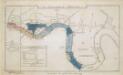
The Merchants' Plan of the London Docks, by D. Alexander, 1796; with the Stations for Ships in the River

London SE.
1 : 15840 Stanford, Edward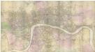
PLAN of the Cities of LONDON and WESTMINSTER the Borough of SOUTHWARK and PARTS adjoining Shewing every HOUSE. By R. Horwood.
This magnificent map covers 32 sheets, each measuring 21" 5/8 x 19" 3/4. It was published sheet by sheet between 1792 and99 and was the work of several engravers under the direction of cartographer Richard Horwood. It is generally considered to be the most important London map of the 18th century. Horwood intended originally to show every house and its number but this was to prove impossible. Although every house is included the numbering was never completed. Horwood dedicated this map to the Trustees and Directors of the Phoenix Fire Office, reflecting that the protection of London from fire was at this time the reserve of numerous independent company brigades. The map is coloured, describing parks in green and the London Wall in red. The Tower of London is shown only by outline; Horwood records that: 'The Internal Parts not distinguished being refused permission to take the Survey’, evidence that a surveyor was not always welcome. Southwark was traditionally a district where the industries of brewing and tanning, unwelcome in the main city, were located. Barclay Perkins & Cos., which in the coming century was to become the largest brewery in the world, is marked on the map, as is Guy's Hospital ("for incurables") which at had recently been extended to include a new hospital for the psychiatrically disturbed. This map was reissued at least four times, with relevant additions and alterations, up until 1819. Horwood, Richard
PLAN of the Cities of LONDON and WESTMINSTER the Borough of SOUTHWARK and PARTS adjoining Shewing every HOUSE. By R. Horwood
Map of London printed in 32 sheets and published sheet by sheet between 1792 and 1799, the work of several engravers working to the direction of the cartographer Richard Horwood. Horwood dedicated this map to the Trustees and Directors of the Phoenix Fire Office, reflecting that the protection of London from fire was at this time the reserve of numerous independent company brigades. This edition features a Phoenix at top left with the word "protection" emblazoned beneath it and is uncoloured in its entirety. The Tower of London is shown only by outline, as Horwood records that "The Internal Parts not distinguished being refused permission to take the Survey", testimony that a surveyor was not always welcome. Industries such as brewing and tanning, unwelcome in the city, are located south of the river in Southwark. Barclay Perkins & Co., the largest brewery in the world during the 1800s, is marked on the map, as is Guy's Hospital (for incurables). At the time of this map, the hospital had recently been extended to include a new ward for "lunatics". This map was re-issued, with additions and alterations, at least four times until 1819. Horwood, Richard
Insurance Plan of London East District Vol. G: Key Plan
1 : 3600 This "key plan" indicates coverage of the Goad 1900 series of fire insurance maps of London that were originally produced to aid insurance companies in assessing fire risks. The building footprints, their use (commercial, residential, educational, etc.), the number of floors and the height of the building, as well as construction materials (and thus risk of burning) and special fire hazards (chemicals, kilns, ovens) were documented in order to estimate premiums. Names of individual businesses, property lines, and addresses were also often recorded. Together these maps provide a rich historical shapshot of the commercial activity and urban landscape of towns and cities at the time. The British Library holds a comprehensive collection of fire insurance plans produced by the London-based firm Charles E. Goad Ltd. dating back to 1885. These plans were made for most important towns and cities of the British Isles at the scales of 1:480 (1 inch to 40 feet), as well as many foreign towns at 1:600 (1 inch to 50 feet). Chas E Goad Limited Chas E Goad Limited
An exact survey of the city's of London Westminster , III
1 Blatt : 53 x 71 cm John Rocque
An exact survey of the city's of London Westminster , II
1 Blatt : 53 x 71 cm John Rocque
London
Grosser Hand-Atlas über alle Theile der Erde in 170 Karten Meyer, J. Verlag des Bibliographischen Instituts