Maps of Kensington and Chelsea

Kensington Gore Sheet 7-A
Kensington Gore, depicted here opposite Hyde Park, takes its name from "gara", an old English word describing a triangular plot of land which was left when ploughing fields of irregular shape. The property at No.1 Kensington Gore marks the boundary between the parishes of Kensington and St Margaret Westminster. A well, shown along the north side of the road, and a horse trough outside the Hand and Flower public house, testify to the incredible level of detail with which Salway recorded all features of the road managed by the Turnpike Trust. Salway, Joseph
Kensington Gore Sheet 8
Kensington Gore, depicted here opposite Hyde Park, takes its name from "gara", an old English word describing a triangular plot of land which was left when ploughing fields of irregular shape. Private gardens of properties on Kensington Gore are shown in plan form, revealing the formal designs of lawns and cobblestone paths. Salway, Joseph
Knightsbridge, 1 Mile from Hyde Park Corner
Gray's Nursery and Seed Shopis depicted in plan form on the south side of this stretch of Knightsbridge, next to property belonging to James Vere. A milestone on the north side of the road indicates a distance ofone mile to Hyde Park Corner, where the toll road terminated. Salway, Joseph
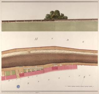
Kensington Gore Sheet 7
Among the residents of Kensington Gore was the philanthropist and parliamentarian William Wilberforce, whose name is associated with the campaign for the abolition of the slave trade. Gore House, wherehe lived between 1808 and 1821, is depicted in plan form on the south side of Kensington Gore. Built in the 1750s, the house was decorated by the architect Robert Adams. It was the most easterly of a row of mansions built in the 18th century between Palace Gate and Knightsbridge. Salway, Joseph
Knightsbridge showing the Halfway House
The Halfway House is depicted in plan and elevation on the north side of the road on the site of today's Prince of Wales Gate. This ancient inn, with its ramshackle stables and pigsties, had long been popular with highwaymen in the area. Salway, Joseph
Plan of Estates IN THE PARISHES OF KENSINGTON AND ST MARGARET'S WESTMINSTER IN THE COUNTY OF MIDDLESEX Purchased by HER MAJESTY'S COMMISSIONERS for the EXHIBITION OF 1851.
1 : 4800 The site in South Kensington depicted in green on this plan was purchased by the Queen's Commissioners to host the Great Exhibition of 1851. The title, key to colours, compass star and scale bar appear down the left side of the plate. The boundaries of the four properties comprising the commissioners' estate are outlined as follows: Gore House in blue, Villar in red, Harrington in yellow and the Smith's Charity Estate in brown. Day & Son
Plan Generale du Palais & Jardins de Kensington Situe dans la Conte de Middlesex a 2 miles de Londres tres Exactement Leve dessiene & Grave par Jean Rocque 1736
1 : 2400 On this plan of Kensington Palace and gardens, the key is at bottom left, with title and dedication at bottom centre, and scale bar at bottom left. The Kensington Gardens were originally attached to Nottingham House, which was bought in 1689 by William III and turned into Kensington Palace. Queen Mary took a great interest in the gardens and had them landscaped by royal gardeners in formal Dutch patterns. Uprooted by order of Queen Anne at the beginning of the 18th century, the Dutch gardens were replaced in 1726 by this Wise and Bridgeman design, which included the round pond, the Broad Walk and the Temple Lodge. Rocque, John
MILITARY SKETCH OF HYDE PARK
This plan shows the barracks along Knightsbridge erected for the Horse Guard at the end of the 18th century. The title appears at lower left, below the scale bar. At over 340 acres the largest of the royal parks, Hyde Park was originally a hunting ground for deer, boars and wild bull. Bequeathed to the monks of Westminster after the conquest of Geoffrey de Mandeville in the 1140s, the park was appropriated by Henry VIII at the dissolution of the monasteries in 1536. The park was opened to e public at the beginning of the 17th century and remained a deer-hunting ground until 1768. Baker, B.
London (1915- Numbered sheets) IV.16 (includes: City Of Westminster; Kensington; Paddington) - 25 Inch Map
1 : 2500 Topographic maps Ordnance Survey Ordnance Survey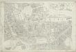
London (First Editions c1850s) XLII (includes: City Of Westminster; Kensington; Paddington) - 25 Inch Map
1 : 2500 Topographic maps Ordnance Survey Ordnance Survey
PLAN OF HYDE PARK as it was in 1725
1 : 792 This retrospective plan of Hyde Park was produced from an earlier plan held in the Vestry Room in St George's Church, Hanover Square. Its title features at top right, with the scale bar at top left. At over 340 acres of land the largest of all the royal parks, Hyde Park was originally a hunting ground for deer, boars and wild bull. Bequeathed to the monks of Westminster after the conquest of Geoffrey de Mandeville in the 1140s, the park was appropriated by Henry VIII at the dissolution of the monasteries in 1536. The park was opened to the public at the beginning of the 17th century, and remained a deer hunting ground until 1768. Neele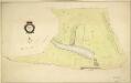
HYDE PARK
1 : 3960 The title and compass star of this plan appear at middle left, with them scale bar at bottom right. At over 340 acres the largest of all the royal parks, Hyde Park was originally a hunting ground for deer, boars and wild bull. Bequeathed to the monks of Westminster after the conquest of Geoffrey de Mandeville in the 1140s, the park was appropriated by Henry VIII at the dissolution of the monasteries in 1536. The park was opened to the public at the beginning of the 17th century, and remained a deer hunting ground until 1768. Bennett, S.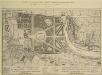
A Plan of the Palace Gardens and TOWN of KENSINGTON
1 : 4800 The title of this plan of Kensington Palace and gardens appears in English and French, with scale bars and a key to architectural and natural features, in a panel below the plan. Kensington Gardens were originally attached to Nottingham House, which was bought in 1689 by William III and turned into Kensington Palace. Queen Mary took a great interest in the gardens and had them landscaped by royal gardeners in formal Dutch patterns. Uprooted by order of Queen Anne at the beginning of the 18th century, the Dutch gardens were replaced in 1726 by this Wise and Bridgeman design, including the round pond, the Broad Walk and the Temple Lodge. Rocque, John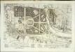
A plan of the palace gardens and town of Kensington
1 Plan : Kupferdruck ; 28 x 48 cm Rocque; Deharme John Rocque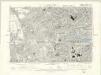
London VI.SE - OS Six-Inch Map
1 : 10560 Topographic maps Ordnance Survey Ordnance Survey
Plan of the parish of PADDINGTON in the County of Middlesex 6
The development of Paddington began at the end of the Napoleonic wars, when the Bishop of London granted permission for building on his estate north of Hyde Park. Under Gutch's supervision, works continued into the 1850s, extending to Bayswater and the Edgware and Harrow Roads. The title of this plan appears at top left, with compass rose at top right and scale bar at bottom left. Also at bottom left is a key to the land acquired by the Grand Junction Canal Company from the Bishop of London. This the area in red on the plan, which also shows the final proposals for the new street plan at Bayswater. Gutch, George
Plan of the parish of PADDINGTON in the County of Middlesex 7
The development of Paddington began at the end of the Napoleonic wars, when the Bishop of London granted permission for building on his estate north of Hyde Park. Under Gutch's supervision, works continued into the 1850s, extending to Bayswater and the Edgware and Harrow Roads. The title of this plan appears at top left, with compass rose at top right and scale bar at bottom left. It shows the final street plan, with the Bishop of London's estate outlined in green, the Great Western Railway terminus in red, and the Paddington estate in yellow. Gutch, George
A PLAN of HYDE-PARK with the CITY and LIBERTIES of WESTMINSTER &c. Shewing the several IMPROVEMENTS propos'd
This plan shows renovations in Hyde Park and around Westminster.Two Royal palaces have been planned, in Hyde Park and Green Park. The red lines show an intention to regularize the street plan, replacing the narrow irregular streets with a gridlike formation. Gwynn, John
Charles Booth's descriptive map of London poverty 1889
Charles Booth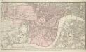
PLAN OF WESTMINSTER. No III
The area shaded red represents the extent of Westminster as defined in the Letters Patent of 3 August 1604. Basire, J.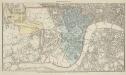
PLAN OF WESTMINSTER. No II
This map is highlighted to give a retrospective view of the extent of Westminster. Represented in blue is the territory of Westminster according to the Decretal of AD1222 , while the red outline shows the present boundary. The green and yellow outlines indicate manor boundaries. Basire, J.
PLAN OF WESTMINSTER. No 1 [A Plan of the City of Westminster, showing all the Parishes, as well as the Ancient Boundary of Westminster, in the year 951.]
An orange coloured area shows the extent of Westminster according to King Edgar's Charter of AD951. The contemporary boundary of Westminster is shown in red. Basire, J.
London NW.
1 : 15840 Stanford, Edward
London SW.
1 : 15840 Stanford, Edward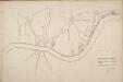
Thames and Metropolis Improvement plan
Martin, John
A PLAN of the ROADS Under the DIRECTION and CARE of this TRUST and divers Roads Adjacent.
1 : 16351 The title of this road map of Kensington and Chelsea appears in a panel above the plan, with the compass star at top right and scale bar at bottom left. The roads within the Kensington and Hyde Park Trust are indicated by a shadowed line; the king's private roads by a double line; the common roads by a double dotted line; and the footpaths by a single dotted line. Turnpikes and junctions are numbered for reference with distances given in a table down the left side of the plate. Roberts, R.
MAP OF THE WESTERN SIDE OF LONDON, DISTINGUISHING THE ESTATE OF HER MAJESTY'S COMMISSIONERS FOR THE EXHIBITION OF 1851.
1 : 21120 Map of Kensington with title along the top and scale bar below the plan. The site of the Great Exhibiton of 1851 in Hyde Park is highlighted in green. Day & Son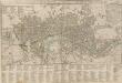
CARY's New POCKET PLAN OF LONDON, WESTMINSTER and SOUTHWARK; with all the adjacent buildings in ST. GEORGE'S FIELDS &c.&c.
Pocket plans were made popular by the Bowles companying the 1730s, and had an enduring appeal. This plan, engraved by the prolific John Cary, was published 18 times. This is the first edition. It includes a list of the receiving houses appointed by the General and Penny Post Offices and a table of Hackney coach fares. The postal service in London was largely developed by William Dockwra, who responded to the demand for local letter delivery in London: non-existent until 1680, except by private messenger. Dockwra opened nearly 500 receiving houses where letters were sorted for delivering, costing the user one penny. So successful was this system that it was taken over by the General Post Office after two years. Cary, John
Insurance Plan of London West & West North West Vols. A & B: Key Plan
1 : 10560 This "key plan" indicates coverage of the Goad 1891 series of fire insurance maps of London that were originally produced to aid insurance companies in assessing fire risks. The building footprints, their use (commercial, residential, educational, etc.), the number of floors and the height of the building, as well as construction materials (and thus risk of burning) and special fire hazards (chemicals, kilns, ovens) were documented in order to estimate premiums. Names of individual businesses, property lines, and addresses were also often recorded. Together these maps provide a rich historical shapshot of the commercial activity and urban landscape of towns and cities at the time. The British Library holds a comprehensive collection of fire insurance plans produced by the London-based firm Charles E. Goad Ltd. dating back to 1885. These plans were made for most important towns and cities of the British Isles at the scales of 1:480 (1 inch to 40 feet), as well as many foreign towns at 1:600 (1 inch to 50 feet). Chas E Goad Limited Chas E Goad Limited