Maps of Kensington and Chelsea

Knightsbridge showing the Horse Barracks
The Horse Guard Barracks, depicted on the north side of Knightsbridge, were built shortly after the French Revolution at the end of the 18th century when the authorities feared insurrections at home. By the 1870s the barracks, considered too cramped and dilapidated, were pulled down and replaced by new buildings designed by Wyatt in 1880. The estate shown on Trevor Terrace, on the south side of the road, takes its name from Sir John Trevor, the Master of the Rolls and Speaker of the House of Commons, who built a house on this site in circa 1700. The estate illustrated here was built by his cousin, Arthur Trevor Hill, in the early 19th century. Salway, Joseph
Knightsbridge showing the Horse Barracks Sheet 3-A
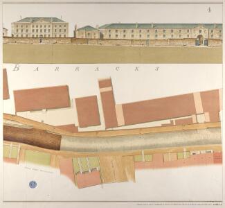
The Horse Guard Barracks are depicted on the north side of Knightsbridge. Built at the end of the 18th century, shortly after the French Revolution, when the authorities feared insurrections at home, the barracks provided accommodation for 600 men and 500 horses. By the 1870s the barracks, considered too cramped and dilapidated, were pulled down and replaced by new buildings designed by Wyatt in 1880. In 1959 these were further replaced by Basil Spence's 270 feet high tower block. A milestone outside the barracks indicates half mile distance to Hyde Park Corner. Salway, Joseph
Knightsbridge showing the Horse Barracks Sheet 4-A
The Horse Guard Barracks, depicted hereon the north side of Knightsbridge, were built shortly after the French Revolution, at the end of the 18th century, when the authorities feared insurrections at home. The barracks housed 600 men in the Household Cavalry and 500 horses. By the 1870s the barracks, considered too cramped and dilapidated, were pulled down and replaced by new buildings designed by Wyatt in 1880. In1959 these were further replaced by Basil Spence's 270 feet high tower block. Salway, Joseph
Knightsbridge showing the Halfway House
The Halfway House is depicted in plan and elevation on the north side of the road on the site of today's Prince of Wales Gate. This ancient inn, with its ramshackle stables and pigsties, had long been popular with highwaymen in the area. Salway, Joseph
London VI.90 - OS London Town Plan
1 : 1056 Topographic maps Ordnance Survey Ordnance Survey
MILITARY SKETCH OF HYDE PARK
This plan shows the barracks along Knightsbridge erected for the Horse Guard at the end of the 18th century. The title appears at lower left, below the scale bar. At over 340 acres the largest of the royal parks, Hyde Park was originally a hunting ground for deer, boars and wild bull. Bequeathed to the monks of Westminster after the conquest of Geoffrey de Mandeville in the 1140s, the park was appropriated by Henry VIII at the dissolution of the monasteries in 1536. The park was opened to e public at the beginning of the 17th century and remained a deer-hunting ground until 1768. Baker, B.
London (1915- Numbered sheets) IV.16 (includes: City Of Westminster; Kensington; Paddington) - 25 Inch Map
1 : 2500 Topographic maps Ordnance Survey Ordnance Survey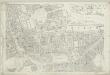
London (First Editions c1850s) XLII (includes: City Of Westminster; Kensington; Paddington) - 25 Inch Map
1 : 2500 Topographic maps Ordnance Survey Ordnance Survey
PLAN OF HYDE PARK as it was in 1725
1 : 792 This retrospective plan of Hyde Park was produced from an earlier plan held in the Vestry Room in St George's Church, Hanover Square. Its title features at top right, with the scale bar at top left. At over 340 acres of land the largest of all the royal parks, Hyde Park was originally a hunting ground for deer, boars and wild bull. Bequeathed to the monks of Westminster after the conquest of Geoffrey de Mandeville in the 1140s, the park was appropriated by Henry VIII at the dissolution of the monasteries in 1536. The park was opened to the public at the beginning of the 17th century, and remained a deer hunting ground until 1768. Neele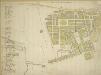
Plan of the Parish of St. George, Hanover Square
The streets of the parish are numbered in red ink for reference, with a key along the left side of the sheet.The Parish of St George was created in 1725 and covered an area previously in the Parish of St. Martin-in-the-Fields that stretched from Regent Street (then called Swallow Street) to the Serpentine, and from Oxford Street to Mayfair, Belgravia and Pimlico.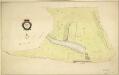
HYDE PARK
1 : 3960 The title and compass star of this plan appear at middle left, with them scale bar at bottom right. At over 340 acres the largest of all the royal parks, Hyde Park was originally a hunting ground for deer, boars and wild bull. Bequeathed to the monks of Westminster after the conquest of Geoffrey de Mandeville in the 1140s, the park was appropriated by Henry VIII at the dissolution of the monasteries in 1536. The park was opened to the public at the beginning of the 17th century, and remained a deer hunting ground until 1768. Bennett, S.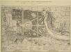
A Plan of the Palace Gardens and TOWN of KENSINGTON
1 : 4800 The title of this plan of Kensington Palace and gardens appears in English and French, with scale bars and a key to architectural and natural features, in a panel below the plan. Kensington Gardens were originally attached to Nottingham House, which was bought in 1689 by William III and turned into Kensington Palace. Queen Mary took a great interest in the gardens and had them landscaped by royal gardeners in formal Dutch patterns. Uprooted by order of Queen Anne at the beginning of the 18th century, the Dutch gardens were replaced in 1726 by this Wise and Bridgeman design, including the round pond, the Broad Walk and the Temple Lodge. Rocque, John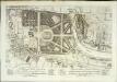
A plan of the palace gardens and town of Kensington
1 Plan : Kupferdruck ; 28 x 48 cm Rocque; Deharme John Rocque
Drawn plan of the Goring Estate] 3
This is a copy by Crace of a plam of the Goring Estate as it was in 1640. The drawing shows the site in Mulberry Garden Fields where Buckingham Palace was built. Crace, Frederick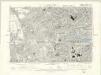
London VI.SE - OS Six-Inch Map
1 : 10560 Topographic maps Ordnance Survey Ordnance Survey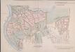
MAP of the GROSVENOR ESTATE (tinted pink) as it was in the Year 1723. with the intended Streets about Grosvenor Square.
1 : 5592 The title of this plan features at top right, with compass star at middle right and explanatory note at bottom right. The boundaries of the St George parish are outlined in red, with the properties in the estate in pink, and parks and open spaces in green. The plan shows the proposed new street plans for Grosvenor Square, but not the Chelsea waterworks,which featured in the original drawing from which this print was produced.
Plan of the parish of PADDINGTON in the County of Middlesex 6
The development of Paddington began at the end of the Napoleonic wars, when the Bishop of London granted permission for building on his estate north of Hyde Park. Under Gutch's supervision, works continued into the 1850s, extending to Bayswater and the Edgware and Harrow Roads. The title of this plan appears at top left, with compass rose at top right and scale bar at bottom left. Also at bottom left is a key to the land acquired by the Grand Junction Canal Company from the Bishop of London. This the area in red on the plan, which also shows the final proposals for the new street plan at Bayswater. Gutch, George
Plan of the parish of PADDINGTON in the County of Middlesex 7
The development of Paddington began at the end of the Napoleonic wars, when the Bishop of London granted permission for building on his estate north of Hyde Park. Under Gutch's supervision, works continued into the 1850s, extending to Bayswater and the Edgware and Harrow Roads. The title of this plan appears at top left, with compass rose at top right and scale bar at bottom left. It shows the final street plan, with the Bishop of London's estate outlined in green, the Great Western Railway terminus in red, and the Paddington estate in yellow. Gutch, George
A PLAN of HYDE-PARK with the CITY and LIBERTIES of WESTMINSTER &c. Shewing the several IMPROVEMENTS propos'd
This plan shows renovations in Hyde Park and around Westminster.Two Royal palaces have been planned, in Hyde Park and Green Park. The red lines show an intention to regularize the street plan, replacing the narrow irregular streets with a gridlike formation. Gwynn, John
Charles Booth's descriptive map of London poverty 1889
Charles Booth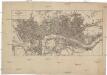
Plan von London und Westminster mit der Borough von Southwark
Londýn (Anglie)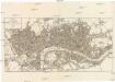
PLAN von LONDON und WESTMINSTER mit der BOROUGH von SOUTHWARK
Londýn (Anglie)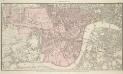
PLAN OF WESTMINSTER. No III
The area shaded red represents the extent of Westminster as defined in the Letters Patent of 3 August 1604. Basire, J.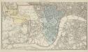
PLAN OF WESTMINSTER. No II
This map is highlighted to give a retrospective view of the extent of Westminster. Represented in blue is the territory of Westminster according to the Decretal of AD1222 , while the red outline shows the present boundary. The green and yellow outlines indicate manor boundaries. Basire, J.
PLAN OF WESTMINSTER. No 1 [A Plan of the City of Westminster, showing all the Parishes, as well as the Ancient Boundary of Westminster, in the year 951.]
An orange coloured area shows the extent of Westminster according to King Edgar's Charter of AD951. The contemporary boundary of Westminster is shown in red. Basire, J.
Insurance Plan of London South West District Vol. K: Key Plan
1 : 10560 This "key plan" indicates coverage of the Goad 1897 series of fire insurance maps of London that were originally produced to aid insurance companies in assessing fire risks. The building footprints, their use (commercial, residential, educational, etc.), the number of floors and the height of the building, as well as construction materials (and thus risk of burning) and special fire hazards (chemicals, kilns, ovens) were documented in order to estimate premiums. Names of individual businesses, property lines, and addresses were also often recorded. Together these maps provide a rich historical shapshot of the commercial activity and urban landscape of towns and cities at the time. The British Library holds a comprehensive collection of fire insurance plans produced by the London-based firm Charles E. Goad Ltd. dating back to 1885. These plans were made for most important towns and cities of the British Isles at the scales of 1:480 (1 inch to 40 feet), as well as many foreign towns at 1:600 (1 inch to 50 feet). Chas E Goad Limited Chas E Goad Limited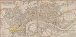
A New and Complete Plan of LONDON, WESTMINSTER & BOROUGH OF SOUTHWARK containing the Improvements IN, and ROUND the METROPOLIS
Roads and open spaces are depicted in different colours and margins divided into miles and furlongs. The map’s title and a list of districts in Westminster are at the top left, with a key to public offices and Westminster parishes at the bottom left. The fares of hackney coaches and water ferries are at the bottom right, along with a list of Surrey parishes. At middle right, there is a list of parishes within the 'Bill of Mortality' - the name given to parishes who sent regular death notices to the central London government. A fine mezzotint engraver and regular exhibitor at the Society of Artists in the 1770s, Robert Laurie acquired Sayer’s stock in 1794 and (with James Whittle) founded the map publishing house Laurie & Whittle. Laurie, Robert and Whittle, James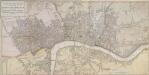
A NEW POCKET PLAN OF THE CITIES OF LONDON & WESTMINSTER WITH THE BOROUGH OF SOUTHWARK: Comprehending the New Buildings and other Alterations to the Year 1790
This is the third edition of William Faden's 1787 map, which was printed 11 times over a period of 25 years. Faden called himself "Geographer to the King”, and was very interested the work of the Ordnance Survey. In 1800 he published 'An account of the operations carried on for accomplishing a trigonometrical survey of England and Wales'. Faden's skill as a cartographer was so well-noted that his map of 'The Country Twenty-Five Miles round London' was re-engraved for the French War Department in preparation for an invasion of England. This map includes a list of Surrey Parishes within the Bills of Mortality, an area of 109 parishes in and near London from which a weekly report of deaths was collated. Westminster is divided into 12 districts, each indicated by coloured boundaries. William Faden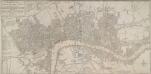
BOWLES'S NEW POCKET PLAN OF THE CITIES OF LONDON & WESTMINSTER; WITH THE BOROUGH OF SOUTHWARK: Comprehending the New Buildings and other Alterations to the Year 1780
This map was printed for Caringtom Bowles who traded from a St. Paul's churchyard. The Bowles family were not cartographers but published and sold maps. This is the fourth edition of a map originally issued in 1773.The title is at top left, next to a list of parishes, with a key to Great Offices of State and Westminster parishes down the left of the plate. The border of the map is marked off in miles and furlongs. There is no discernible difference between this edition and the previous ones. Bowles, Carington