Maps of Lewisham

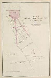
Plan of the Proposed Pier at Deptford in the County of Kent
Plan of the proposed pier at Deptford showing the ground plot of the pier and the changes to the street lay out to allow access to the pier highlighted in red. After the closure ofDeptford's Royal Dockyard in the early 19th century, vast tracts of landwere left unemployed on the water front and in the environs of the old Church of St Nicholas. In 1839, an Act of Parliament was passed, establishing the Deptford Pier and Improvement Company. As laid out in the Act, the company's purpose was to "build a new town, consisting of wide streets, adapted for healthful residence or commercial occupation". Landmann, George Ledger, Horson
Map of Deptford, with annotations on population growth by John Evelyn
This is a map of the dockyard and town of Deptford in 1623, with additions by John Evelyn, including (near the lower edge of the map) the only known original drawing of Sayes Court house. Writing in 1703, Evelyn notes the great increase in the population of Deptford since the map was made, commenting that, "the Town is in 80 yeares become neere as big as Bristoll". At this time the 3 largest cities in the country were London, Norwich and Bristol, so this statement demonstrates how rapidly Evelyn perceived the town to have grown in his lifetime. Evelyn, John
A MAP OF DEPTFORD, 1623. From an Original Pen and Ink Sketch with additional remarks by JOHN EVELYN, ESQ.R
Engraving of the map of Deptfordof 1623 with the addition madeby John Evelyn, including (near the lower edge of the map) the only known original drawing of the manor house at Sayes Court. Writing in 1703, Evelyn notes the great increase in the population of Deptford since the map was made, commenting that, "the Town is in 80 yeares become neere as big as Bristoll". At this time the 3 largest cities in the country were London, Norwich and Bristol, so this statement demonstrates how rapidly Evelyn perceived the town to have grown in his lifetime. Evelyn, John
London XI.30 - OS London Town Plan
1 : 1056 Topographic maps Ordnance Survey Ordnance Survey
London XI.20 - OS London Town Plan
1 : 1056 Topographic maps Ordnance Survey Ordnance Survey
Insurance Plan of London East South East District Vol. H: sheet 5
1 : 480 This detailed 1897 plan of London is one of a series of thirteen sheets in an atlas originally produced to aid insurance companies in assessing fire risks. The building footprints, their use (commercial, residential, educational, etc.), the number of floors and the height of the building, as well as construction materials (and thus risk of burning) and special fire hazards (chemicals, kilns, ovens) were documented in order to estimate premiums. Names of individual businesses, property lines, and addresses were also often recorded. Together these maps provide a rich historical shapshot of the commercial activity and urban landscape of towns and cities at the time. The British Library holds a comprehensive collection of fire insurance plans produced by the London-based firm Charles E. Goad Ltd. dating back to 1885. These plans were made for most important towns and cities of the British Isles at the scales of 1:480 (1 inch to 40 feet), as well as many foreign towns at 1:600 (1 inch to 50 feet). Chas E Goad Limited Chas E Goad Limited
Insurance Plan of London East South East District Vol. H: sheet 7
1 : 480 This detailed 1897 plan of London is one of a series of thirteen sheets in an atlas originally produced to aid insurance companies in assessing fire risks. The building footprints, their use (commercial, residential, educational, etc.), the number of floors and the height of the building, as well as construction materials (and thus risk of burning) and special fire hazards (chemicals, kilns, ovens) were documented in order to estimate premiums. Names of individual businesses, property lines, and addresses were also often recorded. Together these maps provide a rich historical shapshot of the commercial activity and urban landscape of towns and cities at the time. The British Library holds a comprehensive collection of fire insurance plans produced by the London-based firm Charles E. Goad Ltd. dating back to 1885. These plans were made for most important towns and cities of the British Isles at the scales of 1:480 (1 inch to 40 feet), as well as many foreign towns at 1:600 (1 inch to 50 feet). Chas E Goad Limited Chas E Goad Limited
Insurance Plan of London East South East District Vol. H: sheet 11
1 : 480 This detailed 1897 plan of London is one of a series of thirteen sheets in an atlas originally produced to aid insurance companies in assessing fire risks. The building footprints, their use (commercial, residential, educational, etc.), the number of floors and the height of the building, as well as construction materials (and thus risk of burning) and special fire hazards (chemicals, kilns, ovens) were documented in order to estimate premiums. Names of individual businesses, property lines, and addresses were also often recorded. Together these maps provide a rich historical shapshot of the commercial activity and urban landscape of towns and cities at the time. The British Library holds a comprehensive collection of fire insurance plans produced by the London-based firm Charles E. Goad Ltd. dating back to 1885. These plans were made for most important towns and cities of the British Isles at the scales of 1:480 (1 inch to 40 feet), as well as many foreign towns at 1:600 (1 inch to 50 feet). Chas E Goad Limited Chas E Goad Limited
Plan of Sayes Court House and Garden
This plan of the house and garden at Sayes Court shows in detail the renovations to the house and outbuildings and the new garden layout of the parterre, grove and orchard designed and carried out by John Evelyn. The property had long been held by Evelyn's wife's family as a crown lease, and he lived there from 1652 until he moved to his own ancestral home at Wotton in Surrey in 1694. The line dividing the key from the plan actually represents the dock wall. Sandwiched between the docks and the yards where cattle were slaughtered, this was not an ideal location for a tranquil garden. But at Sayes Court Evelyn, inspired by French and Italian ideas, created one of the most influential gardens of his day. Evelyn, John
Insurance Plan of London East South East District Vol. H: sheet 12
1 : 480 This detailed 1897 plan of London is one of a series of thirteen sheets in an atlas originally produced to aid insurance companies in assessing fire risks. The building footprints, their use (commercial, residential, educational, etc.), the number of floors and the height of the building, as well as construction materials (and thus risk of burning) and special fire hazards (chemicals, kilns, ovens) were documented in order to estimate premiums. Names of individual businesses, property lines, and addresses were also often recorded. Together these maps provide a rich historical shapshot of the commercial activity and urban landscape of towns and cities at the time. The British Library holds a comprehensive collection of fire insurance plans produced by the London-based firm Charles E. Goad Ltd. dating back to 1885. These plans were made for most important towns and cities of the British Isles at the scales of 1:480 (1 inch to 40 feet), as well as many foreign towns at 1:600 (1 inch to 50 feet). Chas E Goad Limited Chas E Goad Limited
Insurance Plan of London East South-East District Vol. H: sheet 27
1 : 480 This detailed 1903 plan of London is one of a series of ten sheets in an atlas originally produced to aid insurance companies in assessing fire risks. The building footprints, their use (commercial, residential, educational, etc.), the number of floors and the height of the building, as well as construction materials (and thus risk of burning) and special fire hazards (chemicals, kilns, ovens) were documented in order to estimate premiums. Names of individual businesses, property lines, and addresses were also often recorded. Together these maps provide a rich historical shapshot of the commercial activity and urban landscape of towns and cities at the time. The British Library holds a comprehensive collection of fire insurance plans produced by the London-based firm Charles E. Goad Ltd. dating back to 1885. These plans were made for most important towns and cities of the British Isles at the scales of 1:480 (1 inch to 40 feet), as well as many foreign towns at 1:600 (1 inch to 50 feet). Chas E Goad Limited Chas E Goad Limited
Plan of Sayes Court with lists of fruit trees B
Plan showing one of John Evelyn's garden designs at Sayes Court. At Sayes Court in Deptford, Evelyn put his theories into practice and produced one of London's greatest gardens. Though now long lost, we can rediscover the garden in minute detail thanks to a plan drawn up to Evelyn's instructions when he first began to lay out the garden in the early 1650s. It was "the guide of all our designs". The meticulous plan, provided with a key describing every feature, gives a unique and vivid evocation of the garden one contemporary called "the little world that goes under the name of Sayes Court." It was first intended to communicate his ideas for the estate to his father-in-law, but the detailed nature of the plan suggests that Evelyn also had publication in mind. This drawing shows that after the very severe winter of 1683-4, the layout of the south-west part of the Sayes Court garden was much simplified.The former parterre was converted into a semi-circle of lawn and the quadrants planted with fruit.The varieties are listed in this plan of February 1685 by Evelyn include cherries, pears, apples, plums apricots, vines, figs, gooseberries and strawberries. Low growing fruit was also planted along some of the walkways: "a very private passage out of the oval neich into the walke" was planted with "dwarfe fruit. Raspberries, Strawberries, Currants & Cherries..." Evelyn, John
Insurance Plan of London East South East District Vol. H: sheet 10
1 : 480 This detailed 1897 plan of London is one of a series of thirteen sheets in an atlas originally produced to aid insurance companies in assessing fire risks. The building footprints, their use (commercial, residential, educational, etc.), the number of floors and the height of the building, as well as construction materials (and thus risk of burning) and special fire hazards (chemicals, kilns, ovens) were documented in order to estimate premiums. Names of individual businesses, property lines, and addresses were also often recorded. Together these maps provide a rich historical shapshot of the commercial activity and urban landscape of towns and cities at the time. The British Library holds a comprehensive collection of fire insurance plans produced by the London-based firm Charles E. Goad Ltd. dating back to 1885. These plans were made for most important towns and cities of the British Isles at the scales of 1:480 (1 inch to 40 feet), as well as many foreign towns at 1:600 (1 inch to 50 feet). Chas E Goad Limited Chas E Goad Limited
View of the Dockyard at Deptford Folios 65v 66
As the royal dockyard closest to London, Deptford was the headquarters of the administration of the navy from Tudor times onwards, and the focus of a populous community of shipyard workers. This drawing is part of a comprehensive survey of the royal dockyards made in 1698. This work is attributed to Edmund Dummer who was chief surveyor to the British Royal Navy at this time, and was intended to illustrate the exact state of the dockyards. The 2 plans below the view of Deptford from the river illustrate the changes and improvements to the dockyard between 1688 and 1698. [Dummer, Edmund]
London XII.21 - OS London Town Plan
1 : 1056 Topographic maps Ordnance Survey Ordnance Survey
London XII.11 - OS London Town Plan
1 : 1056 Topographic maps Ordnance Survey Ordnance Survey
Insurance Plan of London East South-East District Vol. H: sheet 25
1 : 480 This detailed 1903 plan of London is one of a series of ten sheets in an atlas originally produced to aid insurance companies in assessing fire risks. The building footprints, their use (commercial, residential, educational, etc.), the number of floors and the height of the building, as well as construction materials (and thus risk of burning) and special fire hazards (chemicals, kilns, ovens) were documented in order to estimate premiums. Names of individual businesses, property lines, and addresses were also often recorded. Together these maps provide a rich historical shapshot of the commercial activity and urban landscape of towns and cities at the time. The British Library holds a comprehensive collection of fire insurance plans produced by the London-based firm Charles E. Goad Ltd. dating back to 1885. These plans were made for most important towns and cities of the British Isles at the scales of 1:480 (1 inch to 40 feet), as well as many foreign towns at 1:600 (1 inch to 50 feet). Chas E Goad Limited Chas E Goad Limited
Insurance Plan of London East South East District Vol. H: sheet 13-1
1 : 480 This detailed 1897 plan of London is one of a series of thirteen sheets in an atlas originally produced to aid insurance companies in assessing fire risks. The building footprints, their use (commercial, residential, educational, etc.), the number of floors and the height of the building, as well as construction materials (and thus risk of burning) and special fire hazards (chemicals, kilns, ovens) were documented in order to estimate premiums. Names of individual businesses, property lines, and addresses were also often recorded. Together these maps provide a rich historical shapshot of the commercial activity and urban landscape of towns and cities at the time. The British Library holds a comprehensive collection of fire insurance plans produced by the London-based firm Charles E. Goad Ltd. dating back to 1885. These plans were made for most important towns and cities of the British Isles at the scales of 1:480 (1 inch to 40 feet), as well as many foreign towns at 1:600 (1 inch to 50 feet). Chas E Goad Limited Chas E Goad Limited
The New Foreign Cattle Market, the Central Shed, Deptford
Deptford became an important suburb of London in the 16th century, when it was one of England's main shipbuilding sites. The Royal Dockyard and The East India Company's yard were established here during the reign of Henry VIII. Despite the town's reputation as a major industrial centre in the 18th and 19th centuries, the large majority of its resident families were poor. Most of the men were unskilled labourers doing seasonal work at the dockyards. Many unsavoury "fragrances" lurked in the air, as the locality was home to glue works, gasworks, tar distilleries, breweries and manufacturers of artificial manure! News, I
Surrey III.SE - OS Six-Inch Map
1 : 10560 Topographic maps Ordnance Survey Ordnance Survey
Kent I.SE - OS Six-Inch Map
1 : 10560 Topographic maps Ordnance Survey Ordnance Survey
London (1915- Numbered sheets) IX.4 (includes: Bermondsey; Borough Of Greenwich; Deptford St Paul) - 25 Inch Map
1 : 2500 Topographic maps Ordnance Survey Ordnance Survey
London (Edition of 1894-96) XCI (includes: Bermondsey; Borough Of Greenwich; Deptford St Paul) - 25 Inch Map
1 : 2500 Topographic maps Ordnance Survey Ordnance Survey
London (First Editions c1850s) LVII (includes: Bermondsey; Borough Of Greenwich; Deptford St Paul) - 25 Inch Map
1 : 2500 Topographic maps Ordnance Survey Ordnance Survey
London (1915- Numbered sheets) X.1 (includes: Borough Of Greenwich; Poplar Borough) - 25 Inch Map
1 : 2500 Topographic maps Ordnance Survey Ordnance Survey
London (Edition of 1894-96) XCII (includes: Borough Of Greenwich; Poplar Borough) - 25 Inch Map
1 : 2500 Topographic maps Ordnance Survey Ordnance Survey
London (First Editions c1850s) LVIII (includes: Borough Of Greenwich; Poplar Borough) - 25 Inch Map
1 : 2500 Topographic maps Ordnance Survey Ordnance Survey
Insurance Plan of London East District Vol. G: sheet D
1 : 3600 This detailed 1900 plan of London is one of a series of thirty-five sheets in an atlas originally produced to aid insurance companies in assessing fire risks. The building footprints, their use (commercial, residential, educational, etc.), the number of floors and the height of the building, as well as construction materials (and thus risk of burning) and special fire hazards (chemicals, kilns, ovens) were documented in order to estimate premiums. Names of individual businesses, property lines, and addresses were also often recorded. Together these maps provide a rich historical shapshot of the commercial activity and urban landscape of towns and cities at the time. The British Library holds a comprehensive collection of fire insurance plans produced by the London-based firm Charles E. Goad Ltd. dating back to 1885. These plans were made for most important towns and cities of the British Isles at the scales of 1:480 (1 inch to 40 feet), as well as many foreign towns at 1:600 (1 inch to 50 feet). Chas E Goad Limited Chas E Goad Limited
A Plan of the East Country Dock
1 : 1200 Plan of the proposed East Country Dock adjoining the Royal Dockyard at Deptford showing the perimeter of the area to be developed highlighted in blue. Mathews, David