Maps of Islington

Plan of the British Museum as built by Sir Smirke, Robert. Ground Floor] 20-
1 : 636 This plan shows the ground floor of the British Museum built by Robert Smirke. The plan shows the galleries lay out and their usage: Miscellaneous Antiquities, Egyptian Antiquities, Phigalian Marbles. Three of the four wings of the ground floor are taken up by books in the British Museum Library which later became the British Library. Basire, James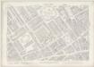
London VII.53 - OS London Town Plan
1 : 1056 Topographic maps Ordnance Survey Ordnance Survey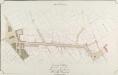
General Plan, shewing the whole line of the Proposed New Street to the British Museum
1 : 4800 A plan of the proposed street running to the British Museum in Bloomsbury. Ingrey & Madeley's
Insurance Plan of London Vol. VIII: sheet 200
1 : 480 This detailed 1888 plan of London is one of a series of twenty-six sheets in an atlas originally produced to aid insurance companies in assessing fire risks. The building footprints, their use (commercial, residential, educational, etc.), the number of floors and the height of the building, as well as construction materials (and thus risk of burning) and special fire hazards (chemicals, kilns, ovens) were documented in order to estimate premiums. Names of individual businesses, property lines, and addresses were also often recorded. Together these maps provide a rich historical shapshot of the commercial activity and urban landscape of towns and cities at the time. The British Library holds a comprehensive collection of fire insurance plans produced by the London-based firm Charles E. Goad Ltd. dating back to 1885. These plans were made for most important towns and cities of the British Isles at the scales of 1:480 (1 inch to 40 feet), as well as many foreign towns at 1:600 (1 inch to 50 feet). Chas E Goad Limited Chas E Goad Limited
Insurance Plan of London Vol. VIII: sheet 198
1 : 480 This detailed 1888 plan of London is one of a series of twenty-six sheets in an atlas originally produced to aid insurance companies in assessing fire risks. The building footprints, their use (commercial, residential, educational, etc.), the number of floors and the height of the building, as well as construction materials (and thus risk of burning) and special fire hazards (chemicals, kilns, ovens) were documented in order to estimate premiums. Names of individual businesses, property lines, and addresses were also often recorded. Together these maps provide a rich historical shapshot of the commercial activity and urban landscape of towns and cities at the time. The British Library holds a comprehensive collection of fire insurance plans produced by the London-based firm Charles E. Goad Ltd. dating back to 1885. These plans were made for most important towns and cities of the British Isles at the scales of 1:480 (1 inch to 40 feet), as well as many foreign towns at 1:600 (1 inch to 50 feet). Chas E Goad Limited Chas E Goad Limited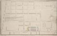
A plan of the City's Estate in Tottenham Court Road
This plan shows a proposed new street near Bedford Square on land owned by the City of London.In the notes on the left side of the sheet the rationale behind the different colours is explained.Gentlemen's houses are to be built with gardens, at the opposite end of which will be houses for shopkeepers.The shops will have large fronts opening on to Tottenham Court Road.The rear wall of the shop keepers houses are to have no lights or other openings, presumably so as not to overlook the gardens of the gentlemen. Metcalf, R.
A MAPP of the PARISH of ST GILES'S in the Fields taken from the last Servey, with Corrections and Additions 1-A
1 : 2748 Plan of the parish of St Giles's from the 1720 edition of Stowe's Survey of England. The plan features title in banner at top left, reference table down the right side of the plate, with compass and scale bar at bottom left. The boundaries of the parish are indicated by a pecked line. Blome, Richard
A Plan of the intended IMPROVEMENTS, on the Estate of his Grace the Duke of BEDFORD. 1800 16
1 : 2784 The area of Bloomsbury represented in this plan has been part of the metropolitan estate of the Russell family, the Earls and Dukes of Bedford since the 17th century. Many of the names of the streets and squares reflect this connection. The plan shows the old British Museum simply marked ''museum'', Russell Square, Brunswick Square, Tavistock Square, Nursery Ground are all indicated as green spaces. Bloomsbury square is marked by a pecked line and coloured green. Bedford house has become Bedford Place, constructed in 1801-5 by James Burton. Under the 6th Duke of Bedford the area was developed north and east, principally by James Burton and Thomas Cubitt. The resulting squares became a favourite area for writers and painters. Neele
London &c. actually survey'd by Wm. Morgan
Ogilby, John
To the Most Noble JOHN, DUKE OF BEDFORD. This Plan of the United Parishes of ST. GILES in the FIELDS & ST. GEORGE, BLOOMSBURY, 4
1 : 444 This map is dedicated to the Duke of Bedford as this area was the primary metropolitan estate of the Earls ans Dukes of Bedford. Russell was the family name of the Dukes of Bedford, hence Russell Square. Bedford house, built for the 3rd Earl of Bedford in 1586, lay adjacent to Montague house, later to be the British Museum, until 1705-6 when it was demolished. In the lower left hand corner is a vignette of a statue of a Duke of Bedford. A birds eye view of the British Museum and a view of the College of Surgeons are also included as is a statue of C.J Fox right hon, the orator. Wyld, James
Plan OF THE PARISHES OR DIVISION OF St Giles in the Fields And ST. GEORGE, BLOOMSBURY. 1815 2
1 : 2400 Different pastel colours describe the Parish divisions within St. Giles in the Fields and St. George's, Bloomsbury. A plan of the Burial Ground and Chapel of St. Giles in the Field, adjoining the church yard of St Pancreas, is located in a separate border. Montagu House was sold in 1755 to house the British museum. It was demolished to make way for Smirke''s building in the 1840''s. Hewitt, N.R.
Insurance Plan of London Vol. VIII: Key Plan
1 : 480 This "key plan" indicates coverage of the Goad 1888 series of fire insurance maps of London that were originally produced to aid insurance companies in assessing fire risks. The building footprints, their use (commercial, residential, educational, etc.), the number of floors and the height of the building, as well as construction materials (and thus risk of burning) and special fire hazards (chemicals, kilns, ovens) were documented in order to estimate premiums. Names of individual businesses, property lines, and addresses were also often recorded. Together these maps provide a rich historical shapshot of the commercial activity and urban landscape of towns and cities at the time. The British Library holds a comprehensive collection of fire insurance plans produced by the London-based firm Charles E. Goad Ltd. dating back to 1885. These plans were made for most important towns and cities of the British Isles at the scales of 1:480 (1 inch to 40 feet), as well as many foreign towns at 1:600 (1 inch to 50 feet). Chas E Goad Limited Chas E Goad Limited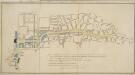
PLAN, presented to the House of Commons, of a STREET proposed from Charing Cross to Portland Place, leading to the Crown Estate in Mary-le-Bone Park
1 : 3684 This original design for Regent Street was commissioned by the House of Commons.The title appears along the top, with a descriptive note below the plan and a scale bar at the bottom centre. Crown Property is highlighted in blue.Starting at Carlton House, Regent Street ran through crownland at Piccadilly (where a circus was built) before turning north-west along Swallow Street, in Soho, finally joining Portland Place north of Oxford Street. Basire, James
Collins' Illustrated Atlas of London with 7000 references, in 36 plates of the principal routes between St. Paul's and the suburbs, from a survey made expressly for this work, by R. Jarman

PLAN OF A Street Proposed FROM CHARING CROSS TO PORTLAND PLACE.
1 : 6000 This is Nash's original design for Regent Street.The title appears at top right, with compass star and scale bar at the bottom left. The course of the street highlighted in yellow, with Crown property is highlighted in blue.Starting at Carlton House, Regent Street ran through crownland at Piccadilly (where a circus was built) before turning north-west along Swallow Street, in Soho, finally joining Portland Place north of Oxford Street. Thompson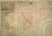
A PLAN OF HIS MAJESTY'S BAYLIWICK OF ST. JAMES IN THE COUNTY OF MIDDLESEX
1 : 2400 This drawn survey of the West of London extends from Knightsbridge to Temple Bar and from Marylebone Gardens to Buckingham Palace. Buildings are indicated in red, open spaces and park land in green and watercourses in blue. Symbols are used to distinguish land use. Gough, William
Vrbium Londini et West-Monasterii nec non suburbii Southwark accurata ichnographia, 1
1 Blatt : 52 x 64 cm Homännische Erben
A New and Exact Plan of the City of LONDON and Suburbs thereof, With the addition of the New Buildings, Churches &c. to this present Year 1720 (Not extant in any other)
1 : 6336 This map of the West End of London is part of Henry Overton's complete map of London and its suburbs, published in 1720.The title and publisher's imprint appear in cartouche in the centre, with fares of hackney coaches and an overall key at bottom left. The compass rose appears in the river, with parish boundaries outlined in colour. Henry Overton took over his father John's publishing business in 1707 and continued to publish maps from the same address at White Horse near Newgate. Overton, Henry
A new and exact plan of the city of London and suburbs thereof, 1
1 Blatt : 60 x 52 cm Henry Overton
LONDON and WESTMINSTER in the Reign of QUEEN ELIZABETH Anno Dom. 1563
This is a retrospective map of Elizabethan London, giving us an idea of how people in the late 18th Century viewed the Elizabethan capital. The present-day Covent Garden is an area of fields named "Convent Garden”, indicating that the area belonged to the Abbey of St Peter's at Westminster before the dissolution of monasteries in the reign of Henry VIII. The location of Tower Bridge is marked, although the actual bridge was not planned until 1879. This indicates that Londoners were thinking about bridging the river at this point one hundred years before the decisive plan to do so. Wallis, J.
LONDON and WESTMINSTER in the Reign of QUEEN ELIZABETH, Anno Dom. 1563 25
This retrospective map of Elizabethan London was produced in the 1820s. It provides us with an idea of how people in the19th century viewed the Elizabethan city. The location of Tower Bridge is indicated on this map, even though plans for the actual bridge were not made until 1879. Neele, George
NEW and ACCURATE PLAN of the CITY of WESTMINSTER, The DUTCHY of LANCASTER and Places Adjacent
1 : 11520 The title of this map appears in cartouche at top right, with a compass rose at top left. A territory with its own courts and administration, the Duchy of Lancaster was created in 1267 by Edward III for his younger son John. The Duchy was attached to the Crown when Prince Henry of Bolingbroke, the last Duke of Lancaster, became Henry IV in 1399. To this day, the Duchy has retained its own jurisdiction under the Chancellor of the Duchy of Lancaster.The chancellorship is a high governmental position, and sometimes a cabinet poist. Since, for at least the last two centuries, the Chancellor rarely has had any significant duties pertaining to the Duchy's management, he is usually available as a minister without portfolio. Recent Chancellors have included Labour cabinet minister Mo Mowlam.
A NEW and ACCURATE PLAN of the CITY of WESTMINSTER The DUTCHY of LANCASTER and Places Adjacent
John Rocque developed his surveying talent at a young age, making plans of the great houses and gardens of the nobility.This early experience led to him taking up large-scale surveying, producing plans such as this one of Westminster. Here, Tottenham Court and Marylebone are mostly fields but Westminster has grown sufficiently to demand the construction of a new bridge.Westminster Bridge was opened in 1750 and watermen were paid 163;25,000 in compensation as the new bridge made them largely redundant. The Chelsea Water Works Company, shown south of Totthill Fields, was set up to improve water supply to Westminster and "parts adjacent".The Company were the first to introduce slow sand filtration to purify Thames water. Rocque, John
London VII.SW - OS Six-Inch Map
1 : 10560 Topographic maps Ordnance Survey Ordnance Survey
FORD'S ILLUSTRATED MEMORIAL OF THE GRAND INDUSTRIAL EXHIBITION OF ALL NATIONS, HYDE PARK, LONDON 1851
This pictorial map commemorates the Great Exhibition of 1851, conceived by Henry Cole and presided over by Prince Albert. Theexhibition was held in the Crystal Palace. Designed by Joseph Paxton, it showcased exhibits from all over the world, including the largest pearl ever found, a knife with 300 blades, and the Koh-i-Noor diamond. The exhibition was opened by Queen Victoria in May 1851. She remained a frequent visitor, as did the Duke of Wellington. Only main roads in the capital are shown on this map and London locations are marked by small medallions containing scenes. Borders of roundels contain people from "all nations". Queen Victoria and Albert flank a view of the Crystal Palace, which was removed from Hyde Park in 1852andrebuilt at Sydenham. Simpson Ford, William
Surrey III.NW - OS Six-Inch Map
1 : 10560 Topographic maps Ordnance Survey Ordnance Survey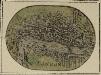
LONDON 20
A miniature map of London and Westminster with title at the foot of the plate and areas outside the built-up area coloured green.
Ordnance Survey of London Skeleto
Ordnance Survey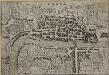
LONDRA
This small Italian etching is one of the earliest surviving maps of the city of London. It appeared in a book by Francesco Velagio entitled 'Raccolta di le piu` illustri et famose citta di tutto il mondo'. Published in Venice around 1595, the book depicts the main Italian and European cities. The map was copied for a fresco in a church in the Italian city of Mantua. Velagio, Francesco
![Plan of the British Museum as built by Sir Smirke, Robert. Ground Floor] 20-](https://images-2.georeferencer.com/images/iiif/875763345083/full/,300/0/native.jpg)

