Maps of Westminster
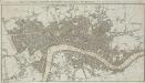
An IMPROVED PLAN of the CITIES of LONDON and WESTMINSTER and BOROUGH of SOUTHWARK, including the NEW BUILDINGS, ROADS &C.
This coloured map shows the built-up area of the City of London as a stippled pattern, with other built-up areas crosshatched. This map is a later edition of Kitching and Parker's 1765 plan, updated to include the new bridge and the approaches at Blackfriars as finally laid out. Designed by Robert Mylne, this third bridge spanning the Thames was built between 1760 and 69. The nine semi-elliptical Portland stone arches were replaced from 1860 to 69 by the present structure of five wrought-iron arches each faced with cast iron, and a granite pier designed by Cubitt and Carr. Kitching, Thomas and Parker, Henry
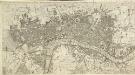
THE CITY GUIDE OR POCKET PLAN OF LONDON, WESTMINSTER And SOUTHWARK With the New Buildings to the Year 1765 121
The title of this map of London runs along the top, with built-up areas represented by stippling within the city boundaries, and hatched elsewhere. Fields and open spaces are shown in green. This first edition of the map does not show the new bridge at Blackfriars, added to the later editions. Bowles, John & Thomas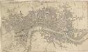
THE CITY GUIDE OR POCKET PLAN OF LONDON, WESTMINSTER And SOUTHWARK With the New Buildings to the Year 1765 125
The title of this pocket map runs along the top, with the publisher's imprint below the plan. Built-up areas in the City of London are represented by stippling, and by crosshatching outside the city. The map is a later edition Bowles' 1761 plan, with the addition of Queen Anne's Square and Portman Square in Marylebone and the new bridge and approaches at Blackfriars. Designed by Robert Mylne, this third bridge spanning the Thames was built between 1760 and 69. The nine semi-elliptical Portland-stone arches were replaced from 1860 to 69 by the present structure of five wrought-iron arches, each faced with cast iron, and a granite pier designed by Carr and Cubbitt. Bayly, J.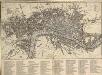
An IMPROVED PLAN of the CITIES of LONDON and WESTMINSTER and BOROUGH of SOUTHWARK, including the NEW BUILDINGS, ROADS &C. to the Present Year 1765.
The title of this pocket map appears along the top, with built-up areas represented by stippling in the City of London, and crosshatching elsewhere. A table of reference appears in a panel below the plan. The map, a later edition of Kitching and Parker's 1765 plan, shows the new bridge and the approaches at Blackfriars. Designed by Robert Mylne, this third bridge spanning the Thames was built between 1760 and 69. The nine semi-elliptical Portland stone arches were replaced from 1860 to 69 by the present structure of five wrought-iron arches each faced with cast iron, and a granite pier designed by Cubitt and Carr. Kitching, Thomas and Parker, Henry
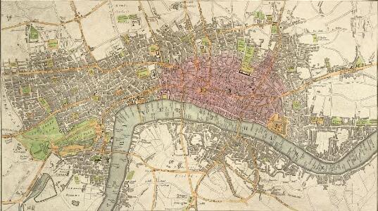
The LONDON DIRECTORY, or a New & Improved PLAN of LONDON, WESTMINSTER, & SOUTHWARK; 152
Robert Laurie was a fine mezzotint engraver and regular exhibitor at the Society of Artists in the 1770s. He acquired the stock of surveyor John Sayer’s in 1794 and, in partnership with James Whittle, founded the map publishing firm Laurie & Whittle. This map is very similar to the 1765 map by Robert Sayer and is probably from the same plate. Blackfriars Bridge is shown along with its proposed approaches. Laurie, Robert, and Whittle, James.
The LONDON DIRECTORY, or a New & Improved PLAN of LONDON, WESTMINSTER, & SOUTHWARK
This is the fifth edition of a map originally published in 1771 by John Bowles. His name has been replaced by the imprint of Robert Wilkinson, the reissuer. This map highlights the London Wall in red, and colours the city in pink. It uses arrows to show the direction of water-flow in the Thames. There are some additions to the map near Foundling Hospital. Bowles, John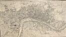
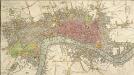
A NEW and Correct PLAN OF THE CITIES AND SUBURBS OF LONDON & WESTMINSTER & BOROUGH OF SOUTHWARK with the COUNTRY adjacent, the NEW BUILDINGS, ROADS &c. to the Year 1766
The title of this map runs along the top of the plan, which shows the new bridge at Blackfriars as "Pitt's Bridge". Designed by Robert Mylne, this third bridge spanning the Thames was built between 1760 and 69. The nine semi-elliptical Portland stone arches were replaced in a hundred years later by the present structure of five wrought-iron arches faced with cast-iron, and a granite pier designed by Cubitt and Carr. Gibson, John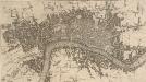
A NEW and Correct PLAN of LONDON WESTMINSTER and SOUTHWARK with the New Buildings to the Year 1770
This map was published in 'A new and complete history and survey of the cities of London and Westminster... revised by Henry Chamberlain.' Only one edition was published and some copies omit the name of the engraver, J. Flyn. The Chelsea Waterworks are shown in Hyde Park. This was the first water-plant to use slow sand filtration to purify the water it supplied. Flyn, J.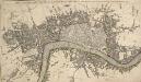
THE CITY GUIDE OR POCKET PLAN OF LONDON, WESTMINSTER And SOUTHWARK with the New Buildings to this Present Year 1764
This pocket map of London based on Rocque's map of 1748.Thetitle appears along the top, with the built-up area in the City of London described by stippling, and other built-up areas by crosshatching. The city boundaries are outlined in colour. The map shows the proposed new bridge at Blackfriars, but not the approaches. Designed by Robert Mylne, this third bridge to span the Thames was built between 1760 and 69. The nine semi-elliptical Portland-stone arches were replaced from 1860 to 69 by Cubitt and Carr’s present structure of five wrought-iron arches faced with cast iron and a granite pier.
The LONDON DIRECTORY, or a New & Improved PLAN of LONDON, WESTMINSTER & SOUTHWARK;
The title of this map appears along the top, with a key in panel below the plan and letters along the borders for reference. Sayer's maps of London, largely derivative, were issued with few alterations throughout the middle years of the 18th Century. This is a later edition of a map he first published in 1765, updated to include the approaches to Blackfriars Bridge, which did not feature in the first edition. Sayer, Robert
The LONDON DIRECTORY, or a New & Improved PLAN of LONDON,
Robert Sayer, the surveyor, traded as a map publisher and print seller in Fleet Street in the latter half of the 18th Century. Between 1751 and 1770and againfrom1784to 1794, he published maps under his own name or under the imprint of Sayer and Bennett. This is the 11th edition of a map published 14 times over a period of 27 years. During this time Robert Sayer became joined in partnership with John Bennett, with their joint imprint appearing on the third to eighth editions. The area of the city is highlighted in pink. A table of references for churches and public buildings appears below the map. In 1794 Sayers stock was acquired by Robert Laurie who founded the map publishing firm of Laurie & Whittle, with his friend James Whittle. Sayer, Robert
The LONDON DIRECTORY, or a New & Improved PLAN of LONDON, WESTMINSTER, & SOUTHWARK; 182
This map is a reissue of a map published in 1771 by John Bowles. Bowles's name has been replaced by that of Robert Wilkinson, the reissuer. A table of references to churches and public buildings appears below the map. The built-up area of the city is stippled, with other built-up areas done in crosshatching. Coloured lines delineate individual city wards. Bowles, John
The LONDON DIRECTORY, or a New & Improved PLAN of LONDON, WESTMINSTER, & SOUTHWARK; 157
This is the eighth edition of the an original 1765Sayer map. Bennett’s name was added to the imprint of the third edition of the map, published in 1776. The two men were in partnership between 1770 and 1787.Their business was taken over by Laurie and Whittle in 1792. R. Sayer & J. Bennett
The LONDON DIRECTORY, or a New & Improved PLAN of LONDON, WESTMINSTER, & SOUTHWARK;
This is a reissue of a map first published in 1771 by John Bowles. Bowles' name has been removed, with the imprint of there issuer, Robert Wilkinson, appearing instead. This map highlights the London Wall in red, showing with arrows the direction of water-flow in the Thames. Bowles, John
BOWLES'S Reduced NEW POCKET PLAN of the CITIES of LONDON and WESTMINSTER, with the BOROUGH of SOUTHWARK, exhibiting the NEW BUILDINGS to the YEAR 1783.
Carrington Bowles (1724-93) came from a family of publishers and map sellers who published a considerable body of work during a century of trading. This is the fifth edition of an original 1777map. It includes a table of references to churches and principal buildings. The built-up areas of the City of London are stippled, with the city and county boundaries delineated by coloured lines. The scale is given in miles or furlongs in the bottom right-hand corner. Carrington Bowles
Plan of London, Westminster & Southwark
The LONDON DIRECTORY, or a New & Improved PLAN of LONDON, WESTMINSTER & SOUTHWARK; with the adjacent Country
The title of this folding map appears along the top. The plan shows Blackfriars Bridge, which was under construction between 1760 and 1769. There is uncertainty about the date of this map. It is very similar to the 1765 map by Robert Sayer and was probably produced from the same plate. Laurie& Whittle took over Sayer's stock in 1792, making an earlier publication date very unlikely. Laurie, Robert, and Whittle, James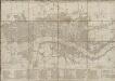
BOWLES'S Reduced NEW POCKET PLAN of the CITIES of LONDON and WESTMINSTER, with the BOROUGH of SOUTHWARK, exhibiting the NEW BUILDINGS to the YEAR 1787.
This is the sixth edition of Bowles's Reduced New Pocket Plan. The map was reissued 11 times between1777 and 1799. It includes a table of references to churches and principal buildings. The built-up areas of the City of London are represented by stippling; with the city boundaries delineated it red. The scale is given in miles and furlongs. Bowles, Carington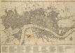
BOWLES'S Reduced NEW POCKET PLAN of the CITIES of LONDON & WESTMINSTER; WITH THE BOROUGH OF SOUTHWARK, exhibiting the New Buildings to the YEAR 1780
The Bowles family were successful map publishers and sellers whose considerable output spanned a century. This map is the second edition of an original 1777plan. It includes a table of references to churches and principal buildings. The built-up areas of the City of London are stippled. The scale is given in miles or furlongs. Bowles, Carington
HARRIS'S PLAN of LONDON, WESTMINSTER and the BOROUGH of SOUTHWARK, with all the additional Streets, Squares &c; also the improved ROADS to the Year 1794.
This map is the seventh edition of an original plan of1779. Differences between the fifth and sixth edition five suggest that the plate was re-engraved, at least in parts, as additional buildings appear in the sixth edition, dating from 1791.This edition claims to show London as it was in 1794, although no discernible features distinguish it from the previous edition. An alphanumeric table of references and a grid of half-mile squares aids orientation. A small diagram in the bottom right corner instructs the user on how to use the grid. The bottom margin has been trimmed away, removing the print seller's imprint. Harris, John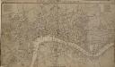
LONDON, WESTMINSTER AND SOUTHWARK, Accurately delineated from the latest Surveys,
John Cary was possibly the most productive maker and publisher of maps in England the 18 Century. His works were reissued many times, but unlike many of his contemporaries he aimed to update each new edition by including new developments. This is the second edition of a map originally published in 1782. The imprint and table of Hackney coach fares (referred to in the description) has been removed from the bottom of the map. Cary, John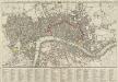
A new Pocket Plan of LONDON WESTMINSTER and SOUTHWARK, with all the Adjacent Buildings. Also a correct List of upwards of 300 Hackney Coach Fares 1797.
Pocket plans were made popular by publisher Thomas Bowles in the 1730s. This later map is coloured to highlight the old London Wall and the parks and open spaces. This map includes a list of Hackney Coach Fares. The development of turnpike roads from the 1750s onwards led to a steady increase of wheeled vehicles such as the Hackney Coach, which eventually made watermen redundant Darton, William and Harvey, Josiah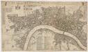
A new mapp of the city of London &c. : with the many additionall buildings and new streets anno 1723 in a playne
1 : 7300 Taylor, Thomas, fl. 1670-1730 Printed and sold by Thomas Taylor at the Golden Lyon in Fleet Street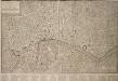
PLAN OF LONDON WESTMINSTER and the BOROUGH of SOUTHWARK with all the additional Streets, Squares, & c also the improved ROADS to the Year (1772) From the best Authors.
This map includes Finsbury Fields and Newington. Field boundaries are indicated. A table of references for public buildings is included. Buildings are shown in plan form. The internal structures of the Tower of London are detailed. Bonnisselle, J.G.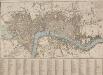
A NEW PLAN OF LONDON with the Names of the Streets Alphabetically arranged at Bottom with directions to find them in the Map
The title of this map appears along the top and with the river, city boundaries and open spaces depicted in different colours. The map is divided into numbered squares for reference, with a key in the table below the plan. Samuel Fores, better known as a publisher of sporting prints, first issued this map in 1789; this is a later edition, updated to include the housing developments of Sommers Town and St. George's Field. Fores, Samuel W.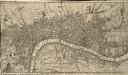
A Correct PLAN of the CITIES of LONDON & WESTMINSTER & BOROUGH of SOUTHWARK, including the BILLS of MORTALITY, with the ADDITIONAL BUILDINGS 118
This map of London was published as supplement to Volume 30 of the 'London Magazine' in 1761. Attributed to John Rocque, the map's title features in a panel below the plan, with the publisher’s imprint along the top. [Rocque, John]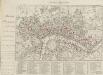
HARRIS'S PLAN of LONDON, WESTMINSTER and the BOROUGH of SOUTHWARK, with all the additional Streets, Squares &c; also the improved ROADS to the Year 1791.
This is the sixth edition of an original 1779map. Differences between this edition and the previous one suggest that the plate was re-engraved, at least in part, as new and proposed buildings have been added. Most strikingly, 20 proposed locations for fire stations are depicted, along with their catchment areas. The Metropolitan Fire Brigade was not formed until 1865. A number of different company brigades had co-operated with each other as the London Fire Engine Establishment since 1833. The failure of this service to stop the destruction of the Houses of Parliament in 1837led to criticism, increasing when a fire in Tooley Street raged for two days. Harris, John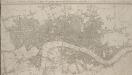
A New & accurate PLAN of the CITIES of LONDON, WSTMINSTER & BOROUGH of SOUTHWARK with the Out Parts & New Buildings completed to the Year 1792.
Samuel Neele came from a family of engravers. This map was issued twice in two years with no discernible difference between editions, except the date in the title. This is the second edition. It has been cropped and thus is missing its imprint. Neele, Samuel J.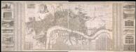
A New & Exact Plan of the Cities of London, & c.
Map of London with title along the top, arms of the 12 principal livery companies at top left with City arms and emblems of the arts. Lists of wards and parishes are reported in a table at bottom left and a descriptive note near bottom centre, with fares of coaches and ferries at bottom right. Down both sides of the map are views of prominent buildings: St Paul's Cathedral, the Banqueting House, the Royal Exchange, Custom House, the Admirably Office, the Royal Palace at St James', Westminster Abbey, Guildhall, the Bank of England, the Tower of London, the Treasury and South Sea House. Foster, George