Maps of Westminster
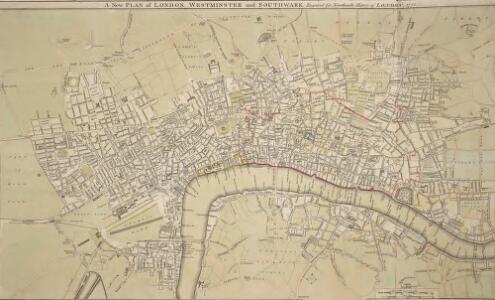
A New PLAN of LONDON WESTMINSTER and SOUTHWARK Engraved for Noorthouck's
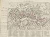
This map highlights in red the boundaries of the old London Wall, built by the Romans. By the end of the 17th Century it had become an anachronistic nuisance. The first section (near Bishops Gate) was removed in 1707 and much of the rest was broken down or built over during the 18th Century. Most of the gates were pulled down in 1760/1, wtih Newgate, the last to survive, demolished in 1777. Noorthouck, John
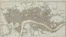
AN ENTIRE NEW PLAN OF THE CITIES OF LONDON AND WESTMINSTER WITH THE BOROUGH OF SOUTHWARK 205
The title and imprint of this folding map of London appear in a table at the top left, facing an advertisement for Mogg's "Survey of the Roads" at the top right. A compass star and scale bar feature at the bottom right. The river, open spaces and city boundaries are distinguished by colour use. A derivative of Cary’s plan of 1790, twenty editions of this map were published between 1803 and 1828. Mogg, Edward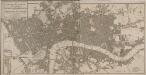
AN ENTIRE NEW PLAN OF THE CITIES OF LONDON AND WESTMINSTER WITH THE BOROUGH OF SOUTHWARK 217
This map of London comprises two sheets with the title and imprint at top left, a compass star at top right and scale bar and explanatory note at the bottom right. This is a later edition of a map first published by Mogg at the beginning of the 19thCentury, updated to include Waterloo Bridge and Waterloo Bridge Road. Mogg, Edward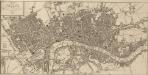
Plan von London und Westminster mit der Borough von Southwark
The LONDON DIRECTORY, or a New & Improved PLAN of LONDON, WESTMINSTER & SOUTHWARK; with the adjacent Country
The title of this folding map appears along the top. The plan shows Blackfriars Bridge, which was under construction between 1760 and 1769. There is uncertainty about the date of this map. It is very similar to the 1765 map by Robert Sayer and was probably produced from the same plate. Laurie& Whittle took over Sayer's stock in 1792, making an earlier publication date very unlikely. Laurie, Robert, and Whittle, James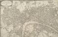
WALLIS'S PLAN of the CITIES of LONDON and WESTMINSTER 1797
This is the first edition of a map published seven times over a period of 16 years. This plan has been physically trimmed resulting in the loss of some information. The scale bar and list of Hackney coach fares would have been to the bottom right. Wallis, John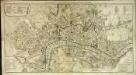
Neuester Grundriss von London, Westminster, und Southwark
1 Plan : Kupferdruck ; 36 x 67 cm Liebe s.n.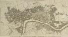
A NEW and Complete PLAN of LONDON WESTMINSTER and SOUTHWARK, with the Additional Buildings to the Year 1777.
The title of this small map of London appears in a panel below the plan. The built-up of the city is stippled while other built-up areas are hatched. This map was first issued as frontispiece to Book III of Walter Harrison's 'A New and Universal History, Description and Survey of the Cities of London and Westminster', 1776. Harrison, Walter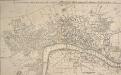
A New and Accurate PLAN of the CITIES of LONDON AND WESTMINSTER, including the NEW ROADS & NEW BUILDINGS. 1765
This map shows the London, Westminster and Blackfriars bridges across the Thames, marking the many stairways down to the water necessary before the bridges were built.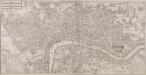
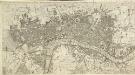
A NEW PLAN OF LONDON AND WESTMINSTER WITH THE BOROUGH OF SOUTHWARK 218
Map of London with the title in a panel at top left, imprint below the plan, key to colours at bottom centre, a scale bar at bottom right and with a list of parishes in tables near bottom left and bottom right. The map is divided into furlong squares printed in red ink and features numbers along the borders for reference. The son of a map publisher, James Wyld attended military college before entering the map trade. He became one of the best-known map publishers of the middle of the 19th Century and during the railway-building mania of those years, his maps of railway developments were often put before parliament. Wyld, James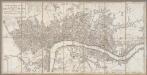
A new pocket plan of the cities of London & Westminster with the Borough of Southwark : comprehending the new buildings and other alterations to the year 1789
1 : 9000 Annotatie: Met administratieve indeling en lijst van belangrijke gebouwen London : Faden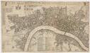
A new mapp of the city of London &c. : with the many additionall buildings and new streets anno 1723 in a playne
1 : 7300 Taylor, Thomas, fl. 1670-1730 Printed and sold by Thomas Taylor at the Golden Lyon in Fleet Street
The LONDON DIRECTORY, or a New & Improved PLAN of LONDON, WESTMINSTER, & SOUTHWARK; 182
This map is a reissue of a map published in 1771 by John Bowles. Bowles's name has been replaced by that of Robert Wilkinson, the reissuer. A table of references to churches and public buildings appears below the map. The built-up area of the city is stippled, with other built-up areas done in crosshatching. Coloured lines delineate individual city wards. Bowles, John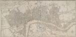
BOWLES'S NEW POCKET PLAN OF THE CITIES OF LONDON & WESTMINSTER; WITH THE BOROUGH OF SOUTHWARK: Comprehending the New Buildings and other Alterations to the Year 1780
This map was printed for Caringtom Bowles who traded from a St. Paul's churchyard. The Bowles family were not cartographers but published and sold maps. This is the fourth edition of a map originally issued in 1773.The title is at top left, next to a list of parishes, with a key to Great Offices of State and Westminster parishes down the left of the plate. The border of the map is marked off in miles and furlongs. There is no discernible difference between this edition and the previous ones. Bowles, Carington
The LONDON DIRECTORY, or a New & Improved PLAN of LONDON, WESTMINSTER, & SOUTHWARK;
This is a reissue of a map first published in 1771 by John Bowles. Bowles' name has been removed, with the imprint of there issuer, Robert Wilkinson, appearing instead. This map highlights the London Wall in red, showing with arrows the direction of water-flow in the Thames. Bowles, John
NEW PLAN OF LONDON
This map was printed in black on white and appeared in the “Guide to Knowledge" anthology of 1839. The map's title, imprint and scale bar appear at bottom right. It shows the proposed Thames Tunnel, linking Wapping and Rotherhithe, as well as the Hungerford Bridge and the Greenwich and Birmingham railway lines. Archer, Joshua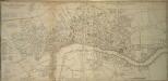
A NEW PLAN of the CITY AND LIBERTY of WESTMINSTER
The engraver-turned-cartographer Thomas Jeffrey began commissioning original surveys for a series of English county maps in the early 1760s. This is the combination of two separate maps: a map of Westminster, with a list of districts and parishes in the County of Middlesex; and an adjoining map of London featuring list of parishes in the County of Surrey and key to colours. The map is a later edition of Jeffrey's map of 1766, with the imprint, dedication and City arms omitted, updated to include the New Road, the first London bypass, and the roads across St. George's Fields. Jeffrey, Thomas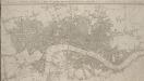
A New & accurate PLAN of the CITIES of LONDON, WSTMINSTER & BOROUGH of SOUTHWARK with the Out Parts & New Buildings completed to the Year 1792.
Samuel Neele came from a family of engravers. This map was issued twice in two years with no discernible difference between editions, except the date in the title. This is the second edition. It has been cropped and thus is missing its imprint. Neele, Samuel J.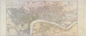
A NEW POCKET PLAN OF THE CITIES OF LONDON & WESTMINSTER WITH THE BOROUGH OF SOUTHWARK
This folding map of London is the eighth edition of a map first published by Faden in 1787. It features title at top left, table of parishes next to the title, and scale bar at bottom right. At bottom centre is a list of Surrey parishes within the Bill of Mortality - the name given to the areas from which the London government received regular death notices. The border of the map is divided in miles and furlongs. At the beginning of the 19th Century, the administration of London was split among a multitude of authorities, vestries, special commissions and private enterprises. The nine districts in London are distinguished on the map by areas of different colour, with key to colours and explanation of the relevant civil and military authorities in handwritten notes down both sides of the map. Faden, William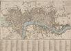
A NEW PLAN OF LONDON with the Names of the Streets Alphabetically arranged at Bottom with directions to find them in the Map
The title of this map appears along the top and with the river, city boundaries and open spaces depicted in different colours. The map is divided into numbered squares for reference, with a key in the table below the plan. Samuel Fores, better known as a publisher of sporting prints, first issued this map in 1789; this is a later edition, updated to include the housing developments of Sommers Town and St. George's Field. Fores, Samuel W.
The LONDON DIRECTORY, or a New & Improved PLAN of LONDON,
Robert Sayer, the surveyor, traded as a map publisher and print seller in Fleet Street in the latter half of the 18th Century. Between 1751 and 1770and againfrom1784to 1794, he published maps under his own name or under the imprint of Sayer and Bennett. This is the 11th edition of a map published 14 times over a period of 27 years. During this time Robert Sayer became joined in partnership with John Bennett, with their joint imprint appearing on the third to eighth editions. The area of the city is highlighted in pink. A table of references for churches and public buildings appears below the map. In 1794 Sayers stock was acquired by Robert Laurie who founded the map publishing firm of Laurie & Whittle, with his friend James Whittle. Sayer, Robert
BOWLES'S Reduced NEW POCKET PLAN of the CITIES of LONDON and WESTMINSTER, with the BOROUGH of SOUTHWARK, exhibiting the NEW BUILDINGS to the YEAR 1783.
Carrington Bowles (1724-93) came from a family of publishers and map sellers who published a considerable body of work during a century of trading. This is the fifth edition of an original 1777map. It includes a table of references to churches and principal buildings. The built-up areas of the City of London are stippled, with the city and county boundaries delineated by coloured lines. The scale is given in miles or furlongs in the bottom right-hand corner. Carrington Bowles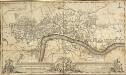
A PLAN of the CITIES of LONDON and WESTMINSTER with the BOROUGH of SOUTHWARK
The border of this folding map is divided in degrees of latitude and longitude with a scale bar at bottom right. The title of the map is in a panel below the plan with the arms of the City, flanked by the arms of Westminster (left) and Bridge House (right). Bridge House was responsible for the upkeep and maintenance of all bridges within the City of London. A freeman with the Clothworkers Company, William Faden became Jeffrey's business partner in the 1770s, taking control of the publishing and printing businesson Jeffrey's death. Jeffrey, Thomas & Faden, William
Plan of London, Westminster & Southwark
A New & accurate PLAN of the CITIES of LONDON, WSTMINSTER & BOROUGH of SOUTHWARK with the Out Parts & New Buildings completed to the Year 1791.
Born into a family of engravers, Neele issued this map twice in two years with no discernible difference between the editions. The map's title features along the top, with scale bar at upper right and publisher's imprint below the plan. City boundaries are outlined in red; squares and open spaces are highlighted in green. Neele, Samuel John
The LONDON DIRECTORY, or a New & Improved PLAN of LONDON, WESTMINSTER, & SOUTHWARK; 157
This is the eighth edition of the an original 1765Sayer map. Bennett’s name was added to the imprint of the third edition of the map, published in 1776. The two men were in partnership between 1770 and 1787.Their business was taken over by Laurie and Whittle in 1792. R. Sayer & J. Bennett
The LONDON Guide or A Pocket Plan of the CITIES of LONDON, WESTMINSTER and borough of SOUTHWARK for the Universal Scots ALMANACK, with the New Buildings 1781.
This is a map from the Universal Scots Almanack. The area of the city is left white in comparison to the surrounding area, providing us with a rough outline of where the old London wall enclosed the city. By 1781, the date of this map, this Roman wall had been entirely demolished or built over. Most of the gates were pulled down in 1760/1. Newgate was the last to be demolished, surviving until 1777. UNIVERSAL SCOTS ALMANACK
The LONDON DIRECTORY, or a New & Improved PLAN of LONDON, WESTMINSTER & SOUTHWARK;
The title of this map appears along the top, with a key in panel below the plan and letters along the borders for reference. Sayer's maps of London, largely derivative, were issued with few alterations throughout the middle years of the 18th Century. This is a later edition of a map he first published in 1765, updated to include the approaches to Blackfriars Bridge, which did not feature in the first edition. Sayer, Robert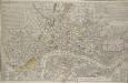
A NEW and CORRECT PLAN of the CITIES of LONDON, WESTMINSTER, and BOROUGH of SOUTHWARK wherein all the Streets, Roads, Churches, Public Buildings &c. to the Present Year 1791 are exactly delineated.
Map publisher and print seller Robert Sayer traded from Fleet Street in the latter half of the 18th century, first under his own name, and then under the joint imprint of Sayer& Bennett. This map has four-colour text panels in corners, including information relating to the recent Act for regulating Hackney Coaches. The development of turnpike roads in 1750 saw an increase of wheeled traffic, supplanting rivers as the main medium of transport. The map also features information about new rates for watermen introduced in 1785.The title of the plan states that it has been published as the "Act Directs”, a reference to the Copyright Act of 1734, used to curb the high incidence of uncredited copying among mapmakers. Sayer, Robert