Maps of London

THE WEST PART OF THE RIVER THAMES and THE EAST PART OF THE RIVER THAMES
The title of this map of the course of the River Thames (from its spring in Gloucestershire to its estuary)runs along the top, with a scale bar at bottom centre and a key to docking reaches at top right. Geographical features and built-up areas are indicated by symbols, with the water soundings expressed in feet at various points of the estuary. Harris, J.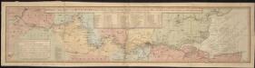
Bowles's new map of the River Thames, from it's spring in Gloucester-shire, to it's influx into the sea, with a table of all the locks, wears, and bridges thereupon, shewing the tolls payable at each and their distance by water from one another
1 : 1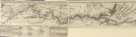
A Draught of the RIVER THAMES from its Spring in GLOUCESTERSHIRE to its Influx into the SEA
The title of this map of the River Thames' course runs along the top, with a scale bar at bottom centre. A note below the plan gives an account of the geographical features of the river, with a table indicating distances and fares of barges between points of navigation. A second note gives instructions on docking for goods coming from overseas with key to docking reaches at top right. Geographical features and built-up areas are indicated by symbols, with the soundings of the water expressed in feet at various points along the river. Bowles, Thomas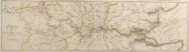
Plan of the RIVER THAMES
The title of this map of the course of the River Thames' course (running from its spring in Gloucestershire to the estuary) appears at bottom left next to the scale bar. The course of the river is highlighted in yellow, and different colours used to indicate county borders. Neele, S.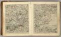
Sheets 25-26. (Cary's England, Wales, and Scotland).
1 : 360000 Cary, John, ca. 1754-1835
Les environs de Londres
1 Karte : Kupferdruck ; 47 x 55 cm Le Rouge par et chez le Sr. le Rouge ingenieur geographe du roi rue des Augustins vis a vis le panier Fleury
A MAP OF THE DIOCESS OF LONDON
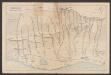
This drawn plan was probably a draught for the map of the Diocese of London published by Jacob Robinson between 1723 and 1748. The title and an explanatory note appear in a square table at the bottom right. The boundaries of the diocese are outlined in red and all the churches within the diocese indicated by a red symbol. Harris, John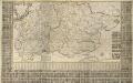
A New and Correct MAPP OF MIDDLESEX, ESSEX AND HERTFORDSHIRE With the Roads Rivers Sea-Coast ACTUALLY SURVEYED
Based on an original survey of 1721, this map of Hertfordshire, Middlesex and Essex was first issued in 1724. It was still being offered for sale by Bowles& Carver at the end of the 18th Century. Printed in six sheets, the map's title appears in ornamental cartouche at top left, with compass star at bottom right, key to symbols at bottom left and a list of towns and villages in a panel below the plan. Down both sides of the map and along the bottom are 850 coats of arms. A key in the table at bottom centre links them to the homes of their owners, who were also subscribers to the map. County borders are indicated by a discontinuous line, with liberty boundaries (public land) outlined in colour. Warburton, John, Bland, Joseph and Smyth, Pyler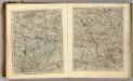
Sheets 23-24. (Cary's England, Wales, and Scotland).
1 : 360000 Cary, John, ca. 1754-1835
Bercheria Vernacule Bark Shire. [Karte], in: Theatrum orbis terrarum, sive, Atlas novus, Bd. 4, S. 186.
1 Karte aus Atlas Blaeu, Joan Blaeu, Willem Janszoon

A New and Exact Map of the DIOCESE OF LONDON
This plan is based on John Harris's similar map of 1714.A dedication to the Lord Bishop of London and diocesan arms appear at the top, surrounded by illustrated views of prominent London churches: St Paul's Cathedral, St. Bridget's, Westminster Abbey and St. Mary-le-Bow. Robinson, Jacob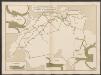
Bercheria Vernacule Barkshire. [Karte], in: Le théâtre du monde, ou, Nouvel atlas contenant les chartes et descriptions de tous les païs de la terre, Bd. 4, S. 164.
1 Karte aus Atlas Blaeu, Willem Janszoon und Blaeu, Joan Blaeu, Willem Janszoon
Essexiae Descriptio. The Description of Essex. [Karte], in: Novus atlas absolutissimus, Bd. 7, S. 265.
1 Karte aus Atlas Janssonius Offizin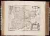
Essexiae descriptio = The description of Essex / [Joannes Janssonius]
1 : 220000 titelvariant: The description of Essex; Annotatie: Oorspr. verschenen in: Ioannis Ianssonii Novus Atlas ... - Amstelodami : apud Iohannem Ianssonium, 1646; Origineel is Blad 28 in atlas factice Janssonius, Joannes (jr.) (1588-1664) Amstelodami : sumptibus Ioannis Ianssonii
Bercheria Vernacule Bark Shire. [Karte], in: Theatrum orbis terrarum, sive, Atlas novus, Bd. 4, S. 186.
1 Karte aus Atlas Blaeu, Joan Blaeu, Willem Janszoon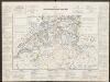
Essexiae Descriptio. The Description of Essex. [Karte], in: Gerardi Mercatoris et I. Hondii Newer Atlas, oder, Grosses Weltbuch, Bd. 1, S. 93.
1 Karte aus Atlas Mercator, Gerhard und Hondius, Jodocus Jansson, Jan
Essexia Comitatus. [Karte], in: Le théâtre du monde, ou, Nouvel atlas contenant les chartes et descriptions de tous les païs de la terre, Bd. 4, S. 244.
1 Karte aus Atlas Blaeu, Willem Janszoon und Blaeu, Joan Blaeu, Willem Janszoon
Glocestria Ducatus; Vulgo Glocester Shire. [Karte], in: Theatrum orbis terrarum, sive, Atlas novus, Bd. 4, S. 228.
1 Karte aus Atlas Blaeu, Joan Blaeu, Willem Janszoon
Glocestria Ducatus; Vulgo Glocester Shire. [Karte], in: Theatrum orbis terrarum, sive, Atlas novus, Bd. 4, S. 228.
1 Karte aus Atlas Blaeu, Joan Blaeu, Willem Janszoon
60. London. The World Atlas.
1 : 250000 USSR (Union of Soviet Socialist Republics).
Essexia Comitatus. [Karte], in: Theatrum orbis terrarum, sive, Atlas novus, Bd. 4, S. 274.
1 Karte aus Atlas Blaeu, Joan Blaeu, Willem Janszoon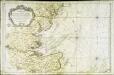
Carte des entrées de la Tamise
1 Karte : Kupferdruck ; 55 x 83 cm Bellin s.n.
Oxonii, buckinghamiae et berceriae comitatum
This is a map of Oxfordshire, Buckinghamshire and Berkshire by Christopher Saxton which dates from 1574. It forms part of an atlas that belonged to William Cecil Lord Burghley, Elizabeth I’s Secretary of State. Burghley used this atlas to illustrate domestic matters. This map is actually a proof copy of one which forms part of Christopher Saxton’s Atlas of England and Wales. This atlas was first published as a whole in 1579. It consists of 35 coloured maps depicting the counties of England and Wales. The atlas is of great significance to British cartography as it set a standard of cartographic representation in Britain and the maps remained the basis for English county mapping, with few exceptions, until after 1750. During the reign of Elizabeth I, map use became more common, with many government matters referring to increasingly accurate maps with consistent scales and symbols, made possible by advances in surveying techniques. Illustrating the increasing use of maps in government matters, Lord Burghley, who had been determined to have England and Wales mapped in detail from the 1550s, selected the cartographer Christopher Saxton to produce a detailed and consistent survey of the country. The financier of the project was Thomas Seckford Master of Requests at the Court of Elizabeth I, whose arms appear, along with the royal crest on each map. Lord Burghley has added several place names to the map. The name of the engraver of the map has not been included but would have been one of a team of seven English and Flemish engravers employed to produce the copper plates for the atlas. Saxton, Christopher
Essexia Comitatus. [Karte], in: Theatrum orbis terrarum, sive, Atlas novus, Bd. 4, S. 274.
1 Karte aus Atlas Blaeu, Joan Blaeu, Willem Janszoon
GLOCESTRAE Sive Claudiocestriae Comitat
This map of Gloucestershire is from the 1583 edition of the Saxton atlas of England and Wales.This atlas was first published as a whole in 1579. It consists of 35 coloured maps depicting the counties of England and Wales. The atlas is of great significance to British cartography as it set a standard of cartographic representation in Britain and the maps remained the basis for English county mapping, with few exceptions, until after 1750. During the reign of Elizabeth I map use became more common, with many government matters referring to increasingly accurate maps with consistent scales and symbols, made possible by advances in surveying techniques. Illustrating the increasing used of maps in government matters, Lord Burghley, Elizabeth I’s Secretary of State, who had been determined to have England and Wales mapped in detail from the 1550s, selected the cartographer Christopher Saxton to produce a detailed and consistent survey of the country. The financier of the project was Thomas Seckford Master of Requests at the Court of Elizabeth I, whose arms appear, along with the royal crest, on each map. Saxton, Christopher Ryther, Augustine
Oxonii, buckinghamiae et berceriae Comitatuum
This map of Oxfordshire and the neighbouring counties of Buckinghamshire and Berkshire is from the 1583 edition of the Saxton atlas of England and Wales. This atlas was first published as a whole in 1579. It consists of 35 coloured maps depicting the counties of England and Wales. The atlas is of great significance to British cartography as it set a standard of cartographic representation in Britain and the maps remained the basis for English county mapping, with few exceptions, until after 1750. During the reign of Elizabeth I map use became more common, with many government matters referring to increasingly accurate maps with consistent scales and symbols, made possible by advances in surveying techniques. Illustrating the increasing used of maps in government matters, Lord Burghley, Elizabeth I’s Secretary of State, who had been determined to have England and Wales mapped in detail from the 1550s, selected the cartographer Christopher Saxton to produce a detailed and consistent survey of the country. The financier of the project was Thomas Seckford Master of Requests at the Court of Elizabeth I, whose arms appear, along with the royal crest, on each map. Saxton, Christopher Ryther, Augustine
GLOCESTRIAE Sive Claudiocestriae Comitat.
This is a map of Gloucestershire by Christopher Saxton dating from 1577. It forms part of an atlas that belonged to William Cecil Lord Burghley, Elizabeth I’s Secretary of State. Burghley used this atlas to illustrate domestic matters. This map is actually a proof copy of one which forms part of Christopher Saxton’s Atlas of England and Wales. This atlas was first published as a whole in 1579. It consists of 35 coloured maps depicting the counties of England and Wales. The atlas is of great significance to British cartography as it set a standard of cartographic representation in Britain and the maps remained the basis for English county mapping, with few exceptions, until after 1750. During the reign of Elizabeth I, map use became more common, with many government matters referring to increasingly accurate maps with consistent scales and symbols, made possible by advances in surveying techniques. Illustrating the increasing use of maps in government matters, Lord Burghley, who had been determined to have England and Wales mapped in detail from the 1550s, selected the cartographer Christopher Saxton to produce a detailed and consistent survey of the country. The financier of the project was Thomas Seckford, Master of Requests at the Court of Elizabeth I, whose arms appear, along with the royal crest, on each map. Burghley has annotated this map, adding place names along the river Sabrina Flu and at points on other rivers near Bristol. Dotted lines have also been added, possibly indicating communication routes. Black marks have been added at tributary mouths. These additions to the waterways of the area possibly reflect a concern that enemy invaders could sail up the Bristol Channel. At this time England was under threat of invasion from Catholic Spain, a threat which culminated in the events of the Spanish Armada. The map was engraved by Augustinus Ryther, the most accomplished of a team of seven English and Flemish engravers employed to produce the copper plates for the atlas. Saxton, Christopher Ryther,Augustinus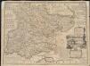
An accurate map of the county of Essex, divided into its hundreds
1 : 180000