Maps of Southwark

Plan for the improvement of the approaches on the south side of New London Bridge] Part B
1 : 960 A section at the base of the map shows the line of ascent of the new road from the centre of the first arch on the Surrey side of the river, and the high-water mark of the Thames at this point. Blue flags mark the lower ground level before the line of ascent to the bridge. Gwilt, George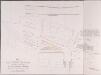
Plan for preventing the Traffic to the WHARFS AND PREMISES IN TOOLEY STREET being impeded by that proceeding TO THE FOUR RAILWAY STATIONS
This is a plan for improving the approaches to London Bridge Station, then the terminus for the Eastern, Brighton, Croydon and Greenwich railways. The plan is oriented to the south. It's title features at bottom left, with an explanatory note at middle right. The current approach to the station is highlighted in yellow with the proposed improvements outlined in red. Above the plan are level sections of the present and proposed approaches. Allen, George
Insurance Plan of City of London Vol. IV: sheet 80
1 : 480 This detailed 1887 plan of London is one of a series of twenty-three sheets in an atlas originally produced to aid insurance companies in assessing fire risks. The building footprints, their use (commercial, residential, educational, etc.), the number of floors and the height of the building, as well as construction materials (and thus risk of burning) and special fire hazards (chemicals, kilns, ovens) were documented in order to estimate premiums. Names of individual businesses, property lines, and addresses were also often recorded. Together these maps provide a rich historical shapshot of the commercial activity and urban landscape of towns and cities at the time. The British Library holds a comprehensive collection of fire insurance plans produced by the London-based firm Charles E. Goad Ltd. dating back to 1885. These plans were made for most important towns and cities of the British Isles at the scales of 1:480 (1 inch to 40 feet), as well as many foreign towns at 1:600 (1 inch to 50 feet). Chas E Goad Limited Chas E Goad Limited
Insurance Plan of City of London Vol. IV: sheet 79
1 : 480 This detailed 1887 plan of London is one of a series of twenty-three sheets in an atlas originally produced to aid insurance companies in assessing fire risks. The building footprints, their use (commercial, residential, educational, etc.), the number of floors and the height of the building, as well as construction materials (and thus risk of burning) and special fire hazards (chemicals, kilns, ovens) were documented in order to estimate premiums. Names of individual businesses, property lines, and addresses were also often recorded. Together these maps provide a rich historical shapshot of the commercial activity and urban landscape of towns and cities at the time. The British Library holds a comprehensive collection of fire insurance plans produced by the London-based firm Charles E. Goad Ltd. dating back to 1885. These plans were made for most important towns and cities of the British Isles at the scales of 1:480 (1 inch to 40 feet), as well as many foreign towns at 1:600 (1 inch to 50 feet). Chas E Goad Limited Chas E Goad Limited
Insurance Plan of City of London Vol. IV: sheet 91
1 : 480 This detailed 1887 plan of London is one of a series of twenty-three sheets in an atlas originally produced to aid insurance companies in assessing fire risks. The building footprints, their use (commercial, residential, educational, etc.), the number of floors and the height of the building, as well as construction materials (and thus risk of burning) and special fire hazards (chemicals, kilns, ovens) were documented in order to estimate premiums. Names of individual businesses, property lines, and addresses were also often recorded. Together these maps provide a rich historical shapshot of the commercial activity and urban landscape of towns and cities at the time. The British Library holds a comprehensive collection of fire insurance plans produced by the London-based firm Charles E. Goad Ltd. dating back to 1885. These plans were made for most important towns and cities of the British Isles at the scales of 1:480 (1 inch to 40 feet), as well as many foreign towns at 1:600 (1 inch to 50 feet). Chas E Goad Limited Chas E Goad Limited
Insurance Plan of London. Goad
London: Chas. E. Goad
Insurance Plan of City of London Vol. IV: sheet 76-1
1 : 480 This detailed 1887 plan of London is one of a series of twenty-three sheets in an atlas originally produced to aid insurance companies in assessing fire risks. The building footprints, their use (commercial, residential, educational, etc.), the number of floors and the height of the building, as well as construction materials (and thus risk of burning) and special fire hazards (chemicals, kilns, ovens) were documented in order to estimate premiums. Names of individual businesses, property lines, and addresses were also often recorded. Together these maps provide a rich historical shapshot of the commercial activity and urban landscape of towns and cities at the time. The British Library holds a comprehensive collection of fire insurance plans produced by the London-based firm Charles E. Goad Ltd. dating back to 1885. These plans were made for most important towns and cities of the British Isles at the scales of 1:480 (1 inch to 40 feet), as well as many foreign towns at 1:600 (1 inch to 50 feet). Chas E Goad Limited Chas E Goad Limited
Insurance Plan of City of London Vol. IV: sheet 78
1 : 480 This detailed 1887 plan of London is one of a series of twenty-three sheets in an atlas originally produced to aid insurance companies in assessing fire risks. The building footprints, their use (commercial, residential, educational, etc.), the number of floors and the height of the building, as well as construction materials (and thus risk of burning) and special fire hazards (chemicals, kilns, ovens) were documented in order to estimate premiums. Names of individual businesses, property lines, and addresses were also often recorded. Together these maps provide a rich historical shapshot of the commercial activity and urban landscape of towns and cities at the time. The British Library holds a comprehensive collection of fire insurance plans produced by the London-based firm Charles E. Goad Ltd. dating back to 1885. These plans were made for most important towns and cities of the British Isles at the scales of 1:480 (1 inch to 40 feet), as well as many foreign towns at 1:600 (1 inch to 50 feet). Chas E Goad Limited Chas E Goad Limited
Insurance Plan of City of London Vol. IV: Key Plan 1
1 : 480 This "key plan" indicates coverage of the Goad 1887 series of fire insurance maps of London that were originally produced to aid insurance companies in assessing fire risks. The building footprints, their use (commercial, residential, educational, etc.), the number of floors and the height of the building, as well as construction materials (and thus risk of burning) and special fire hazards (chemicals, kilns, ovens) were documented in order to estimate premiums. Names of individual businesses, property lines, and addresses were also often recorded. Together these maps provide a rich historical shapshot of the commercial activity and urban landscape of towns and cities at the time. The British Library holds a comprehensive collection of fire insurance plans produced by the London-based firm Charles E. Goad Ltd. dating back to 1885. These plans were made for most important towns and cities of the British Isles at the scales of 1:480 (1 inch to 40 feet), as well as many foreign towns at 1:600 (1 inch to 50 feet). Chas E Goad Limited Chas E Goad Limited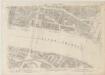
London VII.76 - OS London Town Plan
1 : 1056 Topographic maps Ordnance Survey Ordnance Survey
Insurance Plan of City of London Vol. IV: sheet 92
1 : 480 This detailed 1887 plan of London is one of a series of twenty-three sheets in an atlas originally produced to aid insurance companies in assessing fire risks. The building footprints, their use (commercial, residential, educational, etc.), the number of floors and the height of the building, as well as construction materials (and thus risk of burning) and special fire hazards (chemicals, kilns, ovens) were documented in order to estimate premiums. Names of individual businesses, property lines, and addresses were also often recorded. Together these maps provide a rich historical shapshot of the commercial activity and urban landscape of towns and cities at the time. The British Library holds a comprehensive collection of fire insurance plans produced by the London-based firm Charles E. Goad Ltd. dating back to 1885. These plans were made for most important towns and cities of the British Isles at the scales of 1:480 (1 inch to 40 feet), as well as many foreign towns at 1:600 (1 inch to 50 feet). Chas E Goad Limited Chas E Goad Limited
Insurance Plan of City of London Vol. IV: sheet 81
1 : 480 This detailed 1887 plan of London is one of a series of twenty-three sheets in an atlas originally produced to aid insurance companies in assessing fire risks. The building footprints, their use (commercial, residential, educational, etc.), the number of floors and the height of the building, as well as construction materials (and thus risk of burning) and special fire hazards (chemicals, kilns, ovens) were documented in order to estimate premiums. Names of individual businesses, property lines, and addresses were also often recorded. Together these maps provide a rich historical shapshot of the commercial activity and urban landscape of towns and cities at the time. The British Library holds a comprehensive collection of fire insurance plans produced by the London-based firm Charles E. Goad Ltd. dating back to 1885. These plans were made for most important towns and cities of the British Isles at the scales of 1:480 (1 inch to 40 feet), as well as many foreign towns at 1:600 (1 inch to 50 feet). Chas E Goad Limited Chas E Goad Limited
Insurance Plan of City of London Vol. IV: sheet 75
1 : 480 This detailed 1887 plan of London is one of a series of twenty-three sheets in an atlas originally produced to aid insurance companies in assessing fire risks. The building footprints, their use (commercial, residential, educational, etc.), the number of floors and the height of the building, as well as construction materials (and thus risk of burning) and special fire hazards (chemicals, kilns, ovens) were documented in order to estimate premiums. Names of individual businesses, property lines, and addresses were also often recorded. Together these maps provide a rich historical shapshot of the commercial activity and urban landscape of towns and cities at the time. The British Library holds a comprehensive collection of fire insurance plans produced by the London-based firm Charles E. Goad Ltd. dating back to 1885. These plans were made for most important towns and cities of the British Isles at the scales of 1:480 (1 inch to 40 feet), as well as many foreign towns at 1:600 (1 inch to 50 feet). Chas E Goad Limited Chas E Goad Limited
PLAN OF THE STREETS, ROADS &c. BETWEEN LAMBETH AND SOUTHWARK
1 : 5280 This is a plan of Saint George's Fields, between Lambeth and Southwark, with the title and scale bar in a table at bottom right and compass rose at bottom centre. The plan shows the proposals for Blackfriars Road and the southern approaches to Blackfriars Bridge as finally laid out during the period 1770-1800. Kitchin, Thomas
A Plan of the Streets, Roads &c. Between Black Fryers Bridge &c.
The title of this plan of Saint George's Fields, Southwark, appears in a table at bottom right, with a compass star at bottom centre, scale bar at top right, and an inset view of Blackfriars Bridge along the right margin. The plan shows the proposals for Blackfriars Road and the southern approaches to Blackfriars Bridge as they were finally laid during the last quarter of the 18th Century. Kitchin, Thomas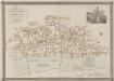
GENERAL PLAN OF THAT PART OF THE CITY OF LONDON THAT WAS DESTROYED BY THE GREAT FIRE OF 1666; SHOWING THE PRESENT STATE THEREOF
1 : 2431 This retrospective map compares pre-fire London with the city of the 1830s. The title and publisher's imprint appear at top left, with a reference table at bottom right, scale bar at bottom centre, and woodcut view of the Temple at top right. The map shows churches, halls and public buildings destroyed in the fire in grey,with contemporary buildings in pink. Wishaw, Francis
Plan of the Cities of London and Westminster, the Borough of Southwark and parts adjoining, shewing every house. By R. Horwood. [Scale, about 25 inches = 1 mile]
Horwood, Richard
London (1915- Numbered sheets) V.15 (includes: Bermondsey; London; Stepney) - 25 Inch Map
1 : 2500 Topographic maps Ordnance Survey Ordnance Survey
London (Edition of 1894-96) LXXVII (includes: Bermondsey; London; Stepney) - 25 Inch Map
1 : 2500 Topographic maps Ordnance Survey Ordnance Survey
London (First Editions c1850s) XLV (includes: Bermondsey; London; Stepney) - 25 Inch Map
1 : 2500 Topographic maps Ordnance Survey Ordnance Survey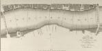
A SURVEY of the RIVER THAMES between London Bridge and Blackfriars Bridge with the SOUNDINGS within those Limits
1 : 2664 The title of this plan appears at bottom right, with compass star and scale bar at bottom centre. Produced by the Surveying Office at Guildhall, the plan was intended as an aid for navigation along the Thames and indicates the location of all stairs to the river and water soundings at various points along the course. Surveying Office, Guildhall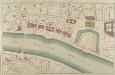
PART of LONDON shewing the IMPROVEMENTS propos'd about LONDON-BRIDGE, the CUSTOM HOUSE, TOWER &c.
The proposed renovations of this new plan are superimposed on the layout of the old. Red lines show new streets in a grid-like formation replacing the older, narrower streets and buildings. A red line across the front of the Tower of London complex possibly indicates a new wall. Gwynn, John
A PLAN for A STREET Eighty Feet wide, and Fifty Feet deep, on each side, between the ROYAL EXCHANGE AND LONDON BRIDGE
1 : 7200 This is a plan for a new street connecting the Royal Exchange to London Bridge. The different colours used on this plan denote the property of the different wards of Cornhill, Langbourn, Candlewick and Bridge. In the top left corner is a manuscript note about the ''peers'' (supporting piers) of Southwark Bridge. Luffman, John
London VII.86 - OS London Town Plan
1 : 1056 Topographic maps Ordnance Survey Ordnance Survey
London VII.75 - OS London Town Plan
1 : 1056 Topographic maps Ordnance Survey Ordnance Survey
London VII.85 - OS London Town Plan
1 : 1056 Topographic maps Ordnance Survey Ordnance Survey
BILLINSGATE WARD AND BRIDGE WARD WITHIN with their Divisions into PARISHES According to a new SURVEY
1 : 1800 This plan was published in William Maitland's 'History of London from its Foundation to the Present Time'. The plan's title features in cartouche at bottom left, with the arms of William Beckford, Alderman of Billinsgate, and William Stephenson, Aldermen of Bridge Ward, down the left side of the plate. The compass star and scale bar are at top centre. At top left and bottom right are illustrated views of the churches of St Mary and St. Botolph. Engraved by Cole, Maitand's ward plans were largely derived from Strype's plans, with the illustrations copied from West Tow's 'Prospect Views of Ancient Churches' of 1736. Cole, B.
Insurance Plan of City of London Vol. IV: sheet 94-1
1 : 480 This detailed 1887 plan of London is one of a series of twenty-three sheets in an atlas originally produced to aid insurance companies in assessing fire risks. The building footprints, their use (commercial, residential, educational, etc.), the number of floors and the height of the building, as well as construction materials (and thus risk of burning) and special fire hazards (chemicals, kilns, ovens) were documented in order to estimate premiums. Names of individual businesses, property lines, and addresses were also often recorded. Together these maps provide a rich historical shapshot of the commercial activity and urban landscape of towns and cities at the time. The British Library holds a comprehensive collection of fire insurance plans produced by the London-based firm Charles E. Goad Ltd. dating back to 1885. These plans were made for most important towns and cities of the British Isles at the scales of 1:480 (1 inch to 40 feet), as well as many foreign towns at 1:600 (1 inch to 50 feet). Chas E Goad Limited Chas E Goad Limited
BILLINSGATE and BRIDGE WARD Within with its Division into Parishes taken from the last Survey. 6a
1 : 2400 This map is taken from Strype's first annotated edition of Stow's 'Survey of England'. The map's title appears in ornamental cartouche at top centre, with a key to streets, yards, halls, courts and private properties in a table below the title. The plan also features compass star at bottom left and scale bar at bottom right. Prominent buildings and ships sailing along the Thames are represented pictorially. Blome, Richard
![Plan for the improvement of the approaches on the south side of New London Bridge] Part B](https://images-2.georeferencer.com/images/iiif/183336388559/full/,300/0/native.jpg)

