Maps of Islington

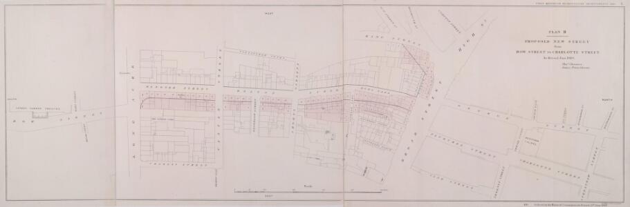
PLAN B. PROPOSED NEW STREET from BOW STREET TO CHARLOTTE STREET. As Revised June 1840
1 : 648 This plan was commissioned by the House of Parliament and shows the proposed new street from Long Acre to Broad Street in the parish of St Giles's, London. Day & Hague
Insurance Plan of London Vol. VIII: sheet 195
1 : 480 This detailed 1888 plan of London is one of a series of twenty-six sheets in an atlas originally produced to aid insurance companies in assessing fire risks. The building footprints, their use (commercial, residential, educational, etc.), the number of floors and the height of the building, as well as construction materials (and thus risk of burning) and special fire hazards (chemicals, kilns, ovens) were documented in order to estimate premiums. Names of individual businesses, property lines, and addresses were also often recorded. Together these maps provide a rich historical shapshot of the commercial activity and urban landscape of towns and cities at the time. The British Library holds a comprehensive collection of fire insurance plans produced by the London-based firm Charles E. Goad Ltd. dating back to 1885. These plans were made for most important towns and cities of the British Isles at the scales of 1:480 (1 inch to 40 feet), as well as many foreign towns at 1:600 (1 inch to 50 feet). Chas E Goad Limited Chas E Goad Limited
Insurance Plan of London Vol. VIII: sheet 194
1 : 480 This detailed 1888 plan of London is one of a series of twenty-six sheets in an atlas originally produced to aid insurance companies in assessing fire risks. The building footprints, their use (commercial, residential, educational, etc.), the number of floors and the height of the building, as well as construction materials (and thus risk of burning) and special fire hazards (chemicals, kilns, ovens) were documented in order to estimate premiums. Names of individual businesses, property lines, and addresses were also often recorded. Together these maps provide a rich historical shapshot of the commercial activity and urban landscape of towns and cities at the time. The British Library holds a comprehensive collection of fire insurance plans produced by the London-based firm Charles E. Goad Ltd. dating back to 1885. These plans were made for most important towns and cities of the British Isles at the scales of 1:480 (1 inch to 40 feet), as well as many foreign towns at 1:600 (1 inch to 50 feet). Chas E Goad Limited Chas E Goad Limited
Insurance Plan of London Vol. VIII: sheet 200
1 : 480 This detailed 1888 plan of London is one of a series of twenty-six sheets in an atlas originally produced to aid insurance companies in assessing fire risks. The building footprints, their use (commercial, residential, educational, etc.), the number of floors and the height of the building, as well as construction materials (and thus risk of burning) and special fire hazards (chemicals, kilns, ovens) were documented in order to estimate premiums. Names of individual businesses, property lines, and addresses were also often recorded. Together these maps provide a rich historical shapshot of the commercial activity and urban landscape of towns and cities at the time. The British Library holds a comprehensive collection of fire insurance plans produced by the London-based firm Charles E. Goad Ltd. dating back to 1885. These plans were made for most important towns and cities of the British Isles at the scales of 1:480 (1 inch to 40 feet), as well as many foreign towns at 1:600 (1 inch to 50 feet). Chas E Goad Limited Chas E Goad Limited
Insurance Plan of London Vol. VIII: sheet 196
1 : 480 This detailed 1888 plan of London is one of a series of twenty-six sheets in an atlas originally produced to aid insurance companies in assessing fire risks. The building footprints, their use (commercial, residential, educational, etc.), the number of floors and the height of the building, as well as construction materials (and thus risk of burning) and special fire hazards (chemicals, kilns, ovens) were documented in order to estimate premiums. Names of individual businesses, property lines, and addresses were also often recorded. Together these maps provide a rich historical shapshot of the commercial activity and urban landscape of towns and cities at the time. The British Library holds a comprehensive collection of fire insurance plans produced by the London-based firm Charles E. Goad Ltd. dating back to 1885. These plans were made for most important towns and cities of the British Isles at the scales of 1:480 (1 inch to 40 feet), as well as many foreign towns at 1:600 (1 inch to 50 feet). Chas E Goad Limited Chas E Goad Limited
Insurance Plan of London Vol. VIII: sheet 197
1 : 480 This detailed 1888 plan of London is one of a series of twenty-six sheets in an atlas originally produced to aid insurance companies in assessing fire risks. The building footprints, their use (commercial, residential, educational, etc.), the number of floors and the height of the building, as well as construction materials (and thus risk of burning) and special fire hazards (chemicals, kilns, ovens) were documented in order to estimate premiums. Names of individual businesses, property lines, and addresses were also often recorded. Together these maps provide a rich historical shapshot of the commercial activity and urban landscape of towns and cities at the time. The British Library holds a comprehensive collection of fire insurance plans produced by the London-based firm Charles E. Goad Ltd. dating back to 1885. These plans were made for most important towns and cities of the British Isles at the scales of 1:480 (1 inch to 40 feet), as well as many foreign towns at 1:600 (1 inch to 50 feet). Chas E Goad Limited Chas E Goad Limited
Plan of property comprising individual houses at in Holborn
This is a house by house plan of the land off the Holborn Road. The dimensions of each house and the name of the person who lives there is recorded. The survey was carried out by Thomas Chawner who, along with James Pennethorne, produced the plans for the proposal for the new street between Oxford Street and Holborn. Chawner, Thomas
Insurance Plan of London Vol. VIII: sheet 190
1 : 480 This detailed 1888 plan of London is one of a series of twenty-six sheets in an atlas originally produced to aid insurance companies in assessing fire risks. The building footprints, their use (commercial, residential, educational, etc.), the number of floors and the height of the building, as well as construction materials (and thus risk of burning) and special fire hazards (chemicals, kilns, ovens) were documented in order to estimate premiums. Names of individual businesses, property lines, and addresses were also often recorded. Together these maps provide a rich historical shapshot of the commercial activity and urban landscape of towns and cities at the time. The British Library holds a comprehensive collection of fire insurance plans produced by the London-based firm Charles E. Goad Ltd. dating back to 1885. These plans were made for most important towns and cities of the British Isles at the scales of 1:480 (1 inch to 40 feet), as well as many foreign towns at 1:600 (1 inch to 50 feet). Chas E Goad Limited Chas E Goad Limited
Plan of Houses & Ground in and near Holbourn, held by Thomas Lee Esq: under lease by the Crown
Drawn plan of the property near Holborn leased by the Crown to Thomas Lee.
GROUND PLAN of an ESTATE Situate at Seven Dials in the Parish of ST.GILES in the FIELDS, Surveyed 1811 by H. LANE, 1 London Street, Fitzroy Square
1 : 300 This plan covers the area of the Seven Dials, a street formation of seven streets radiating from a central point. Thomas Neale, Master of the Mint began the development of the complex in 1693. The project was completed around 1710. In 1694 John Evelyn went to see the building work and commented on the star formation radiating from a point marked by a Doric pillar. This pillar was removed in 1773 as it had become a meeting place for criminals, partly due to a false rumour that a large sum of money had been buried at its base. Although intended as a smart residential area, it became the haunt of thieves and street vendors in the 18th and 19th centuries. The building of Shaftsbury Avenue and Charing Cross Road reduced the area to little more than a junction. Hewitt
London VII.63 - OS London Town Plan
1 : 1056 Topographic maps Ordnance Survey Ordnance Survey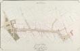
General Plan, shewing the whole line of the Proposed New Street to the British Museum
1 : 4800 A plan of the proposed street running to the British Museum in Bloomsbury. Ingrey & Madeley's
A Plan of the intended improvements from Charing Cross to Bedford Square
A plan of intended improvements from Charing Cross to Bedford Square. Sawyer, Henry
A Map of the PARISH of ST. PAUL COVENT GARDEN, Shewing the site of BEDFORD HOUSE & GROUNDS. From a Survey, made by WILLIAM LYBORN, in the Year 1686.
1 : 960 A pecked line marks the parish boundary of St Paul's, Covent Carden. Covent Garden was the metropolitan estate of the Russell family: the earls and dukes of Bedford. Bedford House, built in 1586 for the third earl of Bedford, appears to have been an important boundary marker. The development of the area in the 1630s saw it become the first suburb outside the City to be financed by the leasehold system and regulated by building covenants. These factors, combined with Inigo Jones' architecture, made Covent Garden a prototype which was aspired to for the next 250 years. Lyborn, William
A MAPP of the Parish of St PAULS COVENT GARDEN taken from the last Survey By Blome, Richard
Richard Blome was the acting editor of Stow's Survey at this time. Pecked lines show parish boundaries. Bedford House and garden appear on this map. Built in 1586 to replace the Earls of Bedford's earlier mansion on the south side of the Strand, it was demolished in 1706, making way for Southampton Street, Tavistock Street and Tavistock Row. Covent Garden was the metropolitan estate of the Earls and Dukes of Bedford, whose family name was Russell. They later came to own much of Bloomsbury, hence the name of Russell Square. Blome, Richard
A Plan of the Parish of St Paul's Covent Garden
This is a 19th-Century copy of a map from the beginning of the previous century. It shows Old Bedford House in the Strand. Individual houses around the piazza in Covent Garden are numbered. The New Exchange is marked on the Strand. This was a very smart shopping arcade completed in 1609, taking over much of the trade of the Royal Exchange after it was destroyed in the Great Fire. Historian and biographer John Strype described it in 1720 as ''a place of great resort and trade for the nobility and gentry.''
Insurance Plan of London Vol. VIII: sheet 191
1 : 480 This detailed 1888 plan of London is one of a series of twenty-six sheets in an atlas originally produced to aid insurance companies in assessing fire risks. The building footprints, their use (commercial, residential, educational, etc.), the number of floors and the height of the building, as well as construction materials (and thus risk of burning) and special fire hazards (chemicals, kilns, ovens) were documented in order to estimate premiums. Names of individual businesses, property lines, and addresses were also often recorded. Together these maps provide a rich historical shapshot of the commercial activity and urban landscape of towns and cities at the time. The British Library holds a comprehensive collection of fire insurance plans produced by the London-based firm Charles E. Goad Ltd. dating back to 1885. These plans were made for most important towns and cities of the British Isles at the scales of 1:480 (1 inch to 40 feet), as well as many foreign towns at 1:600 (1 inch to 50 feet). Chas E Goad Limited Chas E Goad Limited
Insurance Plan of London Vol. VIII: sheet 189
1 : 480 This detailed 1888 plan of London is one of a series of twenty-six sheets in an atlas originally produced to aid insurance companies in assessing fire risks. The building footprints, their use (commercial, residential, educational, etc.), the number of floors and the height of the building, as well as construction materials (and thus risk of burning) and special fire hazards (chemicals, kilns, ovens) were documented in order to estimate premiums. Names of individual businesses, property lines, and addresses were also often recorded. Together these maps provide a rich historical shapshot of the commercial activity and urban landscape of towns and cities at the time. The British Library holds a comprehensive collection of fire insurance plans produced by the London-based firm Charles E. Goad Ltd. dating back to 1885. These plans were made for most important towns and cities of the British Isles at the scales of 1:480 (1 inch to 40 feet), as well as many foreign towns at 1:600 (1 inch to 50 feet). Chas E Goad Limited Chas E Goad Limited
Insurance Plan of London Vol. VIII: sheet 198
1 : 480 This detailed 1888 plan of London is one of a series of twenty-six sheets in an atlas originally produced to aid insurance companies in assessing fire risks. The building footprints, their use (commercial, residential, educational, etc.), the number of floors and the height of the building, as well as construction materials (and thus risk of burning) and special fire hazards (chemicals, kilns, ovens) were documented in order to estimate premiums. Names of individual businesses, property lines, and addresses were also often recorded. Together these maps provide a rich historical shapshot of the commercial activity and urban landscape of towns and cities at the time. The British Library holds a comprehensive collection of fire insurance plans produced by the London-based firm Charles E. Goad Ltd. dating back to 1885. These plans were made for most important towns and cities of the British Isles at the scales of 1:480 (1 inch to 40 feet), as well as many foreign towns at 1:600 (1 inch to 50 feet). Chas E Goad Limited Chas E Goad Limited
PLAN OF BEDFORD HOUSE, COVENT GARDEN, &c. TAKEN ABOUT 1690
This map is copied from a 1690 drawing in Crowle's Pennant, held in the British Museum. Annotations appear across the drawing, recording local history before and after 1690. For example, in St Paul's churchyard is mentioned Marmaduke Conway, who died in 1717 at the age of 108 having never lost a single tooth. It also shows the location of Bedford House, which had been taken down over a century earlier. Around the border of the map are more informative gems, such as the location of a house named ''Two Golden Balls'' which in 1711 was famous for magical entertainments. Smith, John Thomas
Insurance Plan of London Vol. IX: sheet 226
1 : 480 This detailed 1889 plan of London is one of a series of twenty-seven sheets in an atlas originally produced to aid insurance companies in assessing fire risks. The building footprints, their use (commercial, residential, educational, etc.), the number of floors and the height of the building, as well as construction materials (and thus risk of burning) and special fire hazards (chemicals, kilns, ovens) were documented in order to estimate premiums. Names of individual businesses, property lines, and addresses were also often recorded. Together these maps provide a rich historical shapshot of the commercial activity and urban landscape of towns and cities at the time. The British Library holds a comprehensive collection of fire insurance plans produced by the London-based firm Charles E. Goad Ltd. dating back to 1885. These plans were made for most important towns and cities of the British Isles at the scales of 1:480 (1 inch to 40 feet), as well as many foreign towns at 1:600 (1 inch to 50 feet). Chas E Goad Limited Chas E Goad Limited
Insurance Plan of London Vol. VIII: sheet 202
1 : 480 This detailed 1888 plan of London is one of a series of twenty-six sheets in an atlas originally produced to aid insurance companies in assessing fire risks. The building footprints, their use (commercial, residential, educational, etc.), the number of floors and the height of the building, as well as construction materials (and thus risk of burning) and special fire hazards (chemicals, kilns, ovens) were documented in order to estimate premiums. Names of individual businesses, property lines, and addresses were also often recorded. Together these maps provide a rich historical shapshot of the commercial activity and urban landscape of towns and cities at the time. The British Library holds a comprehensive collection of fire insurance plans produced by the London-based firm Charles E. Goad Ltd. dating back to 1885. These plans were made for most important towns and cities of the British Isles at the scales of 1:480 (1 inch to 40 feet), as well as many foreign towns at 1:600 (1 inch to 50 feet). Chas E Goad Limited Chas E Goad Limited
Insurance Plan of London Vol. VIII: sheet 193
1 : 480 This detailed 1888 plan of London is one of a series of twenty-six sheets in an atlas originally produced to aid insurance companies in assessing fire risks. The building footprints, their use (commercial, residential, educational, etc.), the number of floors and the height of the building, as well as construction materials (and thus risk of burning) and special fire hazards (chemicals, kilns, ovens) were documented in order to estimate premiums. Names of individual businesses, property lines, and addresses were also often recorded. Together these maps provide a rich historical shapshot of the commercial activity and urban landscape of towns and cities at the time. The British Library holds a comprehensive collection of fire insurance plans produced by the London-based firm Charles E. Goad Ltd. dating back to 1885. These plans were made for most important towns and cities of the British Isles at the scales of 1:480 (1 inch to 40 feet), as well as many foreign towns at 1:600 (1 inch to 50 feet). Chas E Goad Limited Chas E Goad Limited
A MAPP of the PARISH of ST GILES'S in the Fields taken from the last Servey, with Corrections and Additions 1-A
1 : 2748 Plan of the parish of St Giles's from the 1720 edition of Stowe's Survey of England. The plan features title in banner at top left, reference table down the right side of the plate, with compass and scale bar at bottom left. The boundaries of the parish are indicated by a pecked line. Blome, Richard
To the Most Noble JOHN, DUKE OF BEDFORD. This Plan of the United Parishes of ST. GILES in the FIELDS & ST. GEORGE, BLOOMSBURY, 4
1 : 444 This map is dedicated to the Duke of Bedford as this area was the primary metropolitan estate of the Earls ans Dukes of Bedford. Russell was the family name of the Dukes of Bedford, hence Russell Square. Bedford house, built for the 3rd Earl of Bedford in 1586, lay adjacent to Montague house, later to be the British Museum, until 1705-6 when it was demolished. In the lower left hand corner is a vignette of a statue of a Duke of Bedford. A birds eye view of the British Museum and a view of the College of Surgeons are also included as is a statue of C.J Fox right hon, the orator. Wyld, James
Plan OF THE PARISHES OR DIVISION OF St Giles in the Fields And ST. GEORGE, BLOOMSBURY. 1815 2
1 : 2400 Different pastel colours describe the Parish divisions within St. Giles in the Fields and St. George's, Bloomsbury. A plan of the Burial Ground and Chapel of St. Giles in the Field, adjoining the church yard of St Pancreas, is located in a separate border. Montagu House was sold in 1755 to house the British museum. It was demolished to make way for Smirke''s building in the 1840''s. Hewitt, N.R.
Insurance Plan of London Vol. VIII: Key Plan
1 : 480 This "key plan" indicates coverage of the Goad 1888 series of fire insurance maps of London that were originally produced to aid insurance companies in assessing fire risks. The building footprints, their use (commercial, residential, educational, etc.), the number of floors and the height of the building, as well as construction materials (and thus risk of burning) and special fire hazards (chemicals, kilns, ovens) were documented in order to estimate premiums. Names of individual businesses, property lines, and addresses were also often recorded. Together these maps provide a rich historical shapshot of the commercial activity and urban landscape of towns and cities at the time. The British Library holds a comprehensive collection of fire insurance plans produced by the London-based firm Charles E. Goad Ltd. dating back to 1885. These plans were made for most important towns and cities of the British Isles at the scales of 1:480 (1 inch to 40 feet), as well as many foreign towns at 1:600 (1 inch to 50 feet). Chas E Goad Limited Chas E Goad Limited
Collins' Illustrated Atlas of London with 7000 references, in 36 plates of the principal routes between St. Paul's and the suburbs, from a survey made expressly for this work, by R. Jarman
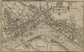
WESTMINSTER
This plan-view of Westminster was published in Norden's 'Speculum Britanniae' in 1593. The title appears at top right below the royal arms, with a compass rose at the foot of the plate. Under different jurisdiction than the City of London, Westminster had developed during the middle ages into a centre of royal administration. Along the Strand are the former residences of the Bishops deposed at the Reformation. By the late 16th Century, these properties were in the hands of the Queen's courtiers, statesmen and other people of influence. Norden, John