Maps of Camden
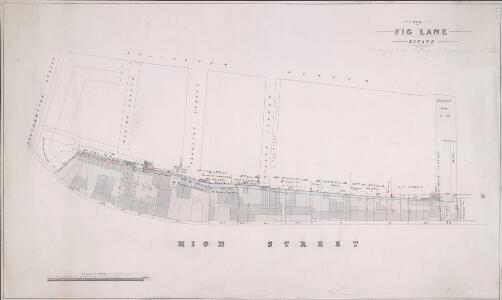
THE FIG LANE ESTATE
1 : 480 This plan of a Camden Town estate features title at top right and scale bar at bottom left. The plan shows the properties in the Fig Lane Estate in grey with the sewage canal running behind them in blue. Salway, T.
London VII.22 - OS London Town Plan
1 : 1056 Topographic maps Ordnance Survey Ordnance Survey
Insurance Plan of London Vol. xi: sheet 372-2
1 : 480 This detailed 1891 plan of London is one of a series of forty seven sheets in an atlas originally produced to aid insurance companies in assessing fire risks. The building footprints, their use (commercial, residential, educational, etc.), the number of floors and the height of the building, as well as construction materials (and thus risk of burning) and special fire hazards (chemicals, kilns, ovens) were documented in order to estimate premiums. Names of individual businesses, property lines, and addresses were also often recorded. Together these maps provide a rich historical shapshot of the commercial activity and urban landscape of towns and cities at the time. The British Library holds a comprehensive collection of fire insurance plans produced by the London-based firm Charles E. Goad Ltd. dating back to 1885. These plans were made for most important towns and cities of the British Isles at the scales of 1:480 (1 inch to 40 feet), as well as many foreign towns at 1:600 (1 inch to 50 feet). Chas E Goad Limited Chas E Goad Limited
Some account of the proposed improvements of the Western part of London, by the formation of the Regent's Park, the new street, the new sewer. ... Illustrated by plans and accompanied by critical observations.

THE REGENT'S PARK
1 : 4800 This plan was commissioned by the House of Commons and issued as a supplement to the Wood, Forests and Land Revenues report. The plan's title and imprint are at top right, with a scale bar and key at bottom right. The part of the park to be opened to the public is shown in pale yellow. The grounds of the Zoological Society and the Royal Botanic Society are shown in pink. The areas to be fenced off to protect the privacy of the local residents are shown in dark green. The land to the north of the park recently acquired by Eton College is shown in pale green, and that acquired by Lord Southampton, in pink. Basire, James
London VII.NW - OS Six-Inch Map
1 : 10560 Topographic maps Ordnance Survey Ordnance Survey
PLAN of the several Freehold Estates situated on the North side of the New Road within the Parish of St. Mary-le-bone and Parts of Hampstead and St. Pancras in the County of Middlesex
1 : 1584 This is Crace's own copy of an 18th-Century plan of the estates north of the New Road at Marylebone. The title and scale bar feature at bottom left, with compass at top centre, and descriptive notes at top left and down the right margin of the sheet. Outline colour marks the boundaries of estates and a single black line those of fields within the estate. The plan also reports the names of landlords and tenant occupiers, with key to the dimensions of each field and estate in a table above the plan. Jones, John
A Plan of the New Intended Road from Paddington to Islington.

A Plan of te Parish of ST MARY ISLINGTON, with the boundaries of the Several Ecclesiastical Districts, Sueveyed by R. Creighton for the Parochial History, BY S. LEWIS, JUNR.
1 : 15840 Plan of the parish of St Mary's Islington, with the nine ecclesiastical districts that make up the parish delineated by pastel colours. Dower, John, Pentonville.
Charles Booth's descriptive map of London poverty 1889
Charles Booth
PLAN OF THE PARISH OF ST. MARYLEBONE with the Improvements proposed ON THE MARYLEBONE PARK ESTATE WITH THE CONTIGUOUS PARTS of the Parish of St. Pancras
1 : 5333 Plan of the Parish of St. Marylebone with title at bottom left and explanatory note at bottom right describing proposals for building houses and gardens on land belonging to the Crown along the New Road. White, John
Insurance Plan of London North District Vol. D: Key Plan
1 : 3600 This "key plan" indicates coverage of the Goad 1901 series of fire insurance maps of London that were originally produced to aid insurance companies in assessing fire risks. The building footprints, their use (commercial, residential, educational, etc.), the number of floors and the height of the building, as well as construction materials (and thus risk of burning) and special fire hazards (chemicals, kilns, ovens) were documented in order to estimate premiums. Names of individual businesses, property lines, and addresses were also often recorded. Together these maps provide a rich historical shapshot of the commercial activity and urban landscape of towns and cities at the time. The British Library holds a comprehensive collection of fire insurance plans produced by the London-based firm Charles E. Goad Ltd. dating back to 1885. These plans were made for most important towns and cities of the British Isles at the scales of 1:480 (1 inch to 40 feet), as well as many foreign towns at 1:600 (1 inch to 50 feet). Chas E Goad Limited Chas E Goad Limited
London NW.
1 : 15840 Stanford, Edward
PLAN OF ISLINGTON PARISH
1 : 9744 This detailed plan of the parish of Islington records each property and field boundary and even indicates the layout of the gardens and trees. A vignette in the lower right corner shows a view of Canonbury from 1821. The note at lower left reports the increase in building over the last seven years and the population growth. Dent, R.
PLAN of the Parish of St. Mary. Islington
This is a plan of the parish of St Mary's, Islington, with three vignettes depicting the Scotch Church, the New Church and St Peter's Chapel down the right of the plate. Baker, B.
Insurance Plan of London North North West District Vol. D: Key Plan
1 : 10560 This "key plan" indicates coverage of the Goad 1892 series of fire insurance maps of London that were originally produced to aid insurance companies in assessing fire risks. The building footprints, their use (commercial, residential, educational, etc.), the number of floors and the height of the building, as well as construction materials (and thus risk of burning) and special fire hazards (chemicals, kilns, ovens) were documented in order to estimate premiums. Names of individual businesses, property lines, and addresses were also often recorded. Together these maps provide a rich historical shapshot of the commercial activity and urban landscape of towns and cities at the time. The British Library holds a comprehensive collection of fire insurance plans produced by the London-based firm Charles E. Goad Ltd. dating back to 1885. These plans were made for most important towns and cities of the British Isles at the scales of 1:480 (1 inch to 40 feet), as well as many foreign towns at 1:600 (1 inch to 50 feet). Chas E Goad Limited Chas E Goad Limited
A NEW and CORRECT PLAN of the CITIES of LONDON, WESTMINSTER, and BOROUGH of SOUTHWARK wherein all the Streets, Roads, Churches, Public Buildings &c. to the Present Year 1775 are exactly Delineated
The title of this map runs along the top of the plan. The city boundaries are outlined in yellow, with a key to public buildings in London and Westminster in a table at top left. A list of parishes in Middlesex and Surrey features at top right, alongside a list of city wards and prominent London buildings. An inventory of churches in the City of London appears at bottom left and bottom right. The map shows the proposed new bridge and approaches at Blackfriars and all the proposed roads across St. George's Fields in Southwark, though not as finally laid out. Kitchin, Thomas
A NEW and CORRECT PLAN of the CITIES of LONDON, WESTMINSTER, and BOROUGH of SOUTHWARK wherein all the Streets, Roads, Churches, Public Buildings &c. To the Present Year 1785 are exactly delineated
Map publisher and print seller Robert Sayer traded from Fleet Street in the latter half of the 18th Century, first under his own name, and then under the joint imprint of Sayer& Bennett. This is a later edition of Sayer& Bennett's 1781 map of London. Coloured outlines appear along the boundaries of the London Wall, Westminster and Southwark. References tables appear in all four corners, listing public buildings, churches and the parishes within the Bills of Mortality (those parishes who reported deaths to the central London government). Open land, such as parks and gardens, is highlighted in green. R. Sayer & J. Bennett
A NEW and CORRECT PLAN of the CITIES of LONDON, WESTMINSTER, and BOROUGH of SOUTHWARK wherein all the Streets, Roads, Churches, Public Buildings &c. To the Present Year 1781 are exactly delineated
A table of references in the top-left corner identifies the Great Offices of State and public buildings. Different colours denote the boundaries of Westminster, Southwark and the City. Sayer, Robert and Bennett, John
This Actuall Survey Of LONDON, WESTMINSTER AND SOUTHWARK Is humbly Dedicated To Y.e L.d M.Yor & Court Of Aldermen by R.o: Morden, Phil: Lea Chr: Browne
This is a later edition of a very popular map of London first published by Morden and Lea in 1690. The map's title features along the top, with the city arms at top left, facing the publisher's imprint in shield at top right. The reference tables, scale bar and compass rose appear at lower right. The plan marks the city's growth in the late Stuart period, showing its northward spread towards Islington. Morden, Robert & Lea, Philip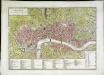
Londres (avec le bourg de Southwark)
1 Plan : Kupferdruck ; 26 x 45 cm, Bildgrösse 32 x 45 cm Mentelle; Tardieu; Dubuisson Mentelle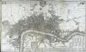
This actual survey of London Westminster Soutwark is humbly dedicated to y.e L.d Mayor [and] court of Aldermen
1 Plan auf 2 Blättern : Kupferdruck ; 58 x 98 cm chez Iean Cóvens et Corneille Mortier libraires et marchands des cartes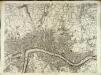
[A plan of London]
1 Plan : Kupferdruck ; 49 x 66 cm Rocque; Parr John Rocque
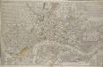
A NEW and CORRECT PLAN of the CITIES of LONDON, WESTMINSTER, and BOROUGH of SOUTHWARK wherein all the Streets, Roads, Churches, Public Buildings &c. to the Present Year 1791 are exactly delineated.
Map publisher and print seller Robert Sayer traded from Fleet Street in the latter half of the 18th century, first under his own name, and then under the joint imprint of Sayer& Bennett. This map has four-colour text panels in corners, including information relating to the recent Act for regulating Hackney Coaches. The development of turnpike roads in 1750 saw an increase of wheeled traffic, supplanting rivers as the main medium of transport. The map also features information about new rates for watermen introduced in 1785.The title of the plan states that it has been published as the "Act Directs”, a reference to the Copyright Act of 1734, used to curb the high incidence of uncredited copying among mapmakers. Sayer, Robert
A Survey of the Roads and Foot-paths in the Parish of ISLINGTON. From a plan in the Vestry Room, Drawn in the Year 1735
1 : 14400 This is a plan of footpaths and roads in the parish of Islington. It extends from Battle Bridge to Highgate and from ''Cruch End'' to Kings Land and the boundary to Shoreditch. An interesting feature on this map is Jack Straws House near Highbury. Jack Straw was a leader of one band of rebels who attacked the Treasurer's House at Highbury on June 14, 1381. The Peasants' Revolt over increasing taxation was largely due to the monarchy's prosectution of war against France. Toll gates are also marked in various places. Hawsworth, J.
HARRIS'S PLAN of LONDON, WESTMINSTER and the BOROUGH of SOUTHWARK, with all the additional Streets, Squares &c; also the improved ROADS to the Year 1794.
This map is the seventh edition of an original plan of1779. Differences between the fifth and sixth edition five suggest that the plate was re-engraved, at least in parts, as additional buildings appear in the sixth edition, dating from 1791.This edition claims to show London as it was in 1794, although no discernible features distinguish it from the previous edition. An alphanumeric table of references and a grid of half-mile squares aids orientation. A small diagram in the bottom right corner instructs the user on how to use the grid. The bottom margin has been trimmed away, removing the print seller's imprint. Harris, John
PLAN OF LONDON WESTMINSTER and the BOROUGH of SOUTHWARK with all the additional Streets, Squares, & c also the improved ROADS to the Year (1772) From the best Authors.
This map includes Finsbury Fields and Newington. Field boundaries are indicated. A table of references for public buildings is included. Buildings are shown in plan form. The internal structures of the Tower of London are detailed. Bonnisselle, J.G.
HARRIS'S PLAN of LONDON, WESTMINSTER and the BOROUGH of SOUTHWARK, with all the additional Streets, Squares &c; also the improved ROADS to the Year 1791.
This is the sixth edition of an original 1779map. Differences between this edition and the previous one suggest that the plate was re-engraved, at least in part, as new and proposed buildings have been added. Most strikingly, 20 proposed locations for fire stations are depicted, along with their catchment areas. The Metropolitan Fire Brigade was not formed until 1865. A number of different company brigades had co-operated with each other as the London Fire Engine Establishment since 1833. The failure of this service to stop the destruction of the Houses of Parliament in 1837led to criticism, increasing when a fire in Tooley Street raged for two days. Harris, John