Maps of Islington

Maps of Islington

$title$

A Map of the PARISH of ST. PAUL COVENT GARDEN, Shewing the site of BEDFORD HOUSE & GROUNDS. From a Survey, made by WILLIAM LYBORN, in the Year 1686.
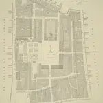
1 : 960 A pecked line marks the parish boundary of St Paul's, Covent Carden. Covent Garden was the metropolitan estate of the Russell family: the earls and dukes of Bedford. Bedford House, built in 1586 for the third earl of Bedford, appears to have been an important boundary marker. The development of the area in the 1630s saw it become the first suburb outside the City to be financed by the leasehold system and regulated by building covenants. These factors, combined with Inigo Jones' architecture, made Covent Garden a prototype which was aspired to for the next 250 years. Lyborn, William
$title$

A MAPP of the Parish of St PAULS COVENT GARDEN taken from the last Survey By Blome, Richard

Richard Blome was the acting editor of Stow's Survey at this time. Pecked lines show parish boundaries. Bedford House and garden appear on this map. Built in 1586 to replace the Earls of Bedford's earlier mansion on the south side of the Strand, it was demolished in 1706, making way for Southampton Street, Tavistock Street and Tavistock Row. Covent Garden was the metropolitan estate of the Earls and Dukes of Bedford, whose family name was Russell. They later came to own much of Bloomsbury, hence the name of Russell Square. Blome, Richard
$title$

A Plan of the Parish of St Paul's Covent Garden

This is a 19th-Century copy of a map from the beginning of the previous century. It shows Old Bedford House in the Strand. Individual houses around the piazza in Covent Garden are numbered. The New Exchange is marked on the Strand. This was a very smart shopping arcade completed in 1609, taking over much of the trade of the Royal Exchange after it was destroyed in the Great Fire. Historian and biographer John Strype described it in 1720 as ''a place of great resort and trade for the nobility and gentry.''
$title$

PART of WESTMINSTER at large shewing the IMPROVEMENTS propos'd about LEICESTER-FIELDS, COVENT-GARDEN, the MEWSE & c.

Trafalgar Square is named Kings Square on this plan and Leicester Square is called Leicester Fields. The new plan is superimposed on the layout of the old. Red lines show new streets in a grid-like formation replacing older and narrower streets and buildings. Gwynn, John
$title$

Plan Proposed for WIDENING THE STRAND in the Vicinity of EXETER 'CHANGE.

1 : 720 This plan was ordered by the House of Commons.The Exeter Exchange (or 'Change') was an arcade of luxury shops. Beside the areas of proposed renovation, a glass-roof bazaar is shown. Buildings would have to be demolished to make way for this feature. A note in the margins reports that the plan is taken from the "FIFTH REPORT OF THE COMMISSIONER OF HIS MAJESTY'S WOODS, FORESTS, AND LAND REVENUE - 1826." Arrowsmith, A.
$title$

PLAN OF BEDFORD HOUSE, COVENT GARDEN, &c. TAKEN ABOUT 1690

This map is copied from a 1690 drawing in Crowle's Pennant, held in the British Museum. Annotations appear across the drawing, recording local history before and after 1690. For example, in St Paul's churchyard is mentioned Marmaduke Conway, who died in 1717 at the age of 108 having never lost a single tooth. It also shows the location of Bedford House, which had been taken down over a century earlier. Around the border of the map are more informative gems, such as the location of a house named ''Two Golden Balls'' which in 1711 was famous for magical entertainments. Smith, John Thomas
$title$

Insurance Plan of London Vol. VIII: sheet 191

1 : 480 This detailed 1888 plan of London is one of a series of twenty-six sheets in an atlas originally produced to aid insurance companies in assessing fire risks. The building footprints, their use (commercial, residential, educational, etc.), the number of floors and the height of the building, as well as construction materials (and thus risk of burning) and special fire hazards (chemicals, kilns, ovens) were documented in order to estimate premiums. Names of individual businesses, property lines, and addresses were also often recorded. Together these maps provide a rich historical shapshot of the commercial activity and urban landscape of towns and cities at the time. The British Library holds a comprehensive collection of fire insurance plans produced by the London-based firm Charles E. Goad Ltd. dating back to 1885. These plans were made for most important towns and cities of the British Isles at the scales of 1:480 (1 inch to 40 feet), as well as many foreign towns at 1:600 (1 inch to 50 feet). Chas E Goad Limited Chas E Goad Limited
$title$

Insurance Plan of London Vol. VIII: sheet 190

1 : 480 This detailed 1888 plan of London is one of a series of twenty-six sheets in an atlas originally produced to aid insurance companies in assessing fire risks. The building footprints, their use (commercial, residential, educational, etc.), the number of floors and the height of the building, as well as construction materials (and thus risk of burning) and special fire hazards (chemicals, kilns, ovens) were documented in order to estimate premiums. Names of individual businesses, property lines, and addresses were also often recorded. Together these maps provide a rich historical shapshot of the commercial activity and urban landscape of towns and cities at the time. The British Library holds a comprehensive collection of fire insurance plans produced by the London-based firm Charles E. Goad Ltd. dating back to 1885. These plans were made for most important towns and cities of the British Isles at the scales of 1:480 (1 inch to 40 feet), as well as many foreign towns at 1:600 (1 inch to 50 feet). Chas E Goad Limited Chas E Goad Limited
$title$

Insurance Plan of London Vol. VIII: sheet 189

1 : 480 This detailed 1888 plan of London is one of a series of twenty-six sheets in an atlas originally produced to aid insurance companies in assessing fire risks. The building footprints, their use (commercial, residential, educational, etc.), the number of floors and the height of the building, as well as construction materials (and thus risk of burning) and special fire hazards (chemicals, kilns, ovens) were documented in order to estimate premiums. Names of individual businesses, property lines, and addresses were also often recorded. Together these maps provide a rich historical shapshot of the commercial activity and urban landscape of towns and cities at the time. The British Library holds a comprehensive collection of fire insurance plans produced by the London-based firm Charles E. Goad Ltd. dating back to 1885. These plans were made for most important towns and cities of the British Isles at the scales of 1:480 (1 inch to 40 feet), as well as many foreign towns at 1:600 (1 inch to 50 feet). Chas E Goad Limited Chas E Goad Limited
$title$

Insurance Plan of London Vol. VIII: sheet 184

1 : 480 This detailed 1888 plan of London is one of a series of twenty-six sheets in an atlas originally produced to aid insurance companies in assessing fire risks. The building footprints, their use (commercial, residential, educational, etc.), the number of floors and the height of the building, as well as construction materials (and thus risk of burning) and special fire hazards (chemicals, kilns, ovens) were documented in order to estimate premiums. Names of individual businesses, property lines, and addresses were also often recorded. Together these maps provide a rich historical shapshot of the commercial activity and urban landscape of towns and cities at the time. The British Library holds a comprehensive collection of fire insurance plans produced by the London-based firm Charles E. Goad Ltd. dating back to 1885. These plans were made for most important towns and cities of the British Isles at the scales of 1:480 (1 inch to 40 feet), as well as many foreign towns at 1:600 (1 inch to 50 feet). Chas E Goad Limited Chas E Goad Limited
$title$

Insurance Plan of London Vol. VIII: sheet 194

1 : 480 This detailed 1888 plan of London is one of a series of twenty-six sheets in an atlas originally produced to aid insurance companies in assessing fire risks. The building footprints, their use (commercial, residential, educational, etc.), the number of floors and the height of the building, as well as construction materials (and thus risk of burning) and special fire hazards (chemicals, kilns, ovens) were documented in order to estimate premiums. Names of individual businesses, property lines, and addresses were also often recorded. Together these maps provide a rich historical shapshot of the commercial activity and urban landscape of towns and cities at the time. The British Library holds a comprehensive collection of fire insurance plans produced by the London-based firm Charles E. Goad Ltd. dating back to 1885. These plans were made for most important towns and cities of the British Isles at the scales of 1:480 (1 inch to 40 feet), as well as many foreign towns at 1:600 (1 inch to 50 feet). Chas E Goad Limited Chas E Goad Limited
$title$

Insurance Plan of London Vol. VIII: sheet 188

1 : 480 This detailed 1888 plan of London is one of a series of twenty-six sheets in an atlas originally produced to aid insurance companies in assessing fire risks. The building footprints, their use (commercial, residential, educational, etc.), the number of floors and the height of the building, as well as construction materials (and thus risk of burning) and special fire hazards (chemicals, kilns, ovens) were documented in order to estimate premiums. Names of individual businesses, property lines, and addresses were also often recorded. Together these maps provide a rich historical shapshot of the commercial activity and urban landscape of towns and cities at the time. The British Library holds a comprehensive collection of fire insurance plans produced by the London-based firm Charles E. Goad Ltd. dating back to 1885. These plans were made for most important towns and cities of the British Isles at the scales of 1:480 (1 inch to 40 feet), as well as many foreign towns at 1:600 (1 inch to 50 feet). Chas E Goad Limited Chas E Goad Limited
$title$

Insurance Plan of London Vol. VIII: sheet 183

1 : 480 This detailed 1888 plan of London is one of a series of twenty-six sheets in an atlas originally produced to aid insurance companies in assessing fire risks. The building footprints, their use (commercial, residential, educational, etc.), the number of floors and the height of the building, as well as construction materials (and thus risk of burning) and special fire hazards (chemicals, kilns, ovens) were documented in order to estimate premiums. Names of individual businesses, property lines, and addresses were also often recorded. Together these maps provide a rich historical shapshot of the commercial activity and urban landscape of towns and cities at the time. The British Library holds a comprehensive collection of fire insurance plans produced by the London-based firm Charles E. Goad Ltd. dating back to 1885. These plans were made for most important towns and cities of the British Isles at the scales of 1:480 (1 inch to 40 feet), as well as many foreign towns at 1:600 (1 inch to 50 feet). Chas E Goad Limited Chas E Goad Limited
$title$

Plan of the property of Lady Acheson, Moor's Yard, St. Martin's Lane, and the Strand. 1689

1 : 264 This is a copy made by Crace in 1842 of a plan in the Gough Collection. Crace liked to have copies of maps even if they were only tracings. This plan shows the properties of a Lady Acheson, with the names of tenants recorded in each case. Frederick Crace
$title$

Insurance Plan of London Vol. VIII: sheet 185

1 : 480 This detailed 1888 plan of London is one of a series of twenty-six sheets in an atlas originally produced to aid insurance companies in assessing fire risks. The building footprints, their use (commercial, residential, educational, etc.), the number of floors and the height of the building, as well as construction materials (and thus risk of burning) and special fire hazards (chemicals, kilns, ovens) were documented in order to estimate premiums. Names of individual businesses, property lines, and addresses were also often recorded. Together these maps provide a rich historical shapshot of the commercial activity and urban landscape of towns and cities at the time. The British Library holds a comprehensive collection of fire insurance plans produced by the London-based firm Charles E. Goad Ltd. dating back to 1885. These plans were made for most important towns and cities of the British Isles at the scales of 1:480 (1 inch to 40 feet), as well as many foreign towns at 1:600 (1 inch to 50 feet). Chas E Goad Limited Chas E Goad Limited
$title$

A plan, in Indian ink, of the Adelphi Terrace and the adjoining streets; drawn on a scale of 30 feet to an inch

$title$

Insurance Plan of London Vol. VIII: sheet 195

1 : 480 This detailed 1888 plan of London is one of a series of twenty-six sheets in an atlas originally produced to aid insurance companies in assessing fire risks. The building footprints, their use (commercial, residential, educational, etc.), the number of floors and the height of the building, as well as construction materials (and thus risk of burning) and special fire hazards (chemicals, kilns, ovens) were documented in order to estimate premiums. Names of individual businesses, property lines, and addresses were also often recorded. Together these maps provide a rich historical shapshot of the commercial activity and urban landscape of towns and cities at the time. The British Library holds a comprehensive collection of fire insurance plans produced by the London-based firm Charles E. Goad Ltd. dating back to 1885. These plans were made for most important towns and cities of the British Isles at the scales of 1:480 (1 inch to 40 feet), as well as many foreign towns at 1:600 (1 inch to 50 feet). Chas E Goad Limited Chas E Goad Limited
$title$

Insurance Plan of London Vol. VIII: sheet 193

1 : 480 This detailed 1888 plan of London is one of a series of twenty-six sheets in an atlas originally produced to aid insurance companies in assessing fire risks. The building footprints, their use (commercial, residential, educational, etc.), the number of floors and the height of the building, as well as construction materials (and thus risk of burning) and special fire hazards (chemicals, kilns, ovens) were documented in order to estimate premiums. Names of individual businesses, property lines, and addresses were also often recorded. Together these maps provide a rich historical shapshot of the commercial activity and urban landscape of towns and cities at the time. The British Library holds a comprehensive collection of fire insurance plans produced by the London-based firm Charles E. Goad Ltd. dating back to 1885. These plans were made for most important towns and cities of the British Isles at the scales of 1:480 (1 inch to 40 feet), as well as many foreign towns at 1:600 (1 inch to 50 feet). Chas E Goad Limited Chas E Goad Limited
$title$

GROUND PLAN of an ESTATE Situate at Seven Dials in the Parish of ST.GILES in the FIELDS, Surveyed 1811 by H. LANE, 1 London Street, Fitzroy Square

1 : 300 This plan covers the area of the Seven Dials, a street formation of seven streets radiating from a central point. Thomas Neale, Master of the Mint began the development of the complex in 1693. The project was completed around 1710. In 1694 John Evelyn went to see the building work and commented on the star formation radiating from a point marked by a Doric pillar. This pillar was removed in 1773 as it had become a meeting place for criminals, partly due to a false rumour that a large sum of money had been buried at its base. Although intended as a smart residential area, it became the haunt of thieves and street vendors in the 18th and 19th centuries. The building of Shaftsbury Avenue and Charing Cross Road reduced the area to little more than a junction. Hewitt
$title$

A MAPP of the Parish of St MARTINS in the FIELDS, taken from ye last survey, with Additions By Blome, Richard.

1 : 3600 This plan of the parish of St Martins in the Fields shows the Banqueting House at Whitehall, the New Exchange on the Strand and Northumberland House.Near the top of the plate, the southern part of today's Leicester Square is indicated with the name of Leicester Fields. The equestrian statue of Charles I is depicted at Charing Cross. A pecked line marks the boundaries with the neighbouring parishes of St James and St Giles. Blome, Richard
$title$

London VII.63 - OS London Town Plan

1 : 1056 Topographic maps Ordnance Survey Ordnance Survey
$title$

Plan of Kingsway, From Report of the Royal Commission on cross-river traffic in London, Plate XVIII

$title$

General Plan, shewing the whole line of the Proposed New Street to the British Museum

1 : 4800 A plan of the proposed street running to the British Museum in Bloomsbury. Ingrey & Madeley's
$title$

A Mapp of the Parishes of {ST.CLEMENTS DANES, ST. MARY SAVOY; with the Rolls Liberty and Lincolns Inn. taken From the last Survey with Corrections and Additions 50

1 : 2616 This is the second edition of Blome's map. His name was removed from the cartouche because Strype had taken over as editor of the project. The map shows in elevation the Savoy, Somerset House and gardens, Exeter Exchange and temple, and Lincoln's Inn. The church, St Mary-le-Strand, opposite Somerset House was absent from the earlier edition. It is shown here in plan, but is unnamed and not referred to in the numerical key. Blome, Richard
$title$

A Plan of the intended improvements from Charing Cross to Bedford Square

A plan of intended improvements from Charing Cross to Bedford Square. Sawyer, Henry
$title$

PLAN B. PROPOSED NEW STREET from BOW STREET TO CHARLOTTE STREET. As Revised June 1840

1 : 648 This plan was commissioned by the House of Parliament and shows the proposed new street from Long Acre to Broad Street in the parish of St Giles's, London. Day & Hague
$title$

MAP OF THE Manor of the Savoy AND OF THE LIBERTY OF THE DUCHY OF LANCASTER CALLED The Savoy Liberty, In the County of Middlesex. 1830

1 : 1128 The Savoy Liberty is divided into four wards which are delineated by different pastle shades, an explanation of which appears in the table. St Mary-le-Strand and the Site of the Lyceum Theatre, now in ruins, are shown, as is the ancient site of Burliegh House. Madeley, G. E.
$title$

Drawn Plan of a new Street from Piccadilly to King Street, Covent Garden

1 : 960 A 19th Century copy of a plan in the Gough Collection, Oxford, dating back to 1766 and showing the new streets connecting Piccadilly to King Street in Covent Garden, London.
$title$

Plan D. PROPOSED NEW STREET from COVENTRY STREET to LONG ACRE. As Revised June 1840.

1 : 852 This plan was ordered by the House of Commons and is titled in the top right border ''FIRST REPORT ON METROPOLIS IMPROVEMENTS - 1840''. It shows the extension of Longacre into Leicester Square, beyond to Princes Street and the widening of Upper St Martin's Lane. The areas coloured pink are those thatneed to be destroyed to make way for the improvements.
$title$

Drawn Plan of the Property around Leicester Square

1 : 1200 Drawn plan of thr properties around Leicester Square showing the proposed changes to the street plan in red ink and facades of new buildings in elevation at the top and down the left side of the plate.
© MapTiler © OpenStreetMap contributors
How does it work?
These instructions will show you how to find historical maps online.
Getting started
Type the place name in the search box to find the exact location. You can further adjust the search by zooming in and out.
Zoom
Zoom in and out with the buttons or use your mouse or touchpad natively.
Exact Area tool
Click here and draw a rectangle over the map to precisely define the search area.
Set filters
Narrow your search with advanced settings, such as Years (from/to), Fulltext, Publisher, etc.
Results
See the results of your search on the right side. You can scroll down to find more maps of this location.
?

Download OldMapsOnline Mobile