Maps of Islington

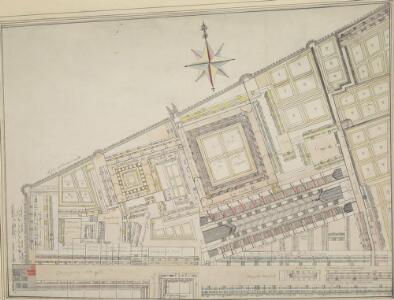
Drawn Plan of the Grey Friars Precinct
This is an 18th-Century copy of Ralph Treswell's 1610 survey of the Precinct of Grey Friars. Although better known as painter in his lifetime, Ralph Treswell was also a mapmaker and one of the first land surveyors of the modern era. The plan features compass star at top centre. The London Wall, Christ Church and Cloisters, private tenements, and the market on Newgate Street are all shown pictorially.
Insurance Plan of City of London Vol. II: sheet 40
1 : 480 This detailed 1886 plan of London is one of a series of twenty sheets in an atlas originally produced to aid insurance companies in assessing fire risks. The building footprints, their use (commercial, residential, educational, etc.), the number of floors and the height of the building, as well as construction materials (and thus risk of burning) and special fire hazards (chemicals, kilns, ovens) were documented in order to estimate premiums. Names of individual businesses, property lines, and addresses were also often recorded. Together these maps provide a rich historical shapshot of the commercial activity and urban landscape of towns and cities at the time. The British Library holds a comprehensive collection of fire insurance plans produced by the London-based firm Charles E. Goad Ltd. dating back to 1885. These plans were made for most important towns and cities of the British Isles at the scales of 1:480 (1 inch to 40 feet), as well as many foreign towns at 1:600 (1 inch to 50 feet). Chas E Goad Limited Chas E Goad Limited
Insurance Plan of City of London Vol. II: sheet 39-2
1 : 480 This detailed 1886 plan of London is one of a series of twenty sheets in an atlas originally produced to aid insurance companies in assessing fire risks. The building footprints, their use (commercial, residential, educational, etc.), the number of floors and the height of the building, as well as construction materials (and thus risk of burning) and special fire hazards (chemicals, kilns, ovens) were documented in order to estimate premiums. Names of individual businesses, property lines, and addresses were also often recorded. Together these maps provide a rich historical shapshot of the commercial activity and urban landscape of towns and cities at the time. The British Library holds a comprehensive collection of fire insurance plans produced by the London-based firm Charles E. Goad Ltd. dating back to 1885. These plans were made for most important towns and cities of the British Isles at the scales of 1:480 (1 inch to 40 feet), as well as many foreign towns at 1:600 (1 inch to 50 feet). Chas E Goad Limited Chas E Goad Limited
Drawn Plan of the Property East of Grey Friars
1 : 132 This is an 18th-Century copy of Ralph Treswell's 1610 survey of the property East of Grey Friars. Although better known as a painter in his lifetime, Ralph Treswell was also a mapmaker and one of the first land surveyors of the modern era. The plan features a scale bar at the top centre, with orientation points marked on the margins.; The facades of the various private tenements and the Shambles on Newgate Street are shown pictorially.
Drawn Plan of the Property of St. Bartholomew's Hospital] 9
This is an18th-Century copy of a Ralph Treswell's 1610 plan of the property of St Bartholomew's Hospital. While better known as a painter in his lifetime, Ralph Treswell was also a mapmaker and one of the first surveyors of the modern era. This plan features a compass star in the middle and a scale bar in a table at the bottom left. London's Roman wall, Christ's Hospital and the properties along the way to St. Bartholomew's Hospital are all shown pictorially.
Insurance Plan of City of London Vol. II: sheet 41
1 : 480 This detailed 1886 plan of London is one of a series of twenty sheets in an atlas originally produced to aid insurance companies in assessing fire risks. The building footprints, their use (commercial, residential, educational, etc.), the number of floors and the height of the building, as well as construction materials (and thus risk of burning) and special fire hazards (chemicals, kilns, ovens) were documented in order to estimate premiums. Names of individual businesses, property lines, and addresses were also often recorded. Together these maps provide a rich historical shapshot of the commercial activity and urban landscape of towns and cities at the time. The British Library holds a comprehensive collection of fire insurance plans produced by the London-based firm Charles E. Goad Ltd. dating back to 1885. These plans were made for most important towns and cities of the British Isles at the scales of 1:480 (1 inch to 40 feet), as well as many foreign towns at 1:600 (1 inch to 50 feet). Chas E Goad Limited Chas E Goad Limited
Drawn Plan of the Property of St. Bartholomew's Hospital] 9
1 : 480 This is an 18th Century copy of Ralph Treswell's 1610 plan of the property of St. Bartholomew's. Orientation points are marked on margins with St. Bartholomew's Hospital and the adjacent church and churchyard shown pictorially. Although better known as a painter in his lifetime, Ralph Treswell was also a mapmaker and one of the first surveyors of the modern era.
Drawn Plan of the Property of St. Bartholomew's Hospital] 9
This is an 18th-Century copy of Ralph Treswell's plan of the property of St. Bartholomew's Hospital. A painter by trade, Treswell was also a mapmaker and one of the first surveyors of the modern era. The plan features orientation points marked on margins. The tenements in St. Bartholomew's Estate, St. Sepulchre's Churchyard, the ditch running from Smithfield Bars to the Common Shore and Smithfield are shown pictorially.
Drawn Plan of the Property of St. Barholomew's Hospital from Christ's Hospital to Smithfield
This is an 18th Century copy of Ralph Treswell's 1610 plan of the property of St. Bartholomew's Hospital. Although better known as a painter in his lifetime, Treswell was also a mapmaker and one of the first surveyors of the modern era. The plan features compass star and scale bar at top right, showing the Roman wall, Christ's Hospital and the properties along the way to St. Bartholomew's Hospital pictorially.
BAYNARDS CASTLE AND FARINGDON WARD WITHIN with their Divisions into Parishes according to a new SURVEY.
1 : 3600 This plan was published in William Maitland's 'History of London from its Foundation to the Present Time'. Its title features in cartouche at lower left, with the arms of Sir Robert Ladbrook, Alderman of Baynord Castle, and William Bridgen, Alderman of Farringdon Within, at bottom left. The compass star appears at bottom centre. An illustrated view of St Bennet's Church is at top left, with St Martin's Church at top right and St. Andrew's church at bottom right. Maitland's ward plans were largely derived from Strype's plans, with the illustrations copied from West Tow's 1736 'Prospect Views of Ancient Churches'. Farringdon Ward was divided into Farringon Within and Farringdon Without in 1394 because "the governance thereof is too laborious and grievous for one person to occupy and duly govern the same." Cole, B.
FARINGTON within and BAYNARD CASTLE with its Divisions into Parishes taken from the last Survey with Corrections. 23A
1 : 2400 This plan was published in Strype's first annotated edition of Stow's 'Survey of England'. The plan's title features in cartouche at top left, with compass star and scale bar near bottom left. The keys to streets, yards, halls, courts and private properties appear in tables down both sides of the plate. St. Paul's Cathedral and other prominent buildings are shown pictorially. Farringdon Ward was divided into Farringon Within and Farringdon Without in 1394 because "the governance thereof is too laborious and grievous for one person to occupy and duly govern the same". Blome, Richard
ALDERSGATE WARD with its DIVISIONS into Precincts and Parishes And the Liberty of St. Martins le Grand, according to a NEW SURVEY
1 : 2400 This plan was published in William Maitlan's 'History of London from its Foundation to the Present Time'. The plan's title features in cartouche at top left, with the arms of the Alderman William Benn, to whom the plan is dedicated, at top right. A view of St Anne Agnes' Church is included at bottom left, with compass star and scale bar at bottom centre, and a view of St Botolph's church at bottom right. Maitland's ward plans were largely derived from Strype's plans, with the illustrations copied from West Tow's 1736 'Prospect Views of Ancient Churches'. Cole, B.
A PLAN OF THE WARD OF ALDERSGATE
1 : 1477 The title of this plan appears along the top, with the scale bar, compass star and dedication to the ward Alderman Richard Levell at bottom centre. The plan also features views of Sts Anne Agnes Church, at bottom right, and St Botolph's Church. Views of the north and south side of the Alder's Gate are depicted at bottom left and top right. A descriptive note is in a panel below the plan. Ilive, Jacob
ALDERSGATE WARD and St. Martins le Grand Liberty taken from the last Survey, with Corrections 1A
1 : 2400 This plan is taken from Strype's first annotated edition of Stow's 'Survey of England'. The plan's title features in banner at top left, with scale bar at bottom left. The key to streets, yards, halls, courts and private properties appears down the left side of the plate and at top right. Blome, Richard
London VII.65 - OS London Town Plan
1 : 1056 Topographic maps Ordnance Survey Ordnance Survey
CASTLE-BAYNARD WARD A New Survey 1794.
1 : 1800 This is a 19th-Century tracing of an original 1794 plan of the Castle Baynard ward in the City of London. The plan's title features at top left below the city arms, with scale bar at bottom centre. It also shows the ground plan of St. Paul's Cathedral and Newgate market.
Proposed Plan for improving the Approaches to the Metropolitan Meat Market, Smithfield, and Railway Stations; and for reducing the Acclivities of Holborn Hill, Skinner street, etc
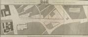
PLAN OF THE CITYS INTENDED IMPROVEMENT AT SNOW HILL
1 : 4800 This plan shows the widening and continuation of the road at Snow Hill. The properties within the route of expansion are numbered and lettered, indicating that they are to be purchased to allow for the development. Metcalf, R.
Insurance Plan of City of London Vol. I: sheet 9
1 : 480 This detailed 1886 plan of London is one of a series of twenty-five sheets in an atlas originally produced to aid insurance companies in assessing fire risks. The building footprints, their use (commercial, residential, educational, etc.), the number of floors and the height of the building, as well as construction materials (and thus risk of burning) and special fire hazards (chemicals, kilns, ovens) were documented in order to estimate premiums. Names of individual businesses, property lines, and addresses were also often recorded. Together these maps provide a rich historical shapshot of the commercial activity and urban landscape of towns and cities at the time. The British Library holds a comprehensive collection of fire insurance plans produced by the London-based firm Charles E. Goad Ltd. dating back to 1885. These plans were made for most important towns and cities of the British Isles at the scales of 1:480 (1 inch to 40 feet), as well as many foreign towns at 1:600 (1 inch to 50 feet). Chas E Goad Limited Chas E Goad Limited
Insurance Plan of London Vol. 1: sheet 9
1 : 480 This detailed 1904 plan of London is one of a series of twenty-five sheets in an atlas originally produced to aid insurance companies in assessing fire risks. The building footprints, their use (commercial, residential, educational, etc.), the number of floors and the height of the building, as well as construction materials (and thus risk of burning) and special fire hazards (chemicals, kilns, ovens) were documented in order to estimate premiums. Names of individual businesses, property lines, and addresses were also often recorded. Together these maps provide a rich historical shapshot of the commercial activity and urban landscape of towns and cities at the time. The British Library holds a comprehensive collection of fire insurance plans produced by the London-based firm Charles E. Goad Ltd. dating back to 1885. These plans were made for most important towns and cities of the British Isles at the scales of 1:480 (1 inch to 40 feet), as well as many foreign towns at 1:600 (1 inch to 50 feet). Chas E Goad Limited Chas E Goad Limited
Insurance Plan of City of London Vol. II: sheet 43
1 : 480 This detailed 1886 plan of London is one of a series of twenty sheets in an atlas originally produced to aid insurance companies in assessing fire risks. The building footprints, their use (commercial, residential, educational, etc.), the number of floors and the height of the building, as well as construction materials (and thus risk of burning) and special fire hazards (chemicals, kilns, ovens) were documented in order to estimate premiums. Names of individual businesses, property lines, and addresses were also often recorded. Together these maps provide a rich historical shapshot of the commercial activity and urban landscape of towns and cities at the time. The British Library holds a comprehensive collection of fire insurance plans produced by the London-based firm Charles E. Goad Ltd. dating back to 1885. These plans were made for most important towns and cities of the British Isles at the scales of 1:480 (1 inch to 40 feet), as well as many foreign towns at 1:600 (1 inch to 50 feet). Chas E Goad Limited Chas E Goad Limited
Insurance Plan of City of London Vol. I: sheet 10
1 : 480 This detailed 1886 plan of London is one of a series of twenty-five sheets in an atlas originally produced to aid insurance companies in assessing fire risks. The building footprints, their use (commercial, residential, educational, etc.), the number of floors and the height of the building, as well as construction materials (and thus risk of burning) and special fire hazards (chemicals, kilns, ovens) were documented in order to estimate premiums. Names of individual businesses, property lines, and addresses were also often recorded. Together these maps provide a rich historical shapshot of the commercial activity and urban landscape of towns and cities at the time. The British Library holds a comprehensive collection of fire insurance plans produced by the London-based firm Charles E. Goad Ltd. dating back to 1885. These plans were made for most important towns and cities of the British Isles at the scales of 1:480 (1 inch to 40 feet), as well as many foreign towns at 1:600 (1 inch to 50 feet). Chas E Goad Limited Chas E Goad Limited
Plan of the improvements at Snowhill
1 : 1200 Snowhill is a steep hill extending from Central Markets to Holborn Viaduct. The plan shows improvements at Snowhill which predate the building of the viaduct in 1869. Woodthorpe, V.
Insurance Plan of City of London Vol. II: sheet 42
1 : 480 This detailed 1886 plan of London is one of a series of twenty sheets in an atlas originally produced to aid insurance companies in assessing fire risks. The building footprints, their use (commercial, residential, educational, etc.), the number of floors and the height of the building, as well as construction materials (and thus risk of burning) and special fire hazards (chemicals, kilns, ovens) were documented in order to estimate premiums. Names of individual businesses, property lines, and addresses were also often recorded. Together these maps provide a rich historical shapshot of the commercial activity and urban landscape of towns and cities at the time. The British Library holds a comprehensive collection of fire insurance plans produced by the London-based firm Charles E. Goad Ltd. dating back to 1885. These plans were made for most important towns and cities of the British Isles at the scales of 1:480 (1 inch to 40 feet), as well as many foreign towns at 1:600 (1 inch to 50 feet). Chas E Goad Limited Chas E Goad Limited
Insurance Plan of City of London Vol. II: sheet 39-1
1 : 480 This detailed 1886 plan of London is one of a series of twenty sheets in an atlas originally produced to aid insurance companies in assessing fire risks. The building footprints, their use (commercial, residential, educational, etc.), the number of floors and the height of the building, as well as construction materials (and thus risk of burning) and special fire hazards (chemicals, kilns, ovens) were documented in order to estimate premiums. Names of individual businesses, property lines, and addresses were also often recorded. Together these maps provide a rich historical shapshot of the commercial activity and urban landscape of towns and cities at the time. The British Library holds a comprehensive collection of fire insurance plans produced by the London-based firm Charles E. Goad Ltd. dating back to 1885. These plans were made for most important towns and cities of the British Isles at the scales of 1:480 (1 inch to 40 feet), as well as many foreign towns at 1:600 (1 inch to 50 feet). Chas E Goad Limited Chas E Goad Limited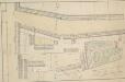
Drawn Plan of the Property of St. Bartholomew's Hospital] 9
1 : 120 This is an 18th-Century copy of Ralph Treswell's 1610 plan of the property of St. Bartholomew's Hospital. A painter by trade, Ralph Treswell was also a mapmaker and one of the first surveyors of the modern era. This plan features scale bars at bottom right and orientation points marked on margins. Private properties and tenements along Hosier Lane and the west side of Smithfield are shown pictorially.
FARRINGDON WARD without WITH ITS Divisions into Parishes taken from the last Survey with Corrections and Amendm.ts 24A
1 : 3600 This plan was published in Strype's first annotated edition of Stow's 'Survey of England'. The plan's title features in banner at the top of the plate, with a compass star at middle left. The key to streets, yards, halls, courts and private properties appears in a table at lower right, with the wards prominent buildings shown pictorially. Farringdon ward was divided into Farringon Within and Farringdon Without in 1394 because "the governance thereof is too laborious and grievous for one person to occupy and duly govern the same". Blome, Richard
FARRINGDON WARD without WITH ITS Divisions into Parishes taken from the last Survey with Corrections and Amendm.ts 26
1 : 3600 This plan was published in William Maitland's 'History of London from its Foundation to the Present Time'. The plan's title features in cartouche at top left, with the heraldic arms of dedicatee Richard Beckford, the ward Alderman, at top centre. A view of Temple Bar appears at top right, with view of Bridewell North Gate next to the compass star at bottom right. Maitland's ward plans were largely derived from Strype's, with the illustrations copied from West Tow's 1736 'Prospect Views of Ancient Churches'. Farringdon Ward was divided into Farringon Within and Farringdon Without in 1394 because "the governance thereof is too laborious and grievous for one person to occupy and duly govern the same". Cole, B.
Insurance Plan of City of London Vol. II: Key Plan
1 : 480 This "key plan" indicates coverage of the Goad 1886 series of fire insurance maps of London that were originally produced to aid insurance companies in assessing fire risks. The building footprints, their use (commercial, residential, educational, etc.), the number of floors and the height of the building, as well as construction materials (and thus risk of burning) and special fire hazards (chemicals, kilns, ovens) were documented in order to estimate premiums. Names of individual businesses, property lines, and addresses were also often recorded. Together these maps provide a rich historical shapshot of the commercial activity and urban landscape of towns and cities at the time. The British Library holds a comprehensive collection of fire insurance plans produced by the London-based firm Charles E. Goad Ltd. dating back to 1885. These plans were made for most important towns and cities of the British Isles at the scales of 1:480 (1 inch to 40 feet), as well as many foreign towns at 1:600 (1 inch to 50 feet). Chas E Goad Limited Chas E Goad Limited