Maps of Camden

Maps of Camden

$title$

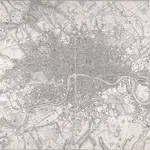
LONDON Drawn and engraved expressly for the POST OFFICE DIRECTORY

Map of London published by Benjamin Rees Davies for the Post Office Directory with title and scale bar in table at top right. The London post codes W, N, N.E., E, S.E., S and S.W. are indicated. Davies, Benjamin Rees
$title$

London : guide to the International Exhibition, 1862

1 : 15840 Dower, John, fl. 1838-1846? Illustrated London News
$title$

Stanford’s Map of London, shewing the Areas granted to the Electric Light Supply Companies

Edward STANFORD
$title$

KAART van LONDEN enz en van het NABY GELEGEN LAND ruim een Uur gaans. rondsom dezelve Stad; getrokken uit de groote gemeeten Kaart van de Hr. JOHN ROCQUE, Te AMSTERDAM by ISAAK TIRION 1754

In the second half of the18th century, the introduction of turnpike roads and the increased coach-traffic in and out of London contributed to the popularity of the maps of the countryside around the capital. This map of the area ten miles round the City of London was published in Amsterdam by Isaak Tirion. Based on John Rocque's survey of 1744, the map’s title, imprint and key appears in a table at top left. The scale bars are in a panel below the plan. Built-up areas are stippled in the City and hatched elsewhere. Tirion, Isaak
$title$

Kaart van Londen enz. en van het naby gelegen land ruim een uur gaans rondom dezelve stad : getrokken uit de groote gemeeten kaart van de Hr. John Rocque

1 : 63500 Amstersdam : Isaak Tirion
$title$

CRUCHLEY'S New Plan of LONDON and its ENVIRONS

This map is the 11th edition of Cruchley's 'New Plan'. It was altered on each publication, recording the many developments than spanned this period, particularly railway expansion. In this edition the Waterloo and Bricklayers Arms stations are shown, as are Battersea and Victoria Parks. Prior to the establishment of his own business, Cruchley worked for the Arrowsmiths map-publishing firm. Consequently the words “from Arrowsmiths" appear in his imprint on many of his early maps. George Frederick Cruchley
$title$

LONDON AND ITS ENVIRONS LEVELS TAKEN BY ORDER OF THE COMMISSIONERS OF SEWERS

The cholera outbreaks of the 1830s and 1840s forced the government to make drastic improvements to the methods of drainage and sewage disposal in London. A Metropolitan Commission of Sewers was charged with the central task of unifying the existing piecemeal drainage system and forming a plan for a completely new one. A new map showing the levels of the land to be drained was needed for this. In March 1848, officers of the Royal Engineers began to prepare stations for triangulation. Observation posts were set up on one of the towers of Westminster Abbey and over the cross of St Paul's. This map is the result of the survey, showing the relative altitude of the land, a necessary preamble to planning drainage systems, as sewage can only be washed away downhill. Wyld, James
$title$

DAVIES'S MAP OF THE BRITISH METROPOLIS CONTAINING THE BOUNDARIES OF THE BOROUGHS THE RAILWAYS, STATIONS & All MODERN IMPROVEMENTS

This is the second edition of a map published twice in the same year, differing from the first edition only in the publisher's imprint. The development of the railways is evident here. The boroughs and the county-court districts are marked in red capitals. Rees Davis, Benjamin
$title$

London : drawn and engraved expressly for the post office directory

1 : 253440 Kelly's Directories Ltd Kelly & Co. Ltd., Post Office Directory Office
$title$

[Recto], uit: Map of general routes / Fred J.H. Elston

1 : 12500 Elston, Fred J. H. London : General Omnibus Co.
$title$

The fourth sheet of an actual survey of the county of Middlesex in which the parishes within the bills of mortality are bounded with red to be distinguished from the others

1 Blatt : 53 x 70 cm John Rocque
$title$

METROPOLITAN BOROUGHS

This map of London was produced for the 1832 Reform Bill that established the metropolitan boroughs. The map's title features along the top; with a compass star at top right, an explanatory note at bottom right. At bottom left is a list of the 'liberties' of the city - the name given to areas exempt from the jurisdiction of the country sheriff, being subject to a separate commission of the peace (in this case royal and governmental authorities). The new boroughs are highlighted in colour, with the shaded area representing the old boundaries of London, Westminster and Southwark. Dawson, Lieut. Robert K.
$title$

LONDON 260

Only the main roads appear on this map, giving the appearance of a rather spacious capital city. The map is covered with a squared grid to allow for the easy calculation of Hackney Cab Fares. New London Bridge is shown without its approaches. Pecked lines show the intended location of the Thames tunnel. East and West India Docks are shown. Rowe, S.
$title$

The METROPOLITAN BOROUGHS As Defined by the reform Bill

This map was produced after the Reform Bill of 1831/32 that created the metropolitan boroughs of London. The title appears at bottom right, with scale bar at bottom left, London arms of at top left, and arms of Westminster at top right. Also at bottom left is a list of 'liberties' - the name given to areas exempt from the jurisdiction of the country sheriff, being subject to a separate commission of the peace (in this case royal and governmental authorities).
$title$

A new map of London and its environs : from an original survey extending 8 miles east and west, 6 1/4 miles north & south, in which all new and intended buildings, improvements, &c. are carefully inserted

1 : 17150 Thompson, Mr Reeves & Hoare
$title$

Laurie and Whittle's New map of London with its environs, &c. Including the Recent Improvements.

From Great Britain
$title$

Philip's new plan of London, 1873

1 : 18900 George Philip & Son George Philip & Son
$title$

Map of London : made from an actual survey in the years 1824, 1825, & 1826

1 : 63360 C. & J. Greenwood C. & J. Greenwood
$title$

London

From Great Britain
$title$

MOGG'S LONDON AND ITS ENVIRONS Drawn from The latest Surveys

The radius of the red circle on this map (above St. Paul's) extends for three miles around the Post Office. The Post Office was erected on the site of St Martin-le-Grand. Designed by Sir Robert Smirke, it was opened in 1829. Coloured roads represent omnibus routes. Buses gradually replaced hackney coaches after the hackney's monopoly ended in1832. The site of the 1851 Great Exhibition in Hyde Park is indicated. Mogg, E.S.
$title$

Indicator map of London : with the recent improvements, 1880

C. Smith & Son C. Smith & Son
$title$

London in miniature : with the surrounding villages, an entire new plan in which the improvements both present and intended are actually reduced (by permission) from the surveys of the several proprietors : the whole laide down from the best authorities

1 : 16000 Mogg, Edward Edward Mogg
$title$

Whitbread's new plan of London

1 : 21500 Whitbread, J J. Whitbread
$title$

London [11], uit: Geognostische Karte des Oesterreichischen Kaiserstaates mit einem grossen Theile Deutschland's u. Italien / hauptsachlich nach ... Haidinger's geognostischer Karte dieses Staates bearb. von Josef Scheda

1 : 3000000 titelvariant: General-Karte von Europa in 25 Blättern; Annotatie: Bijlage bij: General-Karte von Europa in 25 Blättern. - 1:2.592.000. - 1845-1847 Scheda, Joseph Wien : K.K. Militär. Geografisch. Institut
$title$

Bacon's map of London : with railways in operation and constructing corrected to date

Bacon & Co Bacon & Co.
$title$

NEW PLAN OF LONDON AND THE ENVIRONS from an Original Survey EXTENDING 6 3/4 Miles North & South in which all New and Intended Buildings and Improvements are carefully Inserted

This folding map is set within a decorative border. The title and imprint feature at top right, the compass star at middle right, and scale bar at bottom left. The river, open spaces and the built-up area in the city are delineated in colour. This is the fourth edition of a map first issued by Thompson in 1823, updated with the addition of St. Katherine's Dock and the housing developments in the Marylebone and Mile End areas. Thompson, George
$title$

LAURIE'S PLAN OF LONDON, WESTMINSTER AND SOUTHWARK Trigonometrically Surveyed by JOHN OUTHETT

This is a later edition of the folding map first issued by Laurie in 1837. The map features title at top right, key to colours and scale of 40 acres at bottom centre. The border of the map is divided in miles and furlongs from St Paul's Cathedral and seconds of longitude east and west of Greenwich. Laurie, Richard Holmes
$title$

Map of LONDON From Actual Survey COMPREHENDING THE Various Improvements to 1851HUMBLY DEDICATED TO Her Most Gracious Majesty QUEEN VICTORIA By the Proprietors E. RUFF & Co.

This is a later edition of the Greenwoods' map of London first issued in 1827. Set within a decorative border, the map features title at top right, view of Westminster Abbey with key to symbols and colours at bottom left and view of St. Paul's Cathedral with reference table at bottom right. Greenwood, Christopher and John
$title$

A New Map of LONDON and its ENVIRONS From an Original Survey

This London Map comprises two sheets, with title at top right, imprint below the title, compass star at middle right and the scale bar at bottom left. Set within a decorative border, the map extends beyond the built-up area of the city to include parts of Middlesex, Surrey, the Lea River Valley and Greenwich. Thompson, George
$title$

LAURIE and WHITTLE'S NEW MAP OF LONDON WITH ITS ENVIRONS

This is a later edition of Laurie and Whittle's folding map of London, first published in 1804. The title appears as an old inscription on an illustrated pyramid at top left, also showing city arms, ship, flag, anchor, flora and fauna. Explanation of symbols and abbreviations is given above the publisher's imprint at top right, with compass star at bottom centre. The border of the map is marked off in furlongs. Proposed works, including the Vauxhall and Waterloo bridges and their approaches, are highlighted in yellow. Laurie, Robert and Whittle, James
© MapTiler © OpenStreetMap contributors
How does it work?
These instructions will show you how to find historical maps online.
Getting started
Type the place name in the search box to find the exact location. You can further adjust the search by zooming in and out.
Zoom
Zoom in and out with the buttons or use your mouse or touchpad natively.
Exact Area tool
Click here and draw a rectangle over the map to precisely define the search area.
Set filters
Narrow your search with advanced settings, such as Years (from/to), Fulltext, Publisher, etc.
Results
See the results of your search on the right side. You can scroll down to find more maps of this location.
?

Download OldMapsOnline Mobile