Maps of Westminster
NEW PLAN OF LONDON
This map was printed in black on white and appeared in the “Guide to Knowledge" anthology of 1839. The map's title, imprint and scale bar appear at bottom right. It shows the proposed Thames Tunnel, linking Wapping and Rotherhithe, as well as the Hungerford Bridge and the Greenwich and Birmingham railway lines. Archer, Joshua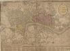
STRANGER'S GUIDE THROUGH the Streets of LONDON and WESTMINSTER
The title of this folding map appears along the top, with the sub-title in an oval at top right. A scale bar and compass star feature at the bottom right. An inset plan of Fleet Prison is included at top left. Squares, open spaces and built-up areas are all delineated in colour. Intended for visitors to the city, the map is divided into squares, with a quick-reference key in the panel below the main plan. Darton, William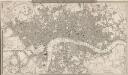
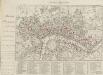
A NEW PLAN OF LONDON AND WESTMINSTER WITH THE BOROUGH OF SOUTHWARK 227
This is the second edition of a map of London first published by Wyld in 1824. Its title features inset in the top border, with publisher's imprint in the bottom border. The scale bar and key to the boundary lines appear at bottom right. The son of a map publisher, James Wyld attended military college before entering the map trade. He became one of the best-known map publishers of the middle of the 19th Century. During the railway-building mania of those years, his maps of railway developments were often put before parliament. Wyld, James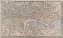
A NEW PLAN OF LONDON AND WESTMINSTER WITH THE BOROUGH OF SOUTHWARK 236
The title of this map of London appears inset in the top border, with the publisher’s imprint below the plan. Open spaces, city boundaries and boroughs are delineated in colour. The key to these colours is provided, with a scale bar, at bottom right. The map is a later edition of a map first published by Wyld in 1824, with the addition of the London-to-Greenwich railway. The line reached Bermondsey from Greenwich in 1836. Ten months later, the line reached London Bridge, making it the first railway terminus in the capital. Wyld, James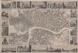
London
This is a "proof before letters", the trade term used for animpression withdrawn by the author before the title and imprint could be added for publication.The map covers London in the 1830s, and is surrounded by small pictorial views of prominent buildings and landmarks including East India House, Marble Arch, Westminster Abbey and Waterloo Bridge. Anonymous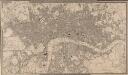
A NEW PLAN OF LONDON AND WESTMINSTER WITH THE BOROUGH OF SOUTHWARK 222
The title of this map appears in a table inset in the top border, with publisher's imprint, scale bar and an explanation of the boundary lines at bottom right. The son of a map publisher, James Wyld attended military college before entering the map trade. He became one of the best-known map publishers of the middle of the 19th Century. During the railway-building mania of those years, his maps of railway developments were often put before parliament. Wyld, James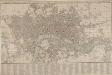
SMITH'S New Plan of LONDON, WESTMINSTER & SOUTHWARK: comprehending all the New Buildings and 350 References to the Principal Streets
First published by Smith in 1801, this popular map of London went into 27 editions, the last being issued in 1843. The title features along the top, with roads, open spaces, watercourses and the built-up area of the city delineated in colour. A reference table appears in the panel below the plan. Smith, Charles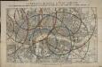
Reynolds's distance map of London, for ascertaining cab fares & shewing the distances in every direction from the railway stations &c.
James Reynolds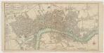
Bowles's new pocket plan of the cities of London & Westminster with the borough of Southwark : comprehending the new buidlings and other alterations to the year 1783
1 : 9800 Bowles, Carington, 1724-1793 Printed for the proprieter Carrington Bowles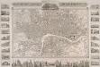
PLAN OF LONDON FROM AN ACTUAL SURVEY WITH ALL THE RAILROADS AND IMPROVEMENTS TO THE PRESENT TIME
This map of Victorian London is set within a decorative border, featuring title and publisher's imprint in a panel above the plan, and views of the city's prominent buildings and landmarks along the margins. This is a later edition of the map first published by Shury in 1832, featuring new railway lines and a pictorial view of Crystal Palace, venue of the Great Exhibition of 1851. Shury, John
Illustrated Map of London or Strangers' Guide to the Public Buildings, Theatres, Music Halls and all Places of Interest.
Smith and Son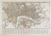
Tegg's new plan of London, &c.
T. Tegg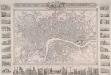
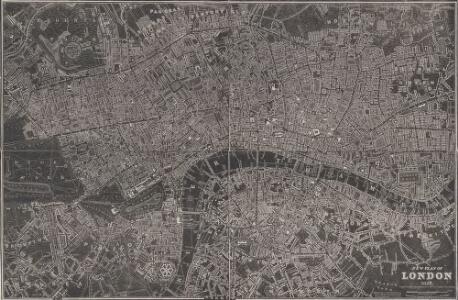
PLAN OF LONDON FROM AN ACTUAL SURVEY 243
This is a later edition of Shury's map of London first issued in 1832. The map features title along the top with the arms of the cities of London and Westminster. Down both sides of the map and along the bottom are 33 views of London buildings and landmarks. The East India House, Custom House, the Mint, St James's Palace, Christ's Hospital, the new Post Office, the bank of England, Hanover Terrace, the Corn Exchange and the Coliseum are depicted down the left side of the plate. Along the bottom are views of St Katherine's Chapel, Caledonian Church, mansion House, the Royal Exchange, Temple Bar, Guild Hall, Buckingham Palace, St Paul's Cathedral, the Monument, St Bride's Church, Lambeth Palace, Westminster Abbey and the entrance to Green Park. Down the right side of the plate are views of the House of Lords, London Bridge, the House of Commons, Waterloo Bridge, Drury Lane Theatre, Horse Guard, the King's College, Covent Garden Theatre, Somerset House and Gloucester Terrace. Shury, John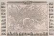
PLAN OF LONDON FROM AN ACTUAL SURVEY 233
This map was issued as a free supplementin the 'United Kingdom' newspaper.Surrounded by a decorative border, the map's title appears in a panel above the plan, with the arms of London, the royal family and the City of Westminster.Inset within the border areillustrations of prominent buildings and landmarks, including the Bank of England, Lambeth Palace, Covent Garden and Waterloo Bridge. The map shows the intended tunnel under the Thames linking Wapping and RotherhitheWhen, the firstunderwater tunnel in the world when it opened in 1843. Shury, John
CARY's New POCKET PLAN OF LONDON, WESTMINSTER and SOUTHWARK; with all the adjacent buildings in ST. GEORGE'S FIELDS &c.&c.
Pocket plans were made popular by the Bowles companying the 1730s, and had an enduring appeal. This plan, engraved by the prolific John Cary, was published 18 times. This is the first edition. It includes a list of the receiving houses appointed by the General and Penny Post Offices and a table of Hackney coach fares. The postal service in London was largely developed by William Dockwra, who responded to the demand for local letter delivery in London: non-existent until 1680, except by private messenger. Dockwra opened nearly 500 receiving houses where letters were sorted for delivering, costing the user one penny. So successful was this system that it was taken over by the General Post Office after two years. Cary, John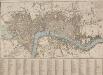
A NEW PLAN OF LONDON with the Names of the Streets Alphabetically arranged at Bottom with directions to find them in the Map
The title of this map appears along the top and with the river, city boundaries and open spaces depicted in different colours. The map is divided into numbered squares for reference, with a key in the table below the plan. Samuel Fores, better known as a publisher of sporting prints, first issued this map in 1789; this is a later edition, updated to include the housing developments of Sommers Town and St. George's Field. Fores, Samuel W.
PLAN OF LONDON FROM AN ACTUAL SURVEY 238
This map is set within a decorative border. Its title appears along the top, with the arms of the city, the royal family and Westminster. Around the margin are pictorial views of prominent buildings and landmarks, including the Bank of England, Lambeth Palace, Covent Garden and Waterloo Bridge. The map is a later edition of one first issued as a free supplement of the 'United Kingdom' newspaper in 1832, adding the Greenwich and Birmingham railway lines. Shury, John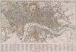
TEGG'S NEW PLAN OF LONDON, &c. WITH 360 REFERENCES TO THE PRINCIPAL STREETS &c.
The title of this folding map of London appears along the top. The city boundaries, open spaces, roads and watercourses are depicted in colour in colour. This is a later edition of a map first issued by Tegg in 1823. It is divided into rectangles for reference, with a street index in panel below the plan. Tegg, Thomas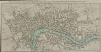
A PLAN of the CITIES of LONDON & WESTMINSTER and Borough of SOUTHWARK with the New buildings to the Year 1786.
The engraver, John Cary, was one of the most prolific English mapmakers and publishers of the 18th Century. His works were reissued many times, but unlike many of his contemporaries he aimed to update each new edition by including new developments. This map highlights in red the boundary of the old London wall. Cary, John
LEIGH'S NEW PLAN OF LONDON 213
This map was published in the first edition of 'Leigh's New Picture of London’ in 1818. It shows Southwark Bridge and the proposed New North Road, across Finsbury Fields in Islington. Leigh, Samuel
Plan of London, Westminster & Southwark

The LONDON DIRECTORY, or a New & Improved PLAN of LONDON, WESTMINSTER, & SOUTHWARK; 157
This is the eighth edition of the an original 1765Sayer map. Bennett’s name was added to the imprint of the third edition of the map, published in 1776. The two men were in partnership between 1770 and 1787.Their business was taken over by Laurie and Whittle in 1792. R. Sayer & J. Bennett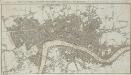
A New & accurate PLAN of the CITIES of LONDON, WSTMINSTER & BOROUGH of SOUTHWARK with the Out Parts & New Buildings completed to the Year 1791.
Born into a family of engravers, Neele issued this map twice in two years with no discernible difference between the editions. The map's title features along the top, with scale bar at upper right and publisher's imprint below the plan. City boundaries are outlined in red; squares and open spaces are highlighted in green. Neele, Samuel John
The LONDON DIRECTORY, or a New & Improved PLAN of LONDON,
Robert Sayer, the surveyor, traded as a map publisher and print seller in Fleet Street in the latter half of the 18th Century. Between 1751 and 1770and againfrom1784to 1794, he published maps under his own name or under the imprint of Sayer and Bennett. This is the 11th edition of a map published 14 times over a period of 27 years. During this time Robert Sayer became joined in partnership with John Bennett, with their joint imprint appearing on the third to eighth editions. The area of the city is highlighted in pink. A table of references for churches and public buildings appears below the map. In 1794 Sayers stock was acquired by Robert Laurie who founded the map publishing firm of Laurie & Whittle, with his friend James Whittle. Sayer, Robert
BOWLES'S Reduced NEW POCKET PLAN of the CITIES of LONDON and WESTMINSTER, with the BOROUGH of SOUTHWARK, exhibiting the NEW BUILDINGS to the YEAR 1783.
Carrington Bowles (1724-93) came from a family of publishers and map sellers who published a considerable body of work during a century of trading. This is the fifth edition of an original 1777map. It includes a table of references to churches and principal buildings. The built-up areas of the City of London are stippled, with the city and county boundaries delineated by coloured lines. The scale is given in miles or furlongs in the bottom right-hand corner. Carrington Bowles
LEIGH'S NEW PLAN OF LONDON 212
This is the second edition of a map of London first published in 'Leigh's New Picture of London'. The title appears along the top with a scale bar at the top right. The map is divided into half-mile squares with letters along the top borders for reference. It also shows Southwark Bridge and the proposed New North Road across Finsbury Fields. Hall, S.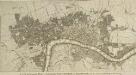
A NEW and Complete PLAN of LONDON WESTMINSTER and SOUTHWARK, with the Additional Buildings to the Year 1777.
The title of this small map of London appears in a panel below the plan. The built-up of the city is stippled while other built-up areas are hatched. This map was first issued as frontispiece to Book III of Walter Harrison's 'A New and Universal History, Description and Survey of the Cities of London and Westminster', 1776. Harrison, Walter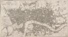
A New Plan of the Cities of LONDON, WESTMINSTER &c. &c.
The title and imprint of this map appear in a banner at the top left. The plan shows some of the improvements of the Regency period, including the new street layout of the Bedford Estate in Bloomsbury. This is the first edition of the map, which was later issued with an added sheet showing the East and West India Docks in the Isle of Dogs. Tegg, Thoams
London, Westminster, and Southwark
The map reports all the street names in London, Westminster and Southwark, with the scale bar given at bottom left. Faden, William