Maps of Tower Hamlets
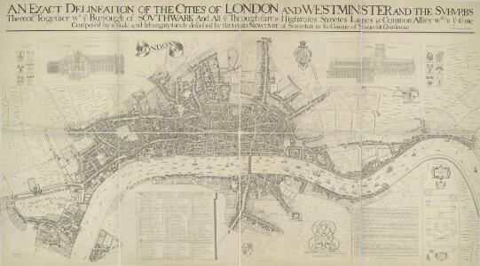
AN EXACT DELINEATION OF THE CITIES OF LONDON AND WESTMINSTER AND THE SUBURBS Thereof, Together Wth. Ye Burrough of SOUTHWARK
This is a copy of the 1658 Faithorne map made in 1857. It depicts London as it stood during the last two years of the Commonwealth, before the great fire. Dense clusters of houses appear very close together, separated only by narrow streets - an indication of the city's vulnerability to fire. Newcourt, Richard
A New Map of the Cities of London and Westminster and Ye Borough of Southwarke with their Suburbs
This is a later edition of Hollar's map of London of 1675 without the prospect view of the City entitled "Prospect of London as it was flourishing before the destruction by fire" that featured in the first edition. The map, with title in cartouche, reference tables and scale bar, is a very minute bird’s eye view of the cities of London and Westminster, with the Borough of Southwark and suburbs showing London after the fire growing in area faster than ever before, with former satellite villages fast becoming mere localities in the urban sprawl. Stepney church, for example, marks a new point of growth east of the city. Hollar, Wenceslaus
PLAN DE LA VILLE DE LONDRES
This small map of London appeared in a book entitled "Memoires et Observations faites par un Voyageur en Angleterre", published in France by Henry Van Bulderen in 1698. The map is a much-reduced derivative of Joannes de Ram's plan of 1690. This edition features title at top left, city arms at top right and a panorama of London, based on Matthaeus Merian’s view of the city, in a panel below the plan. Ram, Joannes de
LONDINI ANGLIAE REGNI METROPOLIS 71
This map of London, Westminster and Southwark was issued in Peter Van der Aa's "La Galerie Agreable du Monde: Grande Bretagne et Irlande" (Vol. I, Plate 8). It is a later edition of a map first published in Amsterdam byJoannes de Ram at the end of the 17th Century. This edition features title along the top, a key to places in Southwark in cartouche at top left, a reference table at top right, and a bird's-eye view of Westwood Park in Worcestershire at the foot of the plate. The city arms, publisher's imprint, and a monument bearing the title in French appear towards the bottom of the sheet. Aa, Peter van der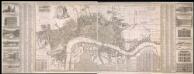
A New & Exact Plan of the Cities of London, & c.
Map of London with title along the top, arms of the 12 principal livery companies at top left with City arms and emblems of the arts. Lists of wards and parishes are reported in a table at bottom left and a descriptive note near bottom centre, with fares of coaches and ferries at bottom right. Down both sides of the map are views of prominent buildings: St Paul's Cathedral, the Banqueting House, the Royal Exchange, Custom House, the Admirably Office, the Royal Palace at St James', Westminster Abbey, Guildhall, the Bank of England, the Tower of London, the Treasury and South Sea House. Foster, George
LONDON 76
This small map of London and suburbs was included in a small 1707French travel book, "Les Delices de la Grande Bretagne". It features a compass rose at bottom right, and a title with reference panel below the plan. Bevereel, James
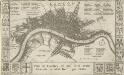
Plan of the City of LONDON before the Fire Anno Domini 1666.
This is a retrospective plan of the City of London before the great fire of 1666. Place names are indicated by an alphanumeric key.
London & c., accurately Surveyed, an accurate Plan of the Cities of London and Westminster and the Borough of Southwark, 1732
This is a later edition of the map of London first issued by Morden and Lea in 1681-82. Printed in 12 sheets, the map features title in banner along the top, portraits of King William and Queen Mary below the title, with the Royal and City arms. Reference tables, compass rose and scale bar at lower right. Along the top of the map are views of Westminster Abbey, the Banqueting Hall, Somerset House, the Mercers' Chapel, the Royal Exchange, Guild Hall and St Paul's Cathedral, with equestrian statues of Charles I and Charles II at top left and right respectively. The map shows Wigmore Street, Grosvenor Square and the Church of St Anne, Limehouse which did not feature in earlier editions of the map. Morden, Robert and Lea, Philip
A New & accurate PLAN of the CITIES of LONDON & WSTMINSTER & BOROUGH of SOUTHWARK
This is the sixth edition of a map first published in 1765. It includes views of London landmarks, such as St James's Palace and St Paul's Cathedral, and the arms of the 12 principal City Companies. Dicey was a map seller rather than a cartographer and much of his work is derivative or reissued from earlier plates. This map states that it is printed according to an "Act of Parliament". This makes reference to the Act passed in 1734 to curb the practice of unacknowledged copying. Thereafter, anyone who breached the new 14-yearcopyright period would have to hand over their derivative plates to the master of the original, paying 5 shillings for each offending print on the premises. Cluer Dicey
London &c., accurately surveyed by Wm Morgan, His Majesty Cosmographer
This is a later edition of the map of London and the built up area around it first issued by Morgan in 1681-82. The title of the map is missing. Also missing are the views of the equestrian statues of Charles I and II, prominent buildings and prospect of the City that accompanied the map. The map features scale bar and compass rose near bottom centre and reference tables with key to buildings in London, Westminster and Southwark along the bottom. Down the left is a list of officers of State and dignitaries and down the right is a list of City companies, Irish nobility and the clergy. Morgan, William
LONDINI ANGLIAE REGNI METROPOLIS 70
The title of this map of London, Westminster and Southwark appears along the top. Figures of cherubs are depicted at top left facing the reference table at top right. The royal and city arms are illustrated at the foot of the plate, with a key to places in Southwark and compass rose at lower left, facing the portraits of King William III and Queen Mary at bottom right. The panorama of the city which features in the panel below the plan is based on Matthaeus Merian’s view published in "Theatrum Europeum" in 1720. Joannes de Ram had already published an identical map of the city. His name was removed from the plan when French mapmaker, engraver and publisher Jacques de la Feuille married de Ram’s widow and took over his publishing business. Feuille, Jacques de la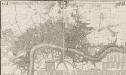
THIS ACTUAL SURVEY OF LONDON, WESTMINSTER & SOUTHWARK IS HUMBLY DEDICATED TO Ye LD MAYOR & COURT OF ALDERMEN
This map is a reissue of a 1690 plan. It features the title in a banner along the top with a compass rose and the city arms. The key to public offices, wards, parishes, halls and companies appear in tables at the bottom and lower right. Prominent buildings shown in elevation. This updated edition includes the Cavendish Square development, which began in 1717. Covens& Mortier was a successful publishing business, including in its output re-issues of general atlases by Jaillot, Delisle, Vichsscher and de Wit, whose stock they had acquired. Covens, Jean & Mortier, Corneille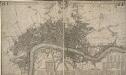
This Actuale Survey of LONDON, WESTMINSTER & SOUTHWARK IS HUMBLY DEDICATED TO Y.e L.D LORD MAYOR & COURT OF ALDERMEN
This later edition of Morden and Lea's 1688 map was published by Covens & Mortier in Amsterdam in 1725. The title appears in English and French in a ribbon along the top. The key to churches, city wards, palaces, halls and companies features in a reference table at the foot of the plate. Jean Covens and Corneil Mortier founded the prestigious printing and publishing house that bears their names in Amsterdam in 1721. Over the years they published wall maps of countries and continents, reissuing many maps, town plans and general atlases by the likes of De Wit, Jaillot and De Lisle. Their heirs continued the business until the 1880s. Morden, Robert & Lea, Philip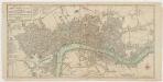
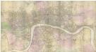
Bowles's new pocket plan of the cities of London & Westminster with the borough of Southwark : comprehending the new buidlings and other alterations to the year 1783
1 : 9800 Bowles, Carington, 1724-1793 Printed for the proprieter Carrington Bowles
PLAN of the Cities of LONDON and WESTMINSTER the Borough of SOUTHWARK and PARTS adjoining Shewing every HOUSE. By R. Horwood.
This magnificent map covers 32 sheets, each measuring 21" 5/8 x 19" 3/4. It was published sheet by sheet between 1792 and99 and was the work of several engravers under the direction of cartographer Richard Horwood. It is generally considered to be the most important London map of the 18th century. Horwood intended originally to show every house and its number but this was to prove impossible. Although every house is included the numbering was never completed. Horwood dedicated this map to the Trustees and Directors of the Phoenix Fire Office, reflecting that the protection of London from fire was at this time the reserve of numerous independent company brigades. The map is coloured, describing parks in green and the London Wall in red. The Tower of London is shown only by outline; Horwood records that: 'The Internal Parts not distinguished being refused permission to take the Survey’, evidence that a surveyor was not always welcome. Southwark was traditionally a district where the industries of brewing and tanning, unwelcome in the main city, were located. Barclay Perkins & Cos., which in the coming century was to become the largest brewery in the world, is marked on the map, as is Guy's Hospital ("for incurables") which at had recently been extended to include a new hospital for the psychiatrically disturbed. This map was reissued at least four times, with relevant additions and alterations, up until 1819. Horwood, Richard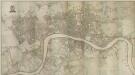
PLAN of the Cities of LONDON and WESTMINSTER the Borough of SOUTHWARK and PARTS adjoining Shewing every HOUSE. By R. Horwood
Map of London printed in 32 sheets and published sheet by sheet between 1792 and 1799, the work of several engravers working to the direction of the cartographer Richard Horwood. Horwood dedicated this map to the Trustees and Directors of the Phoenix Fire Office, reflecting that the protection of London from fire was at this time the reserve of numerous independent company brigades. This edition features a Phoenix at top left with the word "protection" emblazoned beneath it and is uncoloured in its entirety. The Tower of London is shown only by outline, as Horwood records that "The Internal Parts not distinguished being refused permission to take the Survey", testimony that a surveyor was not always welcome. Industries such as brewing and tanning, unwelcome in the city, are located south of the river in Southwark. Barclay Perkins & Co., the largest brewery in the world during the 1800s, is marked on the map, as is Guy's Hospital (for incurables). At the time of this map, the hospital had recently been extended to include a new ward for "lunatics". This map was re-issued, with additions and alterations, at least four times until 1819. Horwood, Richard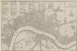
PLANES DES VILLES DE LONDRES ET DE WESTMINSTER et de leurs Faubourges, avec le Bourg de Southwark
The title of this French plan runs along the top of the sheet, with table of references at top left, facing the scale bar and compass rose at top right. This map was included in Nicolas de Fer's "Atlas Curieux". Fer, Nicholas de
A Plan of the Cities of London and Westminster, the Borough of Southwark, and the contiguous Buildings..
This map of London in eight sheets is enclosed by a decorative border and features title along the top, with scale bars, reference table and advertisement along the bottom. The advertisement states that the map is bases on Rocque's map of 1747, with the addition of all the new buildings, Westminster Bridge and the approach roads to the bridge. Rocque, John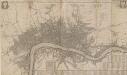
This Actuall Survey Of LONDON, WESTMINSTER AND SOUTHWARK Is humbly Dedicated To Y.e L.d M.Yor & Court Of Aldermen by R.o: Morden, Phil: Lea Chr: Browne
This is a later edition of a very popular map of London first published by Morden and Lea in 1690. The map's title features along the top, with the city arms at top left, facing the publisher's imprint in shield at top right. The reference tables, scale bar and compass rose appear at lower right. The plan marks the city's growth in the late Stuart period, showing its northward spread towards Islington. Morden, Robert & Lea, Philip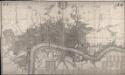
This Actual Survey Of London Westminster Southwark Is Humbly Dedicated To Ye Ld. Mayor & Court of Aldermen
Morden, Robert; Lea, Philip Covens et Mortier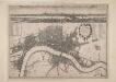
A New Map of the Cities of London and Westminster and Ye Borough of Southwarke with the Suburbs
Large map of London with prospect view of the City from Bankside in a strip above the main plan. Entitled "Prospect of London as it was flourishing before the destruction by fire", the view is based on Hollar's celebrated view of London from Bankside of 1647 and shows London from Worcester House (just west of the Savoy) on the west to Wapping and St Catherine's Docks to the east. The view shows London before the fire being composed almost exclusively of Gothic buildings, Inigo Jones’s Banqueting Hall at Whitehall and the classical restoration of St. Paul’s cathedral being the only examples of Renaissance architecture. The map, with title in cartouche, reference tables at top right and top left and scale bar at bottom centre, is a very minute bird's eye view of the cities of London and Westminster, the borough of Southwark and the suburbs showing London after the fire growing in area faster than ever before. Stepney Church, for example, marks a new point of growth east of the city. Hollar, Wenceslaus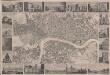
London
This is a "proof before letters", the trade term used for animpression withdrawn by the author before the title and imprint could be added for publication.The map covers London in the 1830s, and is surrounded by small pictorial views of prominent buildings and landmarks including East India House, Marble Arch, Westminster Abbey and Waterloo Bridge. Anonymous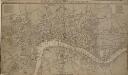
LONDON, WESTMINSTER AND SOUTHWARK, Accurately delineated from the latest Surveys,
John Cary was possibly the most productive maker and publisher of maps in England the 18 Century. His works were reissued many times, but unlike many of his contemporaries he aimed to update each new edition by including new developments. This is the second edition of a map originally published in 1782. The imprint and table of Hackney coach fares (referred to in the description) has been removed from the bottom of the map. Cary, John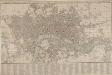
SMITH'S New Plan of LONDON, WESTMINSTER & SOUTHWARK: comprehending all the New Buildings and 350 References to the Principal Streets
First published by Smith in 1801, this popular map of London went into 27 editions, the last being issued in 1843. The title features along the top, with roads, open spaces, watercourses and the built-up area of the city delineated in colour. A reference table appears in the panel below the plan. Smith, Charles
A Mapp of the Cityies of LONDON & WESTMINSTER & BURROUGH of SOUTHWARK with their Suburbs and the Addition of the New Buildings
The title of this map of London, Westminster and Southwark appears along the top, with a reference table (flanked by sword and mace-bearer) at top left, a figure of Mercury (with the city arms on his shield) at top centre, and a second reference table below city arms at top right. The key to places in Southwark appear in a table at St. George's Fields, with compass star and scale bar at bottom centre and an allegorical figure of Father Thames at bottom right. John Oliver first issued this map in 1680.This is a later edition published and sold by John Bowles from his shop at the Black Horse in Cornhill. Oliver, John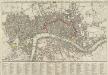
A new Pocket Plan of LONDON WESTMINSTER and SOUTHWARK, with all the Adjacent Buildings. Also a correct List of upwards of 300 Hackney Coach Fares 1797.
Pocket plans were made popular by publisher Thomas Bowles in the 1730s. This later map is coloured to highlight the old London Wall and the parks and open spaces. This map includes a list of Hackney Coach Fares. The development of turnpike roads from the 1750s onwards led to a steady increase of wheeled vehicles such as the Hackney Coach, which eventually made watermen redundant Darton, William and Harvey, Josiah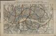
Reynolds's distance map of London, for ascertaining cab fares & shewing the distances in every direction from the railway stations &c.
James Reynolds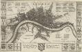
LONDON 45
This map is surveyed by Richard Blome, a heraldic writer and cartographer. Although prolific, he was something of a magpie, borrowing from many sources in the creation of his maps. Engraved by Hollar, this map is dedicated to Sir Robert Vyner, whose coat of arms is depicted at the bottom. The arms of the 12 Great City companies are drawn in the side margins. These companies were the trade guilds of London, many of which have existed from the middle ages to the present day. Hollar, Wenceslaus