Maps of Allegheny Plat.
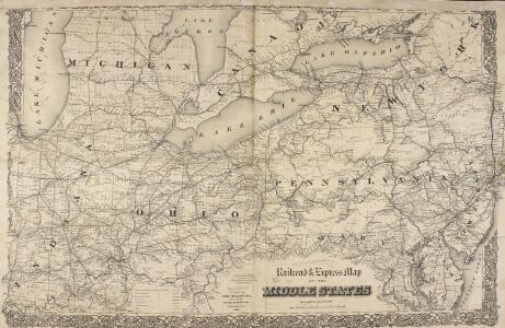
Railroad & Express Map of the Middle States
1 : 1267200 Railroad & Express Map of the Middle States. R. Blanchard.
Lehigh Valley line.
1 : 4754200 Lehigh Valley Railroad
A New Map Of The Seat Of War.
1 : 2534400 Lewis, Samuel
A General Map of the Middle British Colonies, in America.
1 : 2200000 Robert Sayer and John Bennett (Firm)
Map of the railroad lines in the Pennsylvania System
1 : 2200000 Annotatie: Met 2 aansluitende bijkrt. van Lake Michigan en Chesapeake Bay [S.l. : s.n.]
The State of Ohio, with part of Upper Canada, &c.
from Carey's general atlas, improved and enlarged : being a collection of maps of the world and quarters, their principal empires, kingdoms, &c.
Bowles's new pocket map of the following independent states of North America: viz. Virginia, Maryland, Delaware, Pensylvania, New Jersey, New York, Connecticut & Rhode Island: comprehending also the habitations & hunting countries of the confederate Indians / by Lewis Evans.
from Charts and maps Lewis Evans,
Maryland and Delaware. Ohio and Indiana.
1 : 2100000 Schonberg & Co.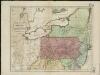
Map of the middle states of America, comprehends New-York, New-Jersey, Pennsylvania, Delaware, and the territory N.W. of Ohio
Russell, John Symonds, Henry Delahoy
Ohio.
1 : 1830000 Carey, Mathew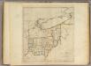
State of Ohio.
1 : 1750000 Carey, Mathew
Map of New Jersey and Pennsylvania : exhibiting the post offices, post roads, canals, rail roads, &c. / by David H. Burr (late topographer to the Post Office), geographer to the House of Representatives of the U.S.
from Parts
179. Center manufactures, population 1790-1900.
1 : 3900000 Gannett, Henry, 1846-1914
16. Center of population 1790-1900.
1 : 3900000 Gannett, Henry, 1846-1914
Virginia and Maryland / By H. Moll, geographer.
from Parts
New York, New Jersey, Pennsylvania, and Delaware.
1 : 3652000 Fisher, Richard Swainson
Map Pittsburgh & Western Railway Co.
1 : 5844000 Pittsburgh & Western Railway Company
County map of Ohio and Indiana.
from New general atlas.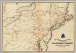
Lines and Metallic Circuit Connections.
1 : 2534400 American Telephone and Telegraph Company
A map of the province of Pensilvania / drawn from the best authorities, by T. Kitchin, gr.
from John H. Levine Collection
A correct map of Virginia.
from Carey's general atlas, improved and enlarged : being a collection of maps of the world and quarters, their principal empires, kingdoms, &c.
Ohio, Pennsylvania, New York, Maryland.
1 : 1584000 Smith, J. Calvin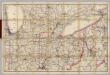
(Indiana, Ohio) Railroad Map of the United States.
1 : 506880 Rand McNally and Company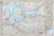
Shell Sectional Map No. 2 - North Atlantic States.
1 : 1457280 Shell Oil Company
The tourist's pocket map of Pennsylvania : exhibiting its internal improvements, roads, distances &c. / by J.H. Young ; D. Haines, sc.
from Whole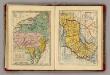
Middle & Southern States.
Goodrich, S.G.
Middle States.
1 : 3600000 Huntington, Nathaniel G. (Nathaniel Gilbert), 1785-1848
Bridge by which the South Mountain & Boston R.R. is to cross the Hudson River at Poughkeepsie, N.Y. ; The Map of South Mountain and Boston
from New illustrated atlas of Dutchess County, New York. / Compiled & drawn from personal examinations, surveys etc. under the personal supervision of O.W. Gray & Son and F.A. Davis, and published under the superintendence of H. L. Kochersperger.
A map of the canals & rail roads of Pennsylvania and New Jersey, and the adjoining states / by H.S. Tanner; engraved by H.S. Tanner & assistants.
from Parts Henry S. Tanner,