Maps of Coastal Plain

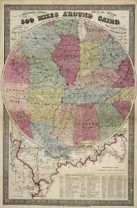
G.W. Colton's Map of the Country 500 miles around Cairo
G.W. Colton's Map of the Country 500 miles around Cairo, showing the Seat of War in the West, by G.W. Colton. This Colton map from 1862 showing 500 Miles around Cairo details the western seat of the war with Illinois at the centre point and shows both Union and Confederate States. The map helps to give a sense of scale to the war as it stretched across much of the country, particularly the eastern and middle states with the southern Illinois town of Cairo close to the tempestuous Border States of Kentucky and Missouri and the northern part of the Confederacy. The map also lists fortifications in the Western and Gulf states and the principal towns and cities along the Ohio and Mississippi Rivers.
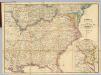
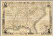
Phelps & Watson's Historical and Military Map of the Border and Southern States.
Phelps & Watson's Historical and Military Map of the Border and Southern States. This map, produced in New York in 1863 shows all the Confederate states, including a sizable amount of Texas, as well as the Border States of the Union. It is noteworthy that by this point in the war, Virginia has split into to, with the western half seceding from the rest of the state. West Virginia was admitted to the Union in 1863 and the map clearly shows the separation. The map also contains a list of the major battles from 1861 and 1862 in the bottom right hand corner.
Coal fields US.
1 : 3300000 Walker, Francis Amasa, 1840-1897
Map showing the connections of the Illinois Central Railroad with the railway lines to the Gulf ports / engraved by H.H. Lloyd & Co.
1 : 2300000 H. H. Lloyd & Co, New York, N.Y [S.l. : s.n.]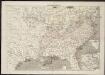
Frank Leslie's war maps
Leslie, Frank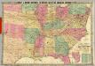
Historical And Military Map Of The Border & Southern States.
1 : 2534400 Phelps & Watson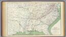
Colton's U.S. section.
1 : 3168000 United States. War Department
Les États Unis de l'Amérique septentrionale
1 : 6050000 Spojené státy americké-oblast západní Bonne, Rigobert André
Phelps's national map of the United States: a travellers guide: embracing the principal rail roads, canals, steam boat & stage routes, throughout the union / drawn & engraved by J.M. Atwood, New York; portraits & st. arms engd. by Wm. D. Smith.
from Whole J. M. Atwood; Phelps; William D. Smith,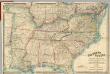
Map Of The Southern States of North America
1 : 2025000 Wyld, James, 1812-1887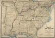
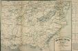
Map of the Southern States of North America, with the Forts, Harbours, and Military Positions
Map of the Southern States of North America, with the Forts, Harbours, and Military Positions. This map, published by Wyld in 1865, shows much of the Confederacy and the Border States as they were at the end of the Civil War. The divide between Virginia and West Virginia is marked, along with ‘forts, harbours & military positions’. The dark black lines indicated railway routes and it is notable how many more there are in the small segment of the Northern states displayed at the top of the map in comparison to the Confederate states. J. Wyld
The Historical War Map.
1 : 3294720 Russell, Benjamin B.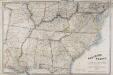
Map of the Southern States of North America, with the Forts, Harbours and Military Positions.
Map of the Southern States of North America, with the Forts, Harbours and Military Positions. Published by Wyld in 1862, Map of the Southern States of North America shows all the Confederate states, including the edge of Texas, and several of the Northern Border States too. Each state border is clearly defined. The map also labels ‘forts, harbours & military positions’, as well as marking the line between slave and free states, railways and canals. J. Wyld
United States Of North America.
1 : 1550000 Arrowsmith, Aaron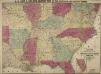
Lloyd's New Military Map of the Border and Southern States
Lloyd's New Military Map of the Border and Southern States. This map was published by H.H. Lloyd & Co. in 1862. The map shows mid America from the lower border of the Union to the eastern edge of Texas, thus showing all eleven Confederate states. Railway lines and fortifications are also labelled on the map.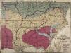
Lloyd's New Military Map of the Border and Southern States
Lloyd's New Military Map of the Border and Southern States. Lloyd’s New Military Map of the Border and Southern States from 1865 provides a clear example of the territory held by the Confederate and Union Armies at the end of the Civil War. The red parts indicated Confederate territory, now very much reduced compared to the other maps, the yellow parts show areas gained by the Union Army since early January 1862 and the blue part shows the route taken by General Sherman’s troops during their march through the South. The green indicates the Union. This map highlights how divided the Border States were with portions of Missouri and Kentucky coloured to indicate Union occupation. Although these both remained in the Union, internal civil struggles threatened to divide the states and Lincoln campaigned hard to ensure these states remained together. By comparison, Virginia witnesses an internal secession in 1863 and West Virginia can clearly be seen here on this map as part of the Union. This map is one of the best maps in the collection that detail how far the Union Army went into occupying the Confederate states and reuniting the country.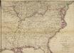
Woolley's new Map of the Seat of War in the Confederate States of America.
Woolley's new Map of the Seat of War in the Confederate States of America. Published in London, probably in 1861, Woolley’s New Map of the Seat of War in the Confederate States of America details the whole eastern half of the country. The red and green lines indicated which states held slaves and which states did not. The map shows all the Confederate states, excluding Texas, and shows how the Border States of Missouri and Kentucky were also slave-holding despite remaining part of the Union. H.G. Clarke & Co.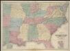
Map of the seat of war

Carte de la Louisiane, Maryland, Virginie, Caroline, Georgie, avec une partie de la Floride / C. Sepp. sculpsit.
from Charts and maps
Perrine's New Topographical War Map Of The Southern States.
1 : 2000000 Perrine, Charles O.
Die Staaten von Missouri, Illinois, Indiana, Ohio, Kentucky und Tennessee

Tourist through car line, Louisville & Nashville Railroad.
1 : 1900000 Louisville and Nashville Railroad Company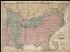
Lloyd's new military map of the border & southern states

Lloyd's new military map of the border & southern states
The Model War Map
The Model War Map, giving the Southern and Middle States, with all their Water and Railroad Connections. This map, published by Prang in 1862, shows the eastern coast condensed so that the focus is on the middle states of America from Iowa to Florida. The map shows railway routes, though it is noticeable how many stop before reaching the left hand side of the map, highlighting how railway building across the country was ongoing at the time of the Civil War. The tables on the right hand side of the map detail routes and distances from major cities and towns, 1860 population statistics, the slave population of slave-holding states and the number of men eligible to vote in each state.
Perrine's new topographical war map of the southern states, taken from the latest government surveys and official reports
1 : 2000000 Perrine, Charles O. Perrine, Charles O.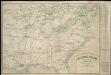
The model war map giving the southern & middle states, with all their water & railroad connections
Map Of The Southern States
1 : 3612000 Harper's Weekly
Map of the Seat of Civil War in America, September, 1862
Map of the Seat of Civil War in America, September, 1862. Produced by Davies & Co. in London, this map shows ten of the Confederate states, outlined in red, the Border States of Kentucky and Missouri, which remained within the Union, and lower portion of the Union states, outlined in green. The lower righter corner has an enlarged segment of the country detailing the sites of recent battles around lower Maryland, Washington, D.C. and Virginia. This includes Manassas Junction, where both battles of Bull Run had been fought prior to the map’s publication. Davies & Co.