Maps of Plaquemines Parish

Maps of Plaquemines Parish

$title$

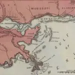
Lloyd's Military Campaign Charts: New Orleans - Mouth of Mississippi

Lloyd's Military Campaign Charts, showing the principal places of interest, compiled from official data by Gen. E.L. Viele and C. Haskins. Published under the auspices of the American Geographical and Statistical Society. New Orleans - Mouth of Mississippi.
$title$

Map of New Orleans and Adjacent Country.

1 : 696960 Melish, John
$title$

Map of New Orleans and Adjacent Country.

1 : 625000 Melish, John
$title$

Prang's Naval Expedition Maps: the Lower Mississippi, New Oreans, and vicinity

Prang's Naval Expedition Maps: the Lower Mississippi, New Oreans, and vicinity L. Prang & Co.
$title$

Map of New Orleans and Surrounding Country.

New York Herald
$title$

Breton Sound

1 : 250000
$title$

Breton Sound

1 : 250000
$title$

Breton Sound

1 : 250000
$title$

Breton Sound

1 : 250000
$title$

Mobile

1 : 250000
$title$

Mobile

1 : 250000
$title$

Mobile

1 : 250000
$title$

Mobile

1 : 250000
$title$

Mobile

1 : 250000
$title$

Mobile

1 : 250000
$title$

Mobile

1 : 250000
$title$

Mobile

1 : 250000
$title$

Mississippi River Delta

1 : 100000
$title$

Mississippi River Delta

1 : 100000
$title$

Black Bay

1 : 100000
$title$

Black Bay

1 : 100000
$title$

North Islands

1 : 100000
$title$

Gulfport

1 : 100000
$title$

Gulfport

1 : 100000
$title$

Biloxi

1 : 100000
$title$

Biloxi

1 : 100000
$title$

Downtown New Orleans. New Orleans and Vicinity.

Shell Oil Company
$title$

Lloyd's Military Campaign Charts: Mobile Bay

Lloyd's Military Campaign Charts, showing the principal places of interest, compiled from official data by Gen. E.L. Viele and C. Haskins. Published under the auspices of the American Geographical and Statistical Society. Mobile Bay.
$title$

Prang's Naval Expedition Maps: Mobile Harbor

Prang's Naval Expedition Maps: Mobile Harbor L. Prang & Co.
$title$

New Orleans and vicinity, Louisiana

1 : 24000 Geological Survey (U.S.) [Geological Survey]
© MapTiler © OpenStreetMap contributors
How does it work?
These instructions will show you how to find historical maps online.
Getting started
Type the place name in the search box to find the exact location. You can further adjust the search by zooming in and out.
Zoom
Zoom in and out with the buttons or use your mouse or touchpad natively.
Exact Area tool
Click here and draw a rectangle over the map to precisely define the search area.
Set filters
Narrow your search with advanced settings, such as Years (from/to), Fulltext, Publisher, etc.
Results
See the results of your search on the right side. You can scroll down to find more maps of this location.
?

Download OldMapsOnline Mobile