Maps of Gravesham
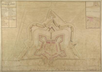
Plan of Tilbury Fort
Tilbury Fort was built in the late 17th century and replaced a smaller blockhouse built during the reign of Henry VIII. Tilbury Fort was built at a time when artillery was the main weapon and it was designed to take advantage of this. It was low lying and earthen to withstand the shock of bombardment. Large cannons were mounted along the river bank and a double line of moats protected the fort being attacked from the landward directions.
Essex (1st Ed/Rev 1862-96) LXXXIX.1 (includes: Gravesend; Thurrock) - 25 Inch Map
1 : 2500 Topographic maps Ordnance Survey Ordnance Survey
Essex (New Series 1913-) n XCV.12 (includes: Thurrock) - 25 Inch Map
1 : 2500 Topographic maps Ordnance Survey Ordnance Survey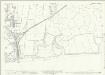
Essex (New Series 1913-) n XCV.12 (includes: Thurrock) - 25 Inch Map
1 : 2500 Topographic maps Ordnance Survey Ordnance Survey
TILLBURY FORT, GRAVESEND and Parts adjacent; with the PROPOSED WORKS coloured in yellow
Plan of Tilbury Fort in Essex situated on the northern bank of the River Thames. During his reign Charles II embarked on a plan to reorganise and improved the national defences. Sir Bernard de Gomme the Chief Engineer and Surveyor General of Ordnance, was in charge of the scheme and he designed the new fort at Tilbury. It was fashionable at the time for fortifications to be based on geometrical shapes and Tilbury fort was based on a rectangular pentagon. During the 18th century there were alterations to the fort and this plan is part of the proposals for the work that needed to be carried out. The large powder magazines were built and the barracks were reconstructed. Hyde Page, Thomas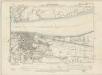
Essex LXXXIX.NW - OS Six-Inch Map
1 : 10560 Topographic maps Ordnance Survey Ordnance Survey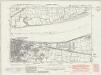
Kent X.NE - OS Six-Inch Map
1 : 10560 Topographic maps Ordnance Survey Ordnance Survey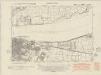
Kent X.NE - OS Six-Inch Map
1 : 10560 Topographic maps Ordnance Survey Ordnance Survey
Kent X.NE - OS Six-Inch Map
1 : 10560 Topographic maps Ordnance Survey Ordnance Survey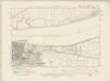
Kent X.NE - OS Six-Inch Map
1 : 10560 Topographic maps Ordnance Survey Ordnance Survey
Kent X.NE - OS Six-Inch Map
1 : 10560 Topographic maps Ordnance Survey Ordnance Survey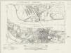
Essex nXCV.SE - OS Six-Inch Map
1 : 10560 Topographic maps Ordnance Survey Ordnance Survey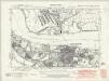
Essex nXCV.SE - OS Six-Inch Map
1 : 10560 Topographic maps Ordnance Survey Ordnance Survey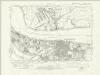
Essex nXCV.SE - OS Six-Inch Map
1 : 10560 Topographic maps Ordnance Survey Ordnance Survey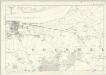
Essex LXXXIX - OS Six-Inch Map
1 : 10560 Topographic maps Ordnance Survey Ordnance Survey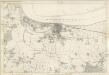
Kent X - OS Six-Inch Map
1 : 10560 Topographic maps Ordnance Survey Ordnance Survey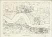
Essex nXCV - OS Six-Inch Map
1 : 10560 Topographic maps Ordnance Survey Ordnance Survey
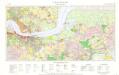
TQ67 - OS 1:25,000 Provisional Series Map
1 : 25000 Topographic maps Ordnance Survey Ordnance Survey
Rainham
1 : 21120 This is a roughly drawn field sketch of the north bank of the Thames, extending from West Thurrock, at the bottom, to Great Warley, at the top. The plan is made up of about 13 irregularly cut pieces of paper watermarked "1794". Some mismatch of detail is noticeable along the edges where the sheets have been joined, and the orientation of the lettering on the component parts is varied. Trigonometrical stations, from which the surveyors took angular readings, are marked 'flag', notably at 'Bulvan Fenn' and just above the low water mark for the Thames. Verron, Charles
East Tilbury, Essex
Great Britain [Second land utilisation survey] 1:25,000
Coleman, Alice Isle of Thanet Geographical Association
A topographical-map, of the county of Kent, 2
1 Blatt : 54 x 69 cm A. Dury, W. Herbert
Dartford (Hills) - OS One-Inch Revised New Series
1 : 63360 Topographic maps Ordnance Survey Ordnance Survey
Dartford (Outline) - OS One-Inch Revised New Series
1 : 63360 Topographic maps Ordnance Survey Ordnance Survey
Die Environs von London
Londýn (Anglie) Kitchin, Thomas Bowles, Carington
London passenger transport map
Ordnance Survey
[Kaart], uit: S.E. London & Sevenoaks
1 : 64000 titelvariant: Ordnance Survey contoured road map of S.E. London and Sevenoaks; Annotatie: Omslagtitel: Ordnance Survey contoured road map of S.E. London and Sevenoaks Ordnance Survey Southampton : The Director General, at the Ordnance Survey Office
Ordnance Survey of England and Wales (Sheet 7), South Wales
Ordnance Survey, Great Britain
Delineatio ac finitima regio Magnae Brittaniae metropoleos Londini
Londýn (Anglie) Seutter, Matthäus a Matt. Seutter