Maps of South West England
Lundy Island
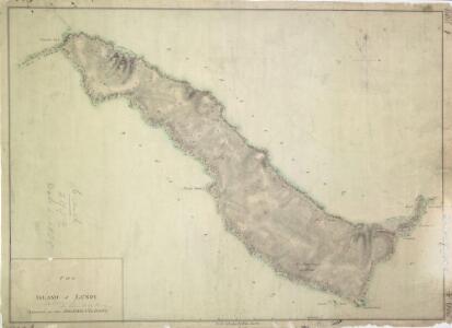
1 : 10560 This plan of Lundy Island, produced by Royal Military Surveyor and Draughtsman Thomas Compton, was found to be incorrect by Major General William Mudge. A letter from Mudge to General Morse, dated 7th January 1804,,questions the praise of Compton's ability made by his teacher, Charles Budgen. The Ordnance Survey Letter Book records a letter dated 4th January 1821, from Budgen to Colby, refuting the suggestion that he had produced the "erroneous" plan. In 1820 Lundy was surveyed anew by Lieutenant Alexander W Robe. Compton, Thomas
Devonshire IVa.NW & SW - OS Six-Inch Map
1 : 10560 Topographic maps Ordnance Survey Ordnance Survey
Plan Of Lundy Island
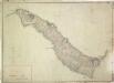
1 : 10560 A draughtsman's note in red ink, dated 28 April 1834, explains the corrections made to a small area of the west coast of the island, verifying the accuracy of the alterations made by Lieutenant Denham. Thomas Compton's original survey of the island made in 1804 was found to be incorrect, hence this revision. Robe, Alexander W
Devonshire IVa.NW - OS Six-Inch Map
1 : 10560 Topographic maps Ordnance Survey Ordnance Survey
Devonshire IVa.SW - OS Six-Inch Map
1 : 10560 Topographic maps Ordnance Survey Ordnance Survey
Devon IVA.2 (includes: Lundy Island) - 25 Inch Map
1 : 2500 Topographic maps Ordnance Survey Ordnance Survey
Devon IVA.2 (includes: Lundy Island) - 25 Inch Map
1 : 2500 Topographic maps Ordnance Survey Ordnance Survey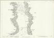
Devon IVA.6 (includes: Lundy Island) - 25 Inch Map
1 : 2500 Topographic maps Ordnance Survey Ordnance Survey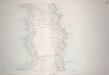
Devon IVA.6 (includes: Lundy Island) - 25 Inch Map
1 : 2500 Topographic maps Ordnance Survey Ordnance Survey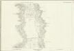
Devon IVA.6 (includes: Lundy Island) - 25 Inch Map
1 : 2500 Topographic maps Ordnance Survey Ordnance Survey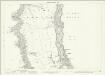
Devon IVA.10 (includes: Lundy Island) - 25 Inch Map
1 : 2500 Topographic maps Ordnance Survey Ordnance Survey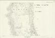
Devon IVA.10 (includes: Lundy Island) - 25 Inch Map
1 : 2500 Topographic maps Ordnance Survey Ordnance Survey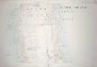
Devon IVA.10 (includes: Lundy Island) - 25 Inch Map
1 : 2500 Topographic maps Ordnance Survey Ordnance Survey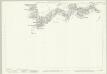
Devon IVA.14 (includes: Lundy Island) - 25 Inch Map
1 : 2500 Topographic maps Ordnance Survey Ordnance Survey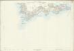
Devon IVA.14 (includes: Lundy Island) - 25 Inch Map
1 : 2500 Topographic maps Ordnance Survey Ordnance Survey
SS14 - OS 1:25,000 Provisional Series Map
1 : 25000 Topographic maps Ordnance Survey Ordnance Survey
Lundy Island (Outline) - OS One-Inch Revised New Series
1 : 63360 Topographic maps Ordnance Survey Ordnance Survey
Lundy Island (Outline) - OS One-Inch Revised New Series
1 : 63360 Topographic maps Ordnance Survey Ordnance Survey
Lundy Island (Hills) - OS One-Inch Revised New Series
1 : 63360 Topographic maps Ordnance Survey Ordnance Survey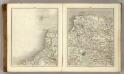
Sheets 11-12. (Cary's England, Wales, and Scotland).
1 : 360000 Cary, John, ca. 1754-1835
DEVONIAE COMOTAT
This map of Devon is by Christopher Saxton and dates from 1575. It forms part of an atlas that belonged to William Cecil Lord Burghley, Secretary of State to Elizabeth I. Burghley used this atlas to illustrate domestic matters. This map is actually a proof copy of one which forms part of Christopher Saxton’s Atlas of England and Wales. This atlas was first published as a whole in 1579. It consists of 35 coloured maps depicting the counties of England and Wales. The atlas is of great significance to British cartography as it set a standard of cartographic representation in Britain and the maps remained the basis for English county mapping, with few exceptions, until after 1750. During the reign of Elizabeth I map use became more common, with many government matters referring to increasingly accurate maps with consistent scales and symbols, made possible by advances in surveying techniques. This map was produced under the patronage of Thomas Seckford, a Master of Requests to Elizabeth I, who had commissioned Saxton’s atlas of county maps, a project overseen by Lord Burghley, Secretary of State, whose administration increasingly involved the use of maps. This map is interesting as there are several notes in the margins. In the lower right hand margin: 'A Note of hir maties Store of Ordonnaunce, powder and match, lead,&c.,remayningin ye L. Lieutenauntes, &c. hands'. In the upper right hand margin 'A Note what powder and match was appointed to be kept in store in every corporate towne'. In the left hand margin 'A Breef Note of ye places of Descent. . . yt are most daungerous and require greatest regard and assistaunce'. These annotations were most probably made by an assistant of Lord Burghley’s, and show the concern felt about coastal areas in the face of the threat from Spain which culminated in 1588 with the events of the Spanish Armada. Saxton, Christopher Hogenbergius, Remigius
A new map of the County of Devon
London : C. Smith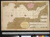
Het Canaal van Bristol of Severn of anders genaamt het Verkeerde Kanaal int grood
England Gerard van Keulen
Devoniae Descriptio. The Description of Devon-Shire [Karte], in: Novus atlas absolutissimus, Bd. 7, S. 199.
1 Karte aus Atlas Janssonius Offizin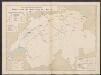
Devonia vulgo Devon-Shire. [Karte], in: Le théâtre du monde, ou, Nouvel atlas contenant les chartes et descriptions de tous les païs de la terre, Bd. 4, S. 120.
1 Karte aus Atlas Blaeu, Willem Janszoon und Blaeu, Joan Blaeu, Willem Janszoon
Devonia Vulgo Devon-Shire. [Karte], in: Theatrum orbis terrarum, sive, Atlas novus, Bd. 4, S. 136.
1 Karte aus Atlas Blaeu, Joan Blaeu, Willem Janszoon
Devonia Vulgo Devon-Shire. [Karte], in: Theatrum orbis terrarum, sive, Atlas novus, Bd. 4, S. 136.
1 Karte aus Atlas Blaeu, Joan Blaeu, Willem Janszoon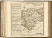

Sheet 10 England, South West, uit: Maps of England & Wales : scale 4 miles to 1 inch / Ordnance Survey
1 : 253440 titelvariant: Maps of England and Wales; Annotatie: Titel op cassette; Met bladoverzicht op de achterzijde van de cassette; Annotatie geografische gegevens: Hoogtelijneninterval 200 ft Ordnance Survey, United Kingdom Southampton : Ordnance Survey Office