Maps of Cornwall

Detail from OSD 2, Mounts Bay, Cornwall. Showing gun emplacements on St. Michael's Mount.
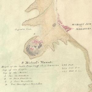
This detail is from the coastal survey showing the defence works of Mount's Bay, From Mousehole to Marazion., The area's status as a key defence point is shown by the large scale of the map: 6' To the mile., Positions and weights of cannons around the bay are noted, And the artillery on St Michael's Mount is described by a key.,Small crosses mark the positions of rocks in the bay. The,irregularly protruding,surfaces of Augusta Rock and Long Rock are indicated by intersecting lines of varying lengths, Differentiating these from the sand, Which is symbolised by dots. The condition of the,drawing is excellent. It is coloured with watercolour washes. , Find out more about the history of the Ordnance Surveyors Drawings in our,On the Trig ,Themed Tour. Hewitt, John
Cornwall LXXIV.4 (includes: Ludgvan; Marazion; Perranuthnoe; St Hilary; St Michaels Mount) - 25 Inch Map
1 : 2500 Topographic maps Ordnance Survey Ordnance Survey
Cornwall LXXIV.4 (includes: Ludgvan; Marazion; Perranuthnoe; St Hilary; St Michaels Mount) - 25 Inch Map
1 : 2500 Topographic maps Ordnance Survey Ordnance Survey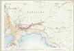
Cornwall LXXIV.4 (includes: Ludgvan; Marazion; Perranuthnoe; St Hilary; St Michaels Mount) - 25 Inch Map
1 : 2500 Topographic maps Ordnance Survey Ordnance Survey
Cornwall LXXIV.NE - OS Six-Inch Map
1 : 10560 Topographic maps Ordnance Survey Ordnance Survey
Cornwall LXXIV.NE - OS Six-Inch Map
1 : 10560 Topographic maps Ordnance Survey Ordnance Survey
Cornwall LXXIV.8 (includes: Perranuthnoe; St Michaels Mount) - 25 Inch Map
1 : 2500 Topographic maps Ordnance Survey Ordnance Survey
Cornwall LXXIV.8 (includes: Perranuthnoe; St Michaels Mount) - 25 Inch Map
1 : 2500 Topographic maps Ordnance Survey Ordnance Survey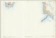
Cornwall LXXIV.8 (includes: Perranuthnoe; St Michaels Mount) - 25 Inch Map
1 : 2500 Topographic maps Ordnance Survey Ordnance Survey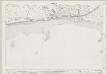
Cornwall LXXIV.3 (includes: Ludgvan) - 25 Inch Map
1 : 2500 Topographic maps Ordnance Survey Ordnance Survey
Cornwall LXXIV.3 (includes: Ludgvan) - 25 Inch Map
1 : 2500 Topographic maps Ordnance Survey Ordnance Survey
Cornwall LXXIV.3 (includes: Ludgvan) - 25 Inch Map
1 : 2500 Topographic maps Ordnance Survey Ordnance Survey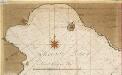
De rivier van Foweij en Mountsbaij int Canaal [Mountsbay]
England Gerard van Keulen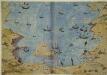
Mount's Bay, Cornwall
This plan shows Mount’s Bay in Cornwall in an invasion scenario and is thought to date from around 1540. It is orientated with south to the top, Penzance is lower right and St Michael’s Mount is in the centre. Lines extend between St Michael’s Mount and the mainland with distances expressed in words. Details of the landscape are shown pictorially, a feature typical of maps and plans of the Tudor period. Although the houses and churches of the area are depicted generically, the draughtsman has differentiated between those in good condition and those that have fallen into disrepair. Churches, with their towers and steeples, could be used as vantage points for surveillance, hence their prominent depiction here. The building shown here on St Michael’s Mount was home to a Benedictine monastery until the dissolution of the monasteries, after which it was fortified in order to take advantage of its excellent defensive location. The previous function of the building is clear from the crosses which decorate the apex of the gable ends of the central building. The existence of this drawing can be imputed to the threat of invasion which became probable in 1538 after a peace treaty was signed by Francis I of France and Charles V, Holy Roman Emperor and King of Spain. England and France were ancient enemies and the Catholic Charles V, nephew of Catherine of Aragon, was angered by Henry VIII’s decision to divorce her. Henry’s dissolution of the monasteries provided him with enormous wealth with which he was able to commission surveys of the vulnerable coastline and build defence fortifications. It is likely that this drawing was executed in order to illustrate defence strategies feared to be necessary in this climate of unease.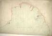
Lands End, Mount's Bay, Cornwall
This coastal survey shows the defence works of Mount's Bay, from Mousehole to Marazion. The area's status as a key defence point is shown by the large scale of the map: 6' to the mile. Positions and weights of cannons around the bay are noted, and the artillery on St Michael's Mount is described by a key. Small crosses mark the positions of rocks in the bay. The irregularly protruding surfaces of Augusta Rock and Long Rock are indicated by intersecting lines of varying lengths, differentiating these from the sand, which is symbolised by dots. The condition of this drawing is excellent. It is coloured with watercolour washes. Hewitt, John
Penzance (Hills) - OS One-Inch Revised New Series
1 : 63360 Topographic maps Ordnance Survey Ordnance Survey
Penzance (Outline) - OS One-Inch Revised New Series
1 : 63360 Topographic maps Ordnance Survey Ordnance Survey
Land's End, Cornwall
On this plan of a section of the English south coast, tin and copper mines ('wheals') are indicated by lines of dots arranged in blocks. To the left of Sancred, the ancient fort of Caer Bran is denoted by a circular marking, even though systematic recording of archaeological sites did not become obligatory until 1816. The drawing is considerably worn around the edges, rendering the cartographic detail almost illegible. Long Ships lighthouse is faintly discernible. Colour washes have faded and margins have been trimmed. Hewitt, John
Lands End - OS One-Inch Map
1 : 63360 Topographic maps Ordnance Survey Ordnance Survey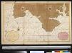
Een gedeelte van het Kanaal van de rivier van Falmouth tot aen Engelands Eijnde
England Gerard van Keulen
Cornwall, Sheet 37 - Bartholomew's "Half Inch to the Mile Maps" of England & Wales
1 : 126720 Topographic maps Bartholomew, John George John Bartholomew & Co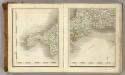
Sheets 1-2. (Cary's England, Wales, and Scotland).
1 : 360000 Cary, John, ca. 1754-1835
Cornvbia sive Cornwallia
1 Karte : Kupferdruck ; 38 x 48 cm Blaeu Joan Blaeu
South west coast of England from Exeter to Land's End, 1539-40
This is a map of the south-west coast of England, from Exeter to Land’s End. It dates from 1539-40 and its creation can be imputed to the threat of invasion which became probable in 1538 after a peace treaty was signed by Francis I of France and Charles V, Holy Roman Emperor and King of Spain. England and France were ancient enemies and the Catholic Charles V, nephew of Catherine of Aragon, was angered by Henry VIII’s decision to divorce her. Henry’s dissolution of the monasteries provided him with enormous wealth with which he was able to commission surveys of the vulnerable coastline and build defence fortifications. This map is the result of the order sent out by Thomas Cromwell in 1539 for the coasts to be surveyed by local people. These surveys, which were often just sketches or even text, were sent to London and in Greenwich they were edited, compiled and copied out for presentation to the King, who displayed them in Whitehall. The style of the map is pictorial with details such as ships, town views and fortifications shown in accurate detail. However, it contains vital practical information such as the state of defences and the distance between points along the coast and measurements at sea. Measurements at sea appear to be the estimated distance at which the navigator could discern features of the coastline. These are given in Dutch kennings probably due to the fact that the draftsmen in Greenwich included Flemish artists. The purpose of the map was to indicates, as if from the viewpoint of an invader, where landings could be made. Therefore, the cliffs, where landings would have been impossible are foreshortened, while the sandy beaches, where landings would have been easy are exaggerated in size. The sites for possible forts were then added to the map. The annotations on this map were made in about 1541 and record the state of fortifications, annotating made’ or not made’ over several fortification and half made’ over St Mawes Castle. Although this map contains measurements for use by sailors it is very unlikely that it would ever have been used at sea as it is almost 10 feet long and thus highly impractical for use within the confined space onboard ship. Thomas Cromwell
Cornubia sive Cornwallia
1 : 170000 Amstelodami : excudebat Ioannes Ianssonius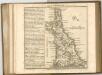

CORNVBIA | sive | CORNWALLIA.
[Amsterdam : Joan Blaeu]
PROMONTORIUM HOC IN MARE PROYECTUM CORNUBIA DICITUR Sheet 5
This map of Cornwall is from the 1583 edition of the Saxton atlas of England and Wales.This atlas was first published as a whole in 1579. It consists of 35 coloured maps depicting the counties of England and Wales. The atlas is of great significance to British cartography as it set a standard of cartographic representation in Britain and the maps remained the basis for English county mapping, with few exceptions, until after 1750. During the reign of Elizabeth I map use became more common, with many government matters referring to increasingly accurate maps with consistent scales and symbols, made possible by advances in surveying techniques. Illustrating the increasing used of maps in government matters, Lord Burghley, Elizabeth I’s Secretary of State, who had been determined to have England and Wales mapped in detail from the 1550s, selected the cartographer Christopher Saxton to produce a detailed and consistent survey of the country. The financier of the project was Thomas Seckford Master of Requests at the Court of Elizabeth I, whose arms appear, along with the royal crest, on each map. Saxton, Christopher Ryther, Augustine
PROMONTORIUM HOC IN MARE PROYECTUM CORNUBIA DICITUR f.8
This map of Cornwall is by Christopher Saxton. It forms part of an atlas that belonged to William Cecil Lord Burghley, Elizabeth I’s Secretary of State. Burghley used this atlas to illustrate domestic matters. This map is actually a proof copy of one which forms part of Christopher Saxton’s Atlas of England and Wales. This atlas was first published as a whole in 1579. It consists of 35 coloured maps depicting the counties of England and Wales. The atlas is of great significance to British cartography as it set a standard of cartographic representation in Britain and the maps remained the basis for English county mapping, with few exceptions, until after 1750. During the reign of Elizabeth I, map use became more common, with many government matters referring to increasingly accurate maps with consistent scales and symbols, made possible by advances in surveying techniques. This map was produced under the patronage of Thomas Seckford, a Master of Requests to Elizabeth I, who had commissioned Saxton’s atlas of county maps, a project overseen by Lord Burghley, Secretary of State, whose administration increasingly involved the use of maps. Here an annotation, probably by Lord Burghley, can be seen in the addition of a bridge at Truro. Such an addition is typical of Lord Burghley who was concerned with communication routes, such as roads and bridges, which were vital to the defence of the country, a central consideration during the reign of Elizabeth I, during which England was continually under threat. Saxton, Christopher Antver, Lenaert Terwoort