Maps of Northumberland

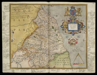
NORTHUMBRIAE COMITATUS
This is a map of Northumberland by Christopher Saxton dating from the 1570's. It forms part of an atlas that belonged to William Cecil Lord Burghley, Elizabeth I’s Secretary of State. Burghley used this atlas to illustrate domestic matters. This map is actually a proof copy of one which forms part of Christopher Saxton’s Atlas of England and Wales. This atlas was first published as a whole in 1579. It consists of 35 coloured maps depicting the counties of England and Wales. The atlas is of great significance to British cartography as it set a standard of cartographic representation in Britain and the maps remained the basis for English county mapping, with few exceptions, until after 1750. During the reign of Elizabeth I map use became more common, with many government matters referring to increasingly accurate maps with consistent scales and symbols, made possible by advances in surveying techniques. Illustrating the increasing use of maps in government matters, Lord Burghley, who had been determined to have England and Wales mapped in detail from the 1550s, selected the cartographer Christopher Saxton to produce a detailed and consistent survey of the country. The financier of the project was Thomas Seckford, Master of Requests at the Court of Elizabeth I, whose arms appear, along with the royal crest, on each map. Burghley has annotated this map, adding several place names along the Anglo-Scottish border. On three margins of the map, Burghley has annotated the Names of ye principall lorsh[ips] in ye Middle march [&c.] and the Lordes names. The map was engraved one of a team of seven English and Flemish engravers employed to produce the copper plates for the atlas, but the individuals name is not included. Saxton, Christopher William Cecil, Lord Burghley
NORTHIMBRIAE COMITATUS
This map of Northumbria is from the 1583 edition of the Saxton atlas of England and Wales.This atlas was first published as a whole in 1579. It consists of 35 coloured maps depicting the counties of England and Wales. The atlas is of great significance to British cartography as it set a standard of cartographic representation in Britain and the maps remained the basis for English county mapping, with few exceptions, until after 1750. During the reign of Elizabeth I map use became more common, with many government matters referring to increasingly accurate maps with consistent scales and symbols, made possible by advances in surveying techniques. Illustrating the increasing used of maps in government matters, Lord Burghley, Elizabeth I’s Secretary of State, who had been determined to have England and Wales mapped in detail from the 1550s, selected the cartographer Christopher Saxton to produce a detailed and consistent survey of the country. The financier of the project was Thomas Seckford Master of Requests at the Court of Elizabeth I, whose arms appear, along with the royal crest, on each map. Saxton, Christopher Ryther, Augustine
Comitatus Northumbria Vernacule Northumberland. [Karte], in: Theatrum orbis terrarum, sive, Atlas novus, Bd. 4, S. 505.
1 Karte aus Atlas Blaeu, Joan Blaeu, Willem Janszoon
Comitatus Northumbria; Vernacule Northumberland. [Karte], in: Le théâtre du monde, ou, Nouvel atlas contenant les chartes et descriptions de tous les païs de la terre, Bd. 4, S. 431.
1 Karte aus Atlas Blaeu, Willem Janszoon und Blaeu, Joan Blaeu, Willem Janszoon
Comitatus Northumbria Vernacule Northumberland. [Karte], in: Theatrum orbis terrarum, sive, Atlas novus, Bd. 4, S. 505.
1 Karte aus Atlas Blaeu, Joan Blaeu, Willem Janszoon
Comitatus Northumbria vernacule Northumberland. [Karte], in: Novus atlas absolutissimus, Bd. 8, S. 89.
1 Karte aus Atlas Janssonius Offizin
COMITATVS | NORTHVMBRIA; | Vernacule | NORTHUMBERLAND.
Ioh. Blaeu Exc.
Comitatus Northumbria vernacule Northumberland
1 : 300000 Amstelodami : apud Joannem Janssonium
Sheet 1 The Border, uit: Maps of England & Wales : scale 4 miles to 1 inch / Ordnance Survey
1 : 253440 titelvariant: Maps of England and Wales; Annotatie: Titel op cassette; Met bladoverzicht op de achterzijde van de cassette; Annotatie geografische gegevens: Hoogtelijneninterval 200 ft Ordnance Survey, United Kingdom Southampton : Ordnance Survey Office
Scotland / J. Ainslie, 9
1 Blatt : 67 x 58 cm Ainslie, Faden
England and Wales 1:253,440
Ordnance Survey
Northumbria, Cumberlandia, et Dunelmensis Episcopatus
1 : 396000
Comitatvs Northvmbria; vernacula Northvmberland
1 Karte : Kupferdruck ; 39 x 48 cm Blaeu Joan Blaeu

A new improved map of Northumberland
1 Karte : Kupferdruck ; 67 x 50 cm Kitchin; Hinton sold by J. Hinton at the Kings Arms in St. Pauls Church Yard
Holy-Island, Fairn Islands with the many Rocks and Hazards that lye Scatter'd in that Sea, and the Coast from Sunderland point in England to St Abbs-head in Scotland, survey'd and navigated by J[oh]n
Adair, John, ca. 1650-1722
Sheets 68-69. (Cary's England, Wales, and Scotland).
1 : 360000 Cary, John, ca. 1754-1835
Northumberland, South, Sheet 2 - Bartholomew's "Half Inch to the Mile Maps" of England & Wales
1 : 126720 Topographic maps Bartholomew, John George John Bartholomew & Co
Northumberland, North, Sheet 1 - Bartholomew's "Half Inch to the Mile Maps" of England & Wales
1 : 126720 Topographic maps Bartholomew, John George John Bartholomew & Co
TEVIOTIA | Vulgo | TIVEDAIL
[Amsterdam : Joan Blaeu]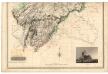
Roxburghshire.
Thomson, John, 1777- ca. 1840 Crawford, William & Son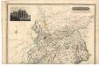
Roxburghshire.
Thomson, John, 1777- ca. 1840 Crawford, William & Son
A map of Roxburghshire or Tiviotdale.
Stobie, Matthew, fl. 1758-1807
A map of Roxburghshire or Tiviotdale.
Stobie, Matthew, fl. 1758-1807
Map of the County of Roxburgh.
Tennant, N., fl. 1835-1850
A map of Roxburghshire or Tiviotdale.
Stobie, Matthew, fl. 1758-1807
A map of Roxburghshire or Tiviotdale.
Stobie, Matthew, fl. 1758-1807
Cheviots - Bartholomew's 'Survey Atlas of Scotland'
1 : 126720 Topographic maps John Bartholomew & Son, Ltd John Bartholomew & Son, Ltd
Teviotia vulgo Tivedail
1 Karte : Kupferdruck ; 41 x 52 cm Blaeu; Pont Joan Blaeu
Map embracing extensive portions of the Counties of Roxburgh, Berwick, Selkirk & Midlothian and Part of Northumberland. Minutely & accurately surveyed... by Crawford and Brooke
Crawford, William, 1793-ca.1845 Brooke, William, fl. 1835-47.
Map embracing extensive portions of the Counties of Roxburgh, Berwick, Selkirk & Midlothian and Part of Northumberland. Minutely & accurately surveyed... by Crawford and Brooke
Crawford, William, 1793-ca.1845 Brooke, William, fl. 1835-47.
Map embracing extensive portions of the Counties of Roxburgh, Berwick, Selkirk & Midlothian and Part of Northumberland. Minutely & accurately surveyed... by Crawford and Brooke
Crawford, William, 1793-ca.1845 Brooke, William, fl. 1835-47.
Map embracing extensive portions of the Counties of Roxburgh, Berwick, Selkirk & Midlothian and Part of Northumberland. Minutely & accurately surveyed... by Crawford and Brooke
Crawford, William, 1793-ca.1845 Brooke, William, fl. 1835-47.
Map embracing extensive portions of the Counties of Roxburgh, Berwick, Selkirk & Midlothian and Part of Northumberland. Minutely & accurately surveyed... by Crawford and Brooke
Crawford, William, 1793-ca.1845 Brooke, William, fl. 1835-47.
Map embracing extensive portions of the Counties of Roxburgh, Berwick, Selkirk & Midlothian and Part of Northumberland. Minutely & accurately surveyed... by Crawford and Brooke
Crawford, William, 1793-ca.1845 Brooke, William, fl. 1835-47.
Map embracing extensive portions of the Counties of Roxburgh, Berwick, Selkirk & Midlothian and Part of Northumberland. Minutely & accurately surveyed... by Crawford and Brooke
Crawford, William, 1793-ca.1845 Brooke, William, fl. 1835-47.
Map embracing extensive portions of the Counties of Roxburgh, Berwick, Selkirk & Midlothian and Part of Northumberland. Minutely & accurately surveyed... by Crawford and Brooke
Crawford, William, 1793-ca.1845 Brooke, William, fl. 1835-47.