Maps of Norfolk
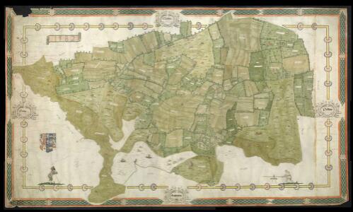
Estate Map of Smallburgh, Norfolk
This is a map of the parish of Smallburgh in Norfolk. It dates from 1582 and is the work of John Darby, who was active as a map maker between 1582 and 1594. It is significant as it is one of the first English local maps to be drawn to a consistent scale. It is in unusually good condition which is probably due to it never having been displayed because of its unfinished status, there is no title, several field name panels are left blank and some decoration is only in pencil. In addition to these omissions there is no numerical or alphabetical key to the terrier, the written register of plots, that with the information it contained of acreage’s, tenants and leases, would have been indispensable for the practical management of the estate. The map was made for Edward Park, 10th Lord of Morley, who had only regained his lands in 1578, some four years prior to the creation of this map. The lands had been confiscated from his father the 9th Baron Morley, a Catholic accused of treason in 1572. It is likely that the map was intended as a celebration of Lord Morely’s regained possession of the lands and that it would have been, if finished, displayed as a proclamation of his wealth and triumph in the face of adversity. The decorative qualities of the map can thus be explained. It includes an unusual wealth of animals, people and country pursuits. It is not unusual for scenes of this nature to be included as a tradition for including images of seasonal rural activities exists in maps and manuscripts, such as the Luttrell Psalter. What is unusual however is that rather than depicting seasonal activities, this map depicts scenes that are specific to the fenland area that is mapped. The figure of the traveller with a monkey on his shoulder could be an allusion to Lord Morley’s father who, having been evicted from his lands, spent the remainder of his life wandering the Continent, being recorded in Valenciennes, Brussels and Bruges in 1570. These decorative details show how maps could be highly personal articles with hidden meanings as well as practical tools for land administration. This map was annotated in 1762 to record minor changes in the shape of the plots of land and the course of the stream that runs through the parish, showing that it was used as a functional record, even almost 200 years after its creation Darby, John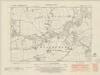
Norfolk XL.NE - OS Six-Inch Map
1 : 10560 Topographic maps Ordnance Survey Ordnance Survey
Norfolk XL.NE - OS Six-Inch Map
1 : 10560 Topographic maps Ordnance Survey Ordnance Survey
Norfolk XL.NE - OS Six-Inch Map
1 : 10560 Topographic maps Ordnance Survey Ordnance Survey
Norfolk XL.8 (includes: Barton Turf; Dilham; Smallburgh; Stalham) - 25 Inch Map
1 : 2500 Topographic maps Ordnance Survey Ordnance Survey
Norfolk XL.7 (includes: Dilham; Smallburgh; Tunstead; Worstead) - 25 Inch Map
1 : 2500 Topographic maps Ordnance Survey Ordnance Survey
Norfolk XL.4 (includes: Brumstead; Dilham; East Ruston; Smallburgh; Stalham) - 25 Inch Map
1 : 2500 Topographic maps Ordnance Survey Ordnance Survey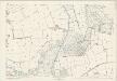
Norfolk XL.4 (includes: Brumstead; Dilham; East Ruston; Smallburgh; Stalham) - 25 Inch Map
1 : 2500 Topographic maps Ordnance Survey Ordnance Survey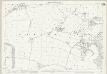
Norfolk XL.12 (includes: Ashmanhaugh; Barton Turf; Smallburgh) - 25 Inch Map
1 : 2500 Topographic maps Ordnance Survey Ordnance Survey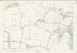
Norfolk XL.12 (includes: Ashmanhaugh; Barton Turf; Smallburgh) - 25 Inch Map
1 : 2500 Topographic maps Ordnance Survey Ordnance Survey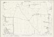
Norfolk XL.3 (includes: Dilham; Smallburgh; Worstead) - 25 Inch Map
1 : 2500 Topographic maps Ordnance Survey Ordnance Survey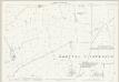
Norfolk XL.11 (includes: Ashmanhaugh; Barton Turf; Smallburgh; Tunstead) - 25 Inch Map
1 : 2500 Topographic maps Ordnance Survey Ordnance Survey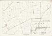
Norfolk XL.11 (includes: Ashmanhaugh; Barton Turf; Smallburgh; Tunstead) - 25 Inch Map
1 : 2500 Topographic maps Ordnance Survey Ordnance Survey
TG32 - OS 1:25,000 Provisional Series Map
1 : 25000 Topographic maps Ordnance Survey Ordnance Survey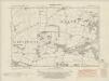
Norfolk XL.SE - OS Six-Inch Map
1 : 10560 Topographic maps Ordnance Survey Ordnance Survey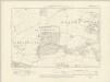
Norfolk XL.SE - OS Six-Inch Map
1 : 10560 Topographic maps Ordnance Survey Ordnance Survey
Norfolk XL.SE - OS Six-Inch Map
1 : 10560 Topographic maps Ordnance Survey Ordnance Survey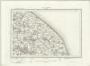
North Walsham (Outline) - OS One-Inch Revised New Series
1 : 63360 Topographic maps Ordnance Survey Ordnance Survey
North Walsham (Hills) - OS One-Inch Revised New Series
1 : 63360 Topographic maps Ordnance Survey Ordnance Survey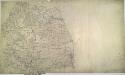
Yarmouth 23
1 : 31680 This drawing shows the coast of Great Yarmouth in detail. A fort and military batteries are indicated along the coast, reflecting the military emphasis of the survey. Nelson's monument in Great Yarmouth is illustrated. Nelson landed here on his return from the victory at the Battle of Copenhagen. In the bottom-right corner of this drawing a note reads: "Mr Budgen says the hills represented in this plan are extremely low and therefore they must be kept very light in the engraving T.C. [Thomas Colby]." Also: "Strumpshaw Hill in the south west corner of this plan is commonly considered upon the highest eminence in this county. I think it is not by a hundred feet or more and would judge Strumpshaw Hill to be upon an elevation of 250 feet above the level of the sea hall May 5 1817." Area measurements are also noted. Budgen, Charles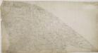
Cromer
1 : 31680 This plan records the Norfolk coastline, famous for its remote and diverse landscape. Sweeping sandy beaches, grass-tufted dunes and tidal inlets are all depicted. Light pencil interlinings ('hachures') are used to represent the gently rolling chalkland and glacial moraines leading away from the coast. Budgen, Charles
Norwich - OS One-Inch Map
1 : 63360 Topographic maps Ordnance Survey Ordnance Survey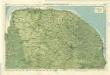
Norfolk, Sheet 15 - Bartholomew's "Half Inch to the Mile Maps" of England & Wales
1 : 126720 Topographic maps Bartholomew, John George John Bartholomew & Co
Sheets 44-45. (Cary's England, Wales, and Scotland).
1 : 360000 Cary, John, ca. 1754-1835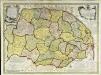
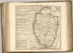
An accurate map of the county of Norfolk
1 Karte : Kupferdruck ; 52 x 70 cm Bowen; Hinton sold by I. Hinton at the Kings Arms in St. Pauls Church yard
Nortfolcia; vernacule Norfolke
1 Karte : Kupferdruck ; 36 x 47 cm Valck; Schenk penes Gerardum Valk et Petrum Schenk
Nortfolcia
1 Karte : Kupferdruck ; 37 x 48 cm Blaeu Joan Blaeu
Suffolcia. Vernacule Suffolke. [Karte], in: Theatrum orbis terrarum, sive, Atlas novus, Bd. 4, S. 285.
1 Karte aus Atlas Blaeu, Joan Blaeu, Willem Janszoon