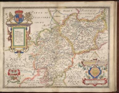
Maps of Warwickshire

WARWIC LECESTRIAE Comitat
This map of Warwickshire and Leicestershireis from the 1583 edition of the Saxton atlas of England and Wales. This atlas was first published as a whole in 1579. It consists of 35 coloured maps depicting the counties of England and Wales. The atlas is of great significance to British cartography as it set a standard of cartographic representation in Britain and the maps remained the basis for English county mapping, with few exceptions, until after 1750. During the reign of Elizabeth I map use became more common, with many government matters referring to increasingly accurate maps with consistent scales and symbols, made possible by advances in surveying techniques. Illustrating the increasing used of maps in government matters, Lord Burghley, Elizabeth I’s Secretary of State, who had been determined to have England and Wales mapped in detail from the 1550s, selected the cartographer Christopher Saxton to produce a detailed and consistent survey of the country. The financier of the project was Thomas Seckford Master of Requests at the Court of Elizabeth I, whose arms appear, along with the royal crest, on each map. Saxton’s name appears in the decorative scale bar, as does the name of the engraver of this map, Leonardus Terwoordus, one of a team of seven Flemish and continentally trained English engravers employed to work on the atlas. Relief, in the form of uniform rounded representations of hills, is the main topographical feature presented in the maps. Rather than provide a scientific representation of relative relief these give a general impression of the lie of the land. Settlements and notable buildings are also recorded pictorially; a small building with a spire represents a village, while more important towns, such as Leicester are indicated by groups of building. Rivers, streams, parks and woodlands are also depicted carefully. Woods are shown by small tree-symbols, with clusters representing forests, and parklands enclosed with ring fences. Saxton, Christopher Ryther, Augustine
WARWIC LECESTRIAQUE Comitat.
This is a map of Warwickshire and Leicestershire by Christopher Saxton dating from 1576. It forms part of an atlas that belonged to William Cecil Lord Burghley, Elizabeth I’s Secretary of State. Burghley used this atlas to illustrate domestic matters. This map is actually a proof copy of one which forms part of Christopher Saxton’s Atlas of England and Wales. This atlas was first published as a whole in 1579. It consists of 35 coloured maps depicting the counties of England and Wales. The atlas is of great significance to British cartography as it set a standard of cartographic representation in Britain and the maps remained the basis for English county mapping, with few exceptions, until after 1750. During the reign of Elizabeth I, map use became more common, with many government matters referring to increasingly accurate maps with consistent scales and symbols, made possible by advances in surveying techniques. Illustrating the increasing use of maps in government matters, Lord Burghley, who had been determined to have England and Wales mapped in detail from the 1550s, selected the cartographer Christopher Saxton to produce a detailed and consistent survey of the country. The financier of the project was Thomas Seckford Master of Requests at the Court of Elizabeth I, whose arms appear, along with the royal crest, on each map. The map was engraved by Leonardus Terwoordus , one of a team of seven English and Flemish engravers employed to produced the copper plates for the atlas. Saxton, Christopher Terwoordus, Leonardus Anterpianus
Wigorniensis Comitatus et Comitatus Warwicensis; nec non Coventrae Libertas. Worcester, Warwik Shire. and The Liberty of Coventre. [Karte], in: Theatrum orbis terrarum, sive, Atlas novus, Bd. 4, S. 356.
1 Karte aus Atlas Blaeu, Joan Blaeu, Willem Janszoon
Wigorniensis Comitatus et Comitatus Warwicensis; nec non Coventrae Libertas. Worcester, Warwik Shire, and The Liberty Of Coventre. [Karte], in: Le théâtre du monde, ou, Nouvel atlas contenant les chartes et descriptions de tous les païs de la terre, Bd. 4, S. 308.
1 Karte aus Atlas Blaeu, Willem Janszoon und Blaeu, Joan Blaeu, Willem Janszoon
Wigorniensis Comitatus et Comitatus Warwicensis; nec non Coventrae Libertas. Worcester, Warwik Shire. and The Liberty of Coventre. [Karte], in: Theatrum orbis terrarum, sive, Atlas novus, Bd. 4, S. 356.
1 Karte aus Atlas Blaeu, Joan Blaeu, Willem Janszoon
WIGORNIENSIS | Comitatus et Comitatus | WARWICENSIS| nec non | COVENTRÆ LIBERTAS | WORCESTER, WARWIK SHIRE. | and THE LIBERTY OF COVENTRE.
[Amsterdam : Joan Blaeu]
Wigorniensis Comitatus cum Warwicensi; nec non Conventriae Libertas. [Karte], in: Novus atlas absolutissimus, Bd. 7, S. 342.
1 Karte aus Atlas Janssonius Offizin
Wigorniensis comitatus et comitatus Warwicensis; nec non Coventræ libertas
1 Karte : Kupferdruck ; 40 x 48 cm Blaeu Joan Blaeu
Wigorniensis Comitatus cum Warwicensi, nec non Conventriae Libertas
1 : 180000 Amstelodami : apud Joannem Janssonium
Leicestrensis Comitatus. Leicester Shire. [Karte], in: Theatrum orbis terrarum, sive, Atlas novus, Bd. 4, S. 327.
1 Karte aus Atlas Blaeu, Joan Blaeu, Willem Janszoon
Leicestrensis Comitatus. Leicester Shire. [Karte], in: Le théâtre du monde, ou, Nouvel atlas contenant les chartes et descriptions de tous les païs de la terre, Bd. 4, S. 287.
1 Karte aus Atlas Blaeu, Willem Janszoon und Blaeu, Joan Blaeu, Willem Janszoon
Leicestrensis Comitatus. Leicester Shire. [Karte], in: Theatrum orbis terrarum, sive, Atlas novus, Bd. 4, S. 327.
1 Karte aus Atlas Blaeu, Joan Blaeu, Willem Janszoon

STAFFORDIAE Comitatu
This is a map of Staffordshire from the 1583 edition of the Saxton atlas of England and Wales. This atlas was first published as a whole in 1579. It consists of 35 coloured maps depicting the counties of England and Wales. The atlas is of great significance to British cartography as it set a standard of cartographic representation in Britain and the maps remained the basis for English county mapping, with few exceptions, until after 1750. During the reign of Elizabeth I map use became more common, with many government matters referring to increasingly accurate maps with consistent scales and symbols, made possible by advances in surveying techniques. Illustrating the increasing used of maps in government matters, Lord Burghley, Elizabeth I’s Secretary of State, who had been determined to have England and Wales mapped in detail from the 1550s, selected the cartographer Christopher Saxton to produce a detailed and consistent survey of the country. The financier of the project was Thomas Seckford Master of Requests at the Court of Elizabeth I, whose arms appear, along with the royal crest, on each map. Here Saxton’s name appears in the decorative scale bar, as does the name of the engraver of this map, Franciscus Scatterus, one of seven English and Flemish engravers employed to produced the copper plates for the atlas. The Elizabethan coat of arms appears in the top right hand corner and the Seckford arms of appear beneath this. Saxton, Christopher Ryther, Augustine
STAFFORDIAE Comitatus
This is a map of Staffordshire by Christopher Saxton which dates from 1577. It forms part of an atlas that belonged to William Cecil Lord Burghley, Elizabeth I’s Secretary of State. Burghley used this atlas to illustrate domestic matters.This map is actually a proof copy of one which forms part of Christopher Saxton’s Atlas of England and Wales. This atlas was first published as a whole in 1579. It consists of 35 coloured maps depicting the counties of England and Wales. The atlas is of great significance to British cartography as it set a standard of cartographic representation in Britain and the maps remained the basis for English county mapping, with few exceptions, until after 1750. During the reign of Elizabeth I map use became more common, with many government matters referring to increasingly accurate maps with consistent scales and symbols, made possible by advances in surveying techniques. Illustrating the increasing use of maps in government matters, Lord Burghley, who had been determined to have England and Wales mapped in detail from the 1550s, selected the cartographer Christopher Saxton to produce a detailed and consistent survey of the country. The financier of the project was Thomas Seckford Master of Requests at the Court of Elizabeth I, whose arms appear, along with the royal crest, on each map. This map was engraved by Franciscus Scatterus, one of a team of seven English and Flemish engravers employed to produce the copper plates for the atlas. Saxton, Christopher Scatterus, Franciscus
LEICESTRENSIS | COMITATVS. | LEICESTER SHIRE.
[Amsterdam : Joan Blaeu]

Comitatus Northantonensis vernacule Northampton Shire. [Karte], in: Novus atlas absolutissimus, Bd. 7, S. 309.
1 Karte aus Atlas Janssonius Offizin
Birmingham, Leicester, Sheet 18 - Bartholomew's "Half Inch to the Mile Maps" of England & Wales
1 : 126720 Topographic maps Bartholomew, John George John Bartholomew & Co
An accurate map of the counties of Leicester and Rutland
1 Karte : Kupferdruck ; 52 x 68 cm Bowen; Tinney; Bowles; Sayer; Bowles; Bowles printed for I. Tinney at the Golden Lion and R. Sayer at the Golden Buck in Fleet street T. Bowles in St. Paul's Church yard and I. Bowles and son at the Black Horse in Cornhill
Leicestrensis comitatvs cum Rvtlandiæ vulgo Leicester [and] Rutland Shire
1 Karte : Kupferdruck ; 42 x 52 cm Valck; Schenk penes Gerardum Valk et Petrum Schenk
Comitatus Northantonensis; Vernacule Northamton Shire. [Karte], in: Theatrum orbis terrarum, sive, Atlas novus, Bd. 4, S. 320.
1 Karte aus Atlas Blaeu, Joan Blaeu, Willem Janszoon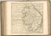

Comitatus Northantonensis; Vernacule Northamton Shire. [Karte], in: Theatrum orbis terrarum, sive, Atlas novus, Bd. 4, S. 320.
1 Karte aus Atlas Blaeu, Joan Blaeu, Willem Janszoon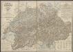
Comitatus Northantonensis; Vernacule Northampton Shire. [Karte], in: Le théâtre du monde, ou, Nouvel atlas contenant les chartes et descriptions de tous les païs de la terre, Bd. 4, S. 280.
1 Karte aus Atlas Blaeu, Willem Janszoon und Blaeu, Joan Blaeu, Willem Janszoon
Comitatus Northantonensis vernacule Northamton Shire
1 : 220000 [Amstelodami] : [apud Joannem Janssonium]
COMITATVS | NORTHANTO- | NENSIS; | Vernacule | NORTHAMTON SHIRE.
[Amsterdam : Joan Blaeu]
Leicestrensis comitatvs
1 Karte : Kupferdruck ; 37 x 48 cm Blaeu Joan Blaeu
Leicestrensis Comitatus cum Rutlandiae vulgo Leicester & Rutland Shire
1 : 160000 Amstelodami : ex. Joannes Janssonius