Maps of Plymouth

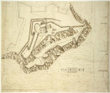
A plan of "Plimouth Forte," now the citadel; drawn by Federico Genibelli, (the same as Cotton Ms. Augustus I. i. 40) on a scale of 40 paces to 3 inches, about 1602; with profiles of the works
This is a detailed drawing of Plymouth Fort by the Italian military engineer Federico Genibelli. It dates from 1602. Genibelli came to England in 1585 after engineering a sensational, though ultimately unsuccessful, stroke against Parma during the siege of Antwerp where his attempt to destroy a pontoon bridge with explosive ships was noted. He was taken into the Queen’s service in connection with mobilization against the Armada. Although the Spanish were dramatically defeated by the English in 1588, England remained at war with Spain for many years and further attempts to invade were made by Philip of Spain with the dispersal of the ‘second Armada’ in October 1596 and the assembly of the ‘third Armada’ in the following spring. It was therefore important in this climate of continued tension, that defences be in serviceable condition. This drawing was produced after the Privy Council gave instruction that the fort be surveyed following the complaints made by the Captain of the Fort, John Gilbert, that the building works were defective and inadequate. The drawing shows that the fort consisted of two parts, an upper enclosure on the higher ground and a lower one extending down to the shore of Plymouth Sound. The upper and principal fort was roughly triangular in shape but the lower one was extremely irregular, fitting closely to the shape of the rocks on which it stood. Two large bulwarks faced north, inland, to defend the fort against a land-based enemy attack. The main armament of guns was placed in the lower enclosure facing the Sound in order to defend the fort from enemy ships. There was a ditch 20 feet wide along the landward sides. Within the walls were the captain’s house, the soldier’s barracks and the chapel, all are clearly shown here. The defence of the Sound, which gave sea access to the mainland, was the forts primary purpose. Genibelli, Frederico
Insurance Plan of Plymouth: sheet 7-1
1 : 480 This detailed 1891 plan of Plymouth is one of a series of eight sheets in an atlas originally produced to aid insurance companies in assessing fire risks. The building footprints, their use (commercial, residential, educational, etc.), the number of floors and the height of the building, as well as construction materials (and thus risk of burning) and special fire hazards (chemicals, kilns, ovens) were documented in order to estimate premiums. Names of individual businesses, property lines, and addresses were also often recorded. Together these maps provide a rich historical shapshot of the commercial activity and urban landscape of towns and cities at the time. The British Library holds a comprehensive collection of fire insurance plans produced by the London-based firm Charles E. Goad Ltd. dating back to 1885. These plans were made for most important towns and cities of the British Isles at the scales of 1:480 (1 inch to 40 feet), as well as many foreign towns at 1:600 (1 inch to 50 feet). Chas E Goad Limited Chas E Goad Limited
Insurance Plan of Plymouth: sheet 6-1
1 : 480 This detailed 1891 plan of Plymouth is one of a series of eight sheets in an atlas originally produced to aid insurance companies in assessing fire risks. The building footprints, their use (commercial, residential, educational, etc.), the number of floors and the height of the building, as well as construction materials (and thus risk of burning) and special fire hazards (chemicals, kilns, ovens) were documented in order to estimate premiums. Names of individual businesses, property lines, and addresses were also often recorded. Together these maps provide a rich historical shapshot of the commercial activity and urban landscape of towns and cities at the time. The British Library holds a comprehensive collection of fire insurance plans produced by the London-based firm Charles E. Goad Ltd. dating back to 1885. These plans were made for most important towns and cities of the British Isles at the scales of 1:480 (1 inch to 40 feet), as well as many foreign towns at 1:600 (1 inch to 50 feet). Chas E Goad Limited Chas E Goad Limited
Insurance Plan of Plymouth: sheet 6-2
1 : 480 This detailed 1891 plan of Plymouth is one of a series of eight sheets in an atlas originally produced to aid insurance companies in assessing fire risks. The building footprints, their use (commercial, residential, educational, etc.), the number of floors and the height of the building, as well as construction materials (and thus risk of burning) and special fire hazards (chemicals, kilns, ovens) were documented in order to estimate premiums. Names of individual businesses, property lines, and addresses were also often recorded. Together these maps provide a rich historical shapshot of the commercial activity and urban landscape of towns and cities at the time. The British Library holds a comprehensive collection of fire insurance plans produced by the London-based firm Charles E. Goad Ltd. dating back to 1885. These plans were made for most important towns and cities of the British Isles at the scales of 1:480 (1 inch to 40 feet), as well as many foreign towns at 1:600 (1 inch to 50 feet). Chas E Goad Limited Chas E Goad Limited
An Exact Plan of the Royal Citadel and Town of Plymouth
A plan of the town, citadel, dock, and country round Plymouth. Located in the south western peninsula of England, Plymouth Harbour commands the western approaches to the island and by the 16th century had become the country’s most important naval seaport. The citadel was built on the Hoe- the name means high ground’ and it was the highest point in the area, in 1670. It was built in 1662 for Charles II as a fortress against the local Parliamentarians. In 1690 the first Royal Dockyard opened on the banks of the Tamar to the west of Plymouth. Further docks were built in 1727, 1762 and 1793, and a huge naval complex was later established here.
Devon CXXIII.12 (includes: East Stonehouse; Plymouth; Plymstock) - 25 Inch Map
1 : 2500 Topographic maps Ordnance Survey Ordnance Survey
Devon CXXIII.12 (includes: East Stonehouse; Plymouth; Plymstock) - 25 Inch Map
1 : 2500 Topographic maps Ordnance Survey Ordnance Survey
Devon CXXIII.12 (includes: East Stonehouse; Plymouth; Plymstock) - 25 Inch Map
1 : 2500 Topographic maps Ordnance Survey Ordnance Survey
Devon CXXIII.12 (includes: East Stonehouse; Plymouth; Plymstock) - 25 Inch Map
1 : 2500 Topographic maps Ordnance Survey Ordnance Survey
Devon CXXIII.7 (inset CXXIII.8 & CXXIII.12) (includes: East Stonehouse; Plymouth; Plymstock) - 25 Inch Map
1 : 2500 Topographic maps Ordnance Survey Ordnance Survey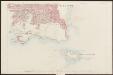
Devon CXXIII.12 (includes: East Stonehouse; Plymouth; Plymstock) - 25 Inch Map
1 : 2500 Topographic maps Ordnance Survey Ordnance Survey
Insurance Plan of Plymouth Vol. 1: Key Plans 2
1 : 4800 This "key plan" indicates coverage of the Goad 1891 series of fire insurance maps of Plymouth that were originally produced to aid insurance companies in assessing fire risks. The building footprints, their use (commercial, residential, educational, etc.), the number of floors and the height of the building, as well as construction materials (and thus risk of burning) and special fire hazards (chemicals, kilns, ovens) were documented in order to estimate premiums. Names of individual businesses, property lines, and addresses were also often recorded. Together these maps provide a rich historical shapshot of the commercial activity and urban landscape of towns and cities at the time. The British Library holds a comprehensive collection of fire insurance plans produced by the London-based firm Charles E. Goad Ltd. dating back to 1885. These plans were made for most important towns and cities of the British Isles at the scales of 1:480 (1 inch to 40 feet), as well as many foreign towns at 1:600 (1 inch to 50 feet). Chas E Goad Limited Chas E Goad Limited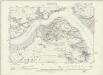
Devonshire CXXIII.SE - OS Six-Inch Map
1 : 10560 Topographic maps Ordnance Survey Ordnance Survey
A chart of Plymouth Sound, with "il novo recinto della fortificatione de la ville de Pleymouth;"
This is a plan of the area around Plymouth Sound. It is orientated to the south with Penlee point to the south west and Bovisand Bay south east. It dates from 1601-1602 and may show the proposals of the Italian engineer Frederico Genibelli. Genibelli had been sent by the Privy Council in response to requests by the governor of the fort, Sir John Gilbert, that defects in the fortifications be repaired. Plymouth Sound is situated in such a way as to make it an ideal invasion target as although geographically far from heart of national government Plymouth was accessible to the outside world, especially France and Spain and provided access to centre of the country. This plan illustrates the position occupied by the fort in relation both to the town and to its surrounding countryside, although the latter is inaccurately portrayed out of scale. The town of Plymouth is surrounded by a perimeter wall. Beacons are shown at Staddon, Maker and Penlee, highlighting the measures in place to raise the alarm in case of invasion. When surveying the deficiencies in the defences of the fort and island, Genibelli outlined a new scheme for fortifying the town with nine ravelins at a cost of £3000. These are outworks which consist of two faces which form a salient angle. The proposed scheme is clearly shown here but was not carried out by the government. Genibelli, Frederico
Devonshire CXXIII - OS Six-Inch Map
1 : 10560 Topographic maps Ordnance Survey Ordnance Survey
General Plan of the Ports of Homouse and Plymouth
Plan of the Ports of Hamoaze and Plymouth in Devon. This is the point where the rivers Tamar, Tavy and Lynher enter Plymouth Sound. Proposals for a dockyard at Hamoaze were first proposed by Sir Francis Drake in the late 16th century. It was felt that the broad estuary here afforded excellent natural protection however it was not until 1690 that work began here. William III appointed Edmund Dummer, surveyor to the Royal Navy, to build the dock and it became known as Plymouth Dock. By the 19th century Plymouth Dock was actually bigger than Plymouth itself and in 1824 it became independent, the town and the dockyard becoming known as Davenport. This is now the largest naval base in Western Europe.
Nieuwe afteekeningh van de haven van Plijmouth geleegen int Canaal aen de kust van Engeland
England Gerard van Keulen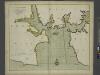
A new and correct large draught PLYMOUTH SOUND catt-water and ham-owse
from The sea-atlas : containing an hydrographical description of most of the sea-coasts of the known parts of the world.
To the Right Honorable the Master, Wardens & Elder Brethren of the Trinity House, this Chart of Plymouth Sound is ... dedicated
1 : 26000 Heather, W. (William) Heather, W. (William)
A coloured scheme for fortifying the island of St Nicholas, or Drake's Island, in Plymouth Sound
Plan of Plymouth harbour with particular attention to St Nicholas Island thought to have been drawn by a French or Dutch artist. It is said that when he was a child, Sir Francis Drake was sent here by his parents for protection at a time of civil disturbance. In the 18th century the island was renamed Drake’s Island in his memory but until the mid 19th century it was still referred to as St Nicholas Island. The island was first fortified in the 17th century and was important because it was situated in the centre of Plymouth Sound and protected the approaches to the harbours and the estuaries of the rivers Tamar and Plym.
The environs of Plymouth, Devonport and Stonehouse : also the neighborhood of Exeter with the coast and other principal roads [...]
1 : 65000 engraved [...] by John Cooke Stonehouse : sold by John Cooke
Plan of Plymouth harbour
Located in the south western peninsula of England, Plymouth Harbour commands the western approaches to the island and by the 16th century had become the country’s most important naval seaport. This plan depicts the harbour of Plymouth, as it was in the late 17th century, from St. Germains on the west to Saltram on the east.
A coloured chart of Plymouth Harbour, and of the country up to Tavistock; drawn possibly by Robert Spry
This is a map of Plymouth and environs and is a 16th century copy of an original map dating from 1591 by Robert Spry. Spry is recorded as a painter in municipal records between 1569-70 and 1591-2. The map is drawn in a somewhat archaic pictorial style with topographical details drawn in perspective. Great detail has been observed in the depiction of churches and country houses and three beacons, the means of alerting the surrounding area, are recorded. The anchorages of the Sound are marked by drawings of ships. The map shows the conduit or leat that was constructed by Sir Francis Drake in 1590-1 in order to provide a water-supply for the town from Dartmoor. In connection with his leat, Drake had been granted a lease of the six town mills in 1583. The leat was designed for the watering of ships and to power the mills and played a central role in Drake’s hopeful project to make Plymouth a powerful naval station. Although popular local tradition suggested that Drake had employed magic in order to effect the construction of the leat which passed through "mighti rockes which was thought unpossible to carrie water through", it was in fact the work of the Plymouth engineers Robert Lampen and his brother. Figures along the course of the leat, from the River Meavy to Plymouth record miles. A section that is likely to have contained an explanatory table has been removed, resulting in the maps irregular shape. Spry, Robert
Plymouth (Hills) - OS One-Inch Revised New Series
1 : 63360 Topographic maps Ordnance Survey Ordnance Survey
Plymouth (Outline) - OS One-Inch Revised New Series
1 : 63360 Topographic maps Ordnance Survey Ordnance Survey
Plymouth - OS One-Inch Map
1 : 63360 Topographic maps Ordnance Survey Ordnance Survey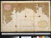
Een gedeelte van het Kanaal vant eijland Bun tot de R. van Vaalmouth
England Gerard van Keulen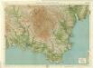
South Devon, Sheet 36 - Bartholomew's "Half Inch to the Mile Maps" of England & Wales
1 : 126720 Topographic maps Bartholomew, John George John Bartholomew & Co
Sheets 3-4. (Cary's England, Wales, and Scotland).
1 : 360000 Cary, John, ca. 1754-1835