Maps of Açores

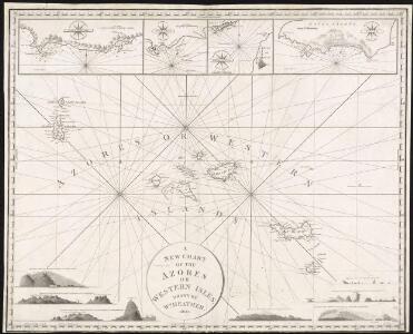
A new chart of the Azores or Western Isles
1 : 1020000 Heather, W. (William) Heather, W. (William)
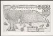
INSULÆ | AÇORES
delineante | LUDOVICO TEISERA | Reg. Maj. Cosmographo. Amstelædami, | Excud. Joannes Blaeu.
Chart of the Acores (Hawks) Islands.
1 : 1550000 Jefferys, Thomas
Açores Insulae. [Karte], in: Theatrum orbis terrarum, S. 92.
1 Karte aus Atlas Ortelius, Abraham Vrients, Jan Baptista
Portuguese Islands in the Atlantic Ocean.
Fullarton, A. & Co.
Atlantic Islands.
Society for the Diffusion of Useful Knowledge (Great Britain)
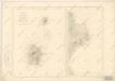
Carte bathymétrique des Iles Açores
1 : 660000 Thoulet, Marie Julien Olivier Imprimerie Vieillemard Fils et Cie.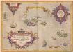
Açores Insulae. [Karte], in: Theatrum orbis terrarum, S. 45.
1 Karte aus Atlas Ortelius, Abraham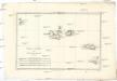
Isles Açores
1 : 1730000 Azory Bonne, Rigobert André
Insulae Flandricae, olim Asores Dictae. [Karte], in: Novus atlas absolutissimus, Bd. 9, S. 244.
1 Karte aus Atlas Janssonius Offizin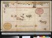
Afteekening van de Vlaamse Eijlanden met alle hunnen dieptens int groodt
Portugal Gerard van Keulen
Azore Ids.
1 : 2300000 Lucas, Fielding Jr.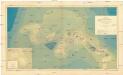
Carte bathymétrique des Iles Açores
Azory (Portugalsko : souostroví) Thoulet, M. J. Tollemer, A. Vieillemard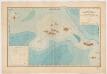
Carte bathymétrique des Iles Açores : d'après les cartes française et anglaises, les sondages du "Talisman", du "Challenger" de S.A.S. le Prince de Monaco
1 : 650000 Thoulet, J. (Marie Julien Olivier), 1843-1936 Viellemard Fils et Cie.
Carte des Iles Acores d ́aprés les travaux exécutés en 1843 et 1844
Carte des Iles Acores d ́aprés les travaux exécutés en 1843 et 1844
A cidade de Angra na ilha de Iesu xpo da Tercera que esta em 39. graos.
1 : 1
Carta corográfica da Ilha Terceira
1 : 50000 Instituto Geográfico e Cadastral
Carte des Iles Acores d ́aprés les travaux exécutés en 1843 et 1844

Iles Acores. Afrique 1 bis.
1 : 1641836 Vandermaelen, Philippe, 1795-1869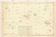
Itinéraires du yacht "Princesse Alice" dans l'archipel des Açores, 1895,1896,1897
Azory (Portugalsko : souostroví) Tollemer, A. Imprimerie Vieillemard
A chart of the Canary islands, including Madeira
Kanárské ostrovy Borda, Jean-Charles de Norie & Co.
A New Chart of the Madeira and Canary Islands
1 : 1200000 Heather, W. (William) Heather, W. (William)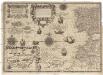
Cassiterides insulae vulgo Asores, & naucleris belgicis insulae Flandricae dictae, quod Brugenses Flandri, ipsas primi detexerint & habitaverint, cum antea incultissimae essent
1 : 548000 Azory Doetechum, Johannes Baptista van
Carte pour resoudre les six problemes 1749
1 : 15000000 Mollova mapová sbírka
Carte pour resoudre les six problemes
1 Karte : Kupferdruck ; 17 x 13 cm, Bildgrösse 22 x 34 cm Königliche Akademie der Wissenschaften
Nieuwe pas-caart; vertoonende, hoemen uyt de canaal, de custen van Portugael, Barbarijen, de Canarische en Vlaemsche eylanden beseylen zal
1 Karte : Kupferdruck ; 42 x 54 cm Doncker by Hendrick Doncker boekverkoper inde Nieubrugsteech in 't Stuurmans gereetschap
A chart of the coast of Barbaria with the western, Canaria, & Cape de Verd, isles
1 : 6000000
Pascaart, Waer in men claarlyck zien can, alle havens rivieren droogten, gelegen tußchen C.S. Vincent en C. Verde [...] [Karte], in: Novus atlas absolutissimus, Bd. 9, S. 239.
1 Karte aus Atlas Janssonius Offizin