Maps of Seven Seas (Open Ocean)

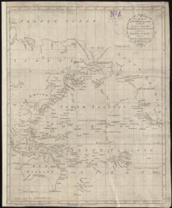
A chart of the discoveries made by the late Capt. Cook, & other European navigators, in the great Pacific Ocean between Asia and America
Kitchin, Thomas Baldwin, Richard
Composite: Pacific Ocean.
1 : 25000000 John Bartholomew and Son
Atlas über die Entwicklung von Industrie und Handel der Schweiz in dem Zeitraume vom Jahr 1770 bis zum Jahr 1870
1 : 45000000 1 Atlas ([3], VIII Bl.) im Auftrage der schweizerischen Commission für die additionellen Ausstellungen in Wien, bearbeitet von Dr. Hermann Wartmann Wurster Randegger & Co., Winterthur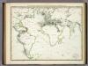
Die Vulkanischen Erscheinungen Der Atlen Welt.
1 : 65000000 Berghaus, Heinrich
Longueurs du pendule.
1 : 75000000 L'Isle, Guillaume de, 1675-1726

Animals - World.
Woodbridge, William C.
Isothermal chart, productions.
1 : 80000000 Woodbridge, William C.
Isothermal chart.
1 : 95000000 Woodbridge, William C.
Inhabited World.
1 : 93000000 Woodbridge, William C.
Le monde ou panorama géographique du globe terrestre, représentant les terres et les mers du globe, ses accidents physiques, les phénomènes, les règnes de la nature [...]
1 : 177600000 réd. d'après Mr. De Humbold et les savans les plus distingués par E. Hocquart [S.l.] : [s.n.]
Ocean Atlantique et Ocean Indien.
1 : 50000000 Vivien St Martin, L.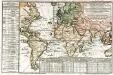
Carte des lieux où les differentes longueurs du pendule à secondes ont été observées
1 Karte : Kupferdruck ; 24 x 37 cm, Blattgrösse 46 x 61 cm Buache Philippe Buache
Atlantic Ocean.
1 : 95000000 Huntington, Hezekiah, 1795-1865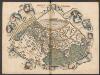
Generale Ptholemei [Karte], in: Claudii Ptolemei viri Alexandrini mathematice discipline philosophi doctissimi geographie opus [...], S. 148.
1 Karte aus Atlas Waldseemüller, Martin [und Ptolemaeus, Claudius] Übelin, Georg
Map Of Oceanica.
1 : 100000000 Mitchell, Samuel Augustus
Afrique : d'après les documents les plus récents et les derniers traitès
1 : 18000000 Giffault, E Le Temps Bureaux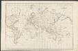
Allgemeine Weltcharte
1 : 45400000 nach Mercators Projection entworfen von A.I. Krusenstern, Capitain der Russischen Marine J. Walker sculpt. ; verb. bis zum Jahre 1818. London : [s.n.]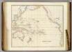
Pacific Ocean.
1 : 40000000 Arrowsmith, John
Oceanica, Sandwich Islands.
1 : 70000000 Mitchell, Samuel Augustus
Oceanica, Sandwich Islands.
1 : 70000000 Mitchell, Samuel Augustus
Oceanica, Sandwich Islands.
1 : 70000000 Mitchell, Samuel Augustus Jr.
Oceanica, Sandwich Islands.
1 : 70000000 Mitchell, Samuel Augustus
Oceanica, Sandwich Islands.
1 : 70000000 Mitchell, Samuel Augustus
Orbis Terrarum Veteribus Cogniti Typus Geographicus. [Karte], in: Novus atlas absolutissimus, Bd. 10, S. 8.
1 Karte aus Atlas Janssonius Offizin
Mappe-Monde = Geo-Hydrographique, ou Descritption Generale Du Globe Terrestre Et Aquatique En Deux-Plans-Hemispheres. [Karte], in: Atlas nouveau, contenant toutes les parties du monde [...], Bd. 1, S. 32.
1 Karte aus Atlas Sanson, Nicolas Jaillot, Alexis Hubert und Mortier, Pieter
Pacific Ocean : compiled from Admiralty surveys & other official sources
1 : 15000000 India-Rubber, Gutta-Percha & Telegraph Works Co J.D. Potter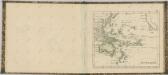

America
A new general atlas of modern geography, consisting of a complete collection of maps of the four quarters of the globe Wyld, James James Wyld