Maps of Carlow

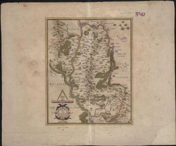
Vdrone Irlandiæ in Catherlagh Baronia
1 : 66530

BARONIA | UDRONE | IN COMITATU | CATHERSOUGHÆ
[Amsterdam : Joan Blaeu]
Udrone, Irlandiae in Catherlagh Baronia. [Karte], in: Atlas, sive, Cosmographicae meditationes de fabrica mundi et fabricati figura, S. 104.
1 Karte aus Atlas Mercator, Gerhard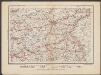
Udrone Irlandiae in Catherlagh Baronia. [Karte], in: Gerardi Mercatoris Atlas, sive, Cosmographicae meditationes de fabrica mundi et fabricati figura, S. 88.
1 Karte aus Atlas Mercator, Gerhard Montanus, Petrus
Baronia Udrone in comitatu Catherlovghæ
1 Karte : Kupferdruck ; 38 x 25 cm Blaeu Joan Blaeu
Vdrone, Irlandiæ in Catherlagh baronia
1 Karte : Kupferdruck ; 33 x 26 cm Mercator; Hondius Henricus Hondius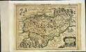
Udrone Irlandiae in Catherlagh baronia
1 Karte : Kupferdruck ; 17 x 24 cm Mercator; Keere Cloppenburgh
Vdrone, Irlandiæ in Catherlagh baronia
1 Karte : Kupferdruck ; 33 x 27 cm Mercator; Hondius Jodocus Hondius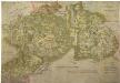
A Coloured Map of Offalia, now forming King's and Queen's Counties
This is a map the counties of Leix and Offaly in Ireland and records the area around the time of the time of the English plantation scheme. This scheme involved the division of the counties of Donegal, Londonderry, Tyrone, Fermanagh, Armagh and Cavan into plots of land to be given to English and Scottish settlers and Irish who agreed to plant and conform to Protestantism. The cartographer of this map is unknown but it is thought to have been produced in around 1565. Leix and Offaly had been shired by the Earl of Sussex in 1557 and this map was made in connection with the plantations. Settlements are indicated by generalized symbols of buildings. The relief of the land is indicated by hills drawn in perspective and coloured brown, woodland is shown by a representation of tree tops in green, other land is coloured yellow. This map is interesting in that it includes the names of English settlers and indicates by dotted lines the pathways through the woodland and bogs.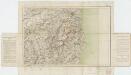
Sheet 11, uit: Ireland
1 : 253440 Annotatie: Voor aanwezige bladen zie overzichtsblad; Alle bladen met aantekeningen in kleurpotlood of inkt; Annotatie geografische gegevens: Maps on the scale of four miles to one inch; Op elk blad een diagram van aangrenzende bladen en een indexdiagram van de corresponderende bladen van de 'one inch map' Dublin : Ordnance Survey of Ireland
Lagenia; anglis Leinster
1 Karte : Kupferdruck ; 38 x 48 cm Blaeu Joan Blaeu
Comitatus Lageniae The Countie of Leinster. [Karte], in: Novus atlas absolutissimus, Bd. 8, S. 195.
1 Karte aus Atlas Janssonius Offizin
Comitatus Lageniae The Countie of Leinster. [Karte], in: Gerardi Mercatoris et I. Hondii Newer Atlas, oder, Grosses Weltbuch, Bd. 1, S. 57.
1 Karte aus Atlas Mercator, Gerhard und Hondius, Jodocus Jansson, Jan
Ireland SE.
1 : 486830 Stanford, Edward
Momonia, hibernice Moun et Woun; anglice Mounster
1 Karte : Kupferdruck ; 40 x 50 cm Blaeu Joan Blaeu
Ireland 4.
1 : 760320 Letts, Son & Co.
Provincia Connachtiae = The province of Connaugt
1 : 790000 Amstelodami : ex officina Petri Schenk et Gerardi Valk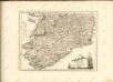

LAGENIA; | Anglis | LEINSTER.
[Amsterdam : Joan Blaeu]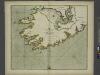
The SOUTH-WEST coast of IRELAND from Dungarvan to the River Shannon
from The sea-atlas : containing an hydrographical description of most of the sea-coasts of the known parts of the world.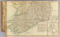
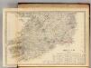
Ireland (south)
1 : 380000 Robert Laurie & James Whittle
Provincia Connachtiae The Province of Connaugt [Karte], in: Gerardi Mercatoris et I. Hondii Newer Atlas, oder, Grosses Weltbuch, Bd. 1, S. 60.
1 Karte aus Atlas Mercator, Gerhard und Hondius, Jodocus Jansson, Jan
Provincia Connachtiae = The province of Connaugt
1 : 790000 Amstelodami : excudebat Joannes Janssonius
Comitatus Lageniae = The countie of Leinster
1 : 1200000 Amstelodami : apud Joannem Janssonium
MOMONIA, | Hibernice | MOUN et WOUN; | Anglice | MOUNSTER
[Amsterdam : Joan Blaeu]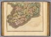
Ireland southern.
1 : 700000 Lizars, Daniel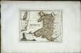
Das Fürstenthum Wales
1 Karte : Kupferdruck ; 19 x 26 cm Reilly F. J. J. von Reilly
Connachtia vulgo Connaughty
1 Karte : Kupferdruck ; 38 x 48 cm Blaeu Joan Blaeu