Maps of South West England

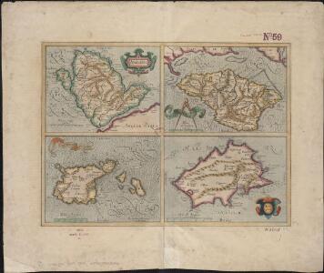
Anglesey; Wight Vectis olim ; Garnesay ; Iarsay
1 : 1
Galliæ antiquæ descriptio geographica, 1
1 Blatt : 44 x 57 cm s.n.
Carte de l'Angleterre au tems des conquétes des Romains
1 Karte : Kupferdruck ; 23 x 22 cm s.n.
Parte meridionale dell' Inghilterra, e del principato di Galles
1 Karte : Kupferdruck ; 29 x 40 cm Zatta; Zuliani; Pitteri presso Antonio Zatta
England, Wales.
1 : 1050000 Rand McNally and Company
Composite: England and Wales.
1 : 887000 Johnston, Alexander Keith
England and Wales (Southern section)
1 : 675000 Rocque, John
Ten mile map of Great Britain
1 : 633600 Velká Británie Ordnance Survey Office
Partie meridionale de l'Angleterre
1 Karte : Kupferdruck ; 53 x 84 cm s.n.
Carte de l'Angleterre au tems de la decente des romains
1 Karte : Kupferdruck ; 24 x 22 cm s.n.
England and Wales.
1 : 1420000 Hammond, C.S.
England, south.
1 : 980000 Lizars, Daniel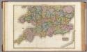
England, southern part.
1 : 755000 Pinkerton, John, 1758-1826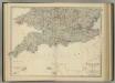
England and Wales (southern sheet).
1 : 887000 Johnston, Alexander Keith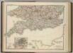
England and Wales (southern sheet).
1 : 887000 Johnston, W. & A.K.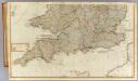
(England, Wales, south)
1 : 575000 Kitchin, Thomas; Phillips, J.; Robert Laurie & James Whittle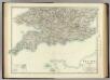
England and Wales (southern sheet).
1 : 887000 Johnston, Alexander Keith
Road map of Great Britain
1 : 633600 Birmingham (Anglie) Ordnance Survey Office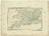
Postkarte von Süd England
Anglie jižní Ponheimer, Kilian im von Reillyschen Landkarten und Kunstwerke Verschleiss Komptoir
Carte du Canal ou de la Manche, 2
1 Blatt : 74 x 52 cm Esnauts et Rapilly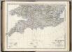
England, Wales S.
1 : 887000 Johnston, Alexander Keith, 1804-1871
Grossbritannien Südlicher Theil
Adolf Stieler's Handatlas über alle Theile der Erde und über das Weltgebäude Stieler, Adolf Justus Perthes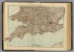
England, Wales S.
1 : 1000000 Andree, Richard; Times (London, England)
A new and accurate map of all the direct & principal cross roads in England and Wales
Anglie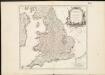
Le Royaume d'Angleterre , divisé selon les sept Royaumes, ou Heptarchie des Saxons, avec la Principauté de Galles, et subdivisé en shires ou comtés
1 : 1400000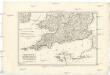
Royaume d'Angleterre
1 : 1950000 Anglie jižní Bonne, Rigobert
Grossbritannien. Sudliches Blatt: England U. Wales.
1 : 1500000 Petermann, A.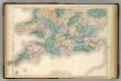
England and Wales.
1 : 900000 Hughes, William
Grossbritannien im maassstabe von 1:1.500.000 : sudliches Blatt : England (ohne die nordl. Grafschaften) u. Wales
1 : 1500000 Petermann, August Heinrich 1822-1878 Gotha : Justus Perthes