Maps of Lot

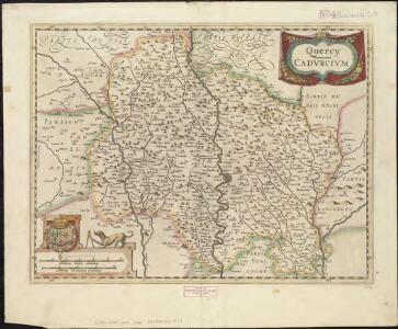
Quercy : Cadurcium
1 : 365000
Quercy, olim Cadurcium
1 : 370000 Schenk, Pieter apud Gerardum Valk et Petrum Schenk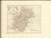

Cadurcium Vernaculé Querci. [Karte], in: Theatrum orbis terrarum, sive, Atlas novus, Bd. 2, S. 134.
1 Karte aus Atlas Blaeu, Joan Blaeu, Willem Janszoon

Quercy Cadurcium [Karte], in: Novus atlas absolutissimus, Bd. 4, S. 179.
1 Karte aus Atlas Janssonius Offizin
Cadurcium Vernaculé Querci. [Karte], in: Le théâtre du monde, ou, Nouvel atlas contenant les chartes et descriptions de tous les païs de la terre, Bd. 2, S. 146.
1 Karte aus Atlas Blaeu, Willem Janszoon und Blaeu, Joan Blaeu, Willem Janszoon
Quercy. Cadurcium
Quercy. Cadurcium. [By J. Jansen] [Amsterdam?]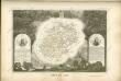
Dept. Du Lot.
1 : 555000 Levasseur, Victor.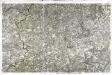
[Cahors]
1 Blatt : 56 x 89 cm s.n.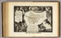
Dept. De Tarn et Garonne.
1 : 571000 Levasseur, Victor.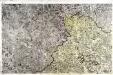
[Sarlat]
1 Blatt : 56 x 89 cm s.n.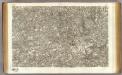
36 Cahors.
1 : 86400 Cassini family; Cassini, Cesar-Francois, 1714-1784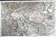
[Montauban]
1 Blatt : 56 x 89 cm Aldring; Bourgoin s.n.
Govverneme[n]t de Montauban
1 Karte : Kupferdruck ; 11 x 15 cm Sebastian Cramoisy
35 Sarlat.
1 : 86400 Cassini family; Cassini, Cesar-Francois, 1714-1784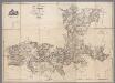
Carte topographique du Canton de St. Antonin, Arrond.t de Montauban, Département de Tarn-et-Garonne / par Aubry
1 : 30000 Aubry, ... [S.l. : s.n.]
Govvernement de Caussade
1 Karte : Kupferdruck ; 11 x 15 cm Sebastian Cramoisy
A colored plan of Montauban; drawn about 1700
A colored manuscript plan of Montauban, Tarn-et-Garonne; drawn about 1700, on a scale of 90 toises to an inch.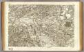
37 Montauban.
1 : 86400 Cassini family; Cassini, Cesar-Francois, 1714-1784
Quercy, olim Cadurcium. [Karte], in: Novus atlas absolutissimus, Bd. 4, S. 182.
1 Karte aus Atlas Janssonius Offizin
33) XI.N.O. ''Perigueux'', uit: Carte géologique de France
1 : 500000 Annotatie: Voor aanwezige bladen zie bladoverzicht [S.l : s.n.]
Coste de Gascogne
Gaskoňsko (Francie) Duval, Pierre Picard, Jacques N. Langois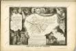


Dioecesis Sarlatensis, Vernacule Le Dioecese De Sarlat. [Karte], in: Novus Atlas, das ist, Weltbeschreibung, Bd. 2, S. 136.
1 Karte aus Atlas Blaeu, Joan Blaeu, Willem Janszoon