Maps of Mortagne-au-Perche
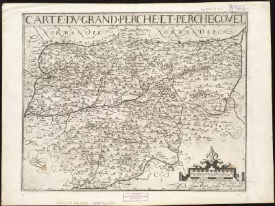
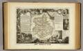
Carte du Grand Perche et Perche Gouet
1 : 285000
Perchensis Comitatus La Perche Comté [Karte], in: Le théâtre du monde, ou, Nouvel atlas contenant les chartes et descriptions de tous les païs de la terre, Bd. 2, S. 104.
1 Karte aus Atlas Blaeu, Willem Janszoon und Blaeu, Joan Blaeu, Willem Janszoon
Perchensis Comitatus La Perche Comté [Karte], in: Theatrum orbis terrarum, sive, Atlas novus, Bd. 2, S. 70.
1 Karte aus Atlas Blaeu, Joan Blaeu, Willem Janszoon
Perchensis Comitatus La Perche Comte [Karte], in: Novus atlas absolutissimus, Bd. 4, S. 118.
1 Karte aus Atlas Janssonius Offizin
Perchensis Comitatus La Perche Comté [Karte], in: Novus Atlas, das ist, Weltbeschreibung, Bd. 2, S. 106.
1 Karte aus Atlas Blaeu, Joan Blaeu, Willem Janszoon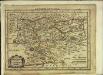
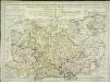
Perchensis comitatus
1 Karte : Kupferdruck ; 17 x 25 cm Mercator Cloppenburgh
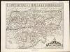
Perchensis comitatvs
2 Karten auf 1 Blatt : Kupferdruck ; Bildgrösse 39 x 50 cm Janssonius; Du Temps Joannes Janssonius
Perchensis comitatvs
2 Karten auf 1 Blatt : Kupferdruck ; Bildgrösse 39 x 50 cm Blaeu; Du Temps apud Guiljelmum Blaeuw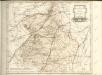
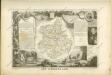
Dept. De L'Eure et Loir.
1 : 568000 Levasseur, Victor.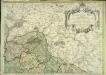
Partie superieure orientale de l'evesché du Mans
1 Blatt : Jaillot
[Chartres]
1 Blatt : 60 x 91 cm Brunet; Desbruslins s.n.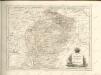
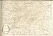
[Evreux - Dreux]
1 Blatt : 60 x 91 cm s.n.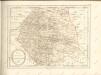

Plan zur Schlacht vor Le Mans, am 10-ten, 11-ten und 12-ten Januar
1 : 40000 Le Mans (Francie) Greve, Wilhelm Kgl. Hofbuchh. v. E. S. Mittler & Sohn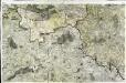
[Alençon]
1 Blatt : 60 x 91 cm s.n.
Carte de Beauce
1 Karte : Kupferdruck ; 11 x 16 cm Sebastian Cramoisy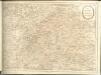

Chartres
1 Plan : Kupferdruck ; 11 x 15 cm Sebastian Cramoisy
L'Evesché de Chartres dìvìsee en archìdìaconéz et doyennéz
1 : 211000
15) V.S.O. ''Le Mans'', uit: Carte géologique de France
1 : 500000 Annotatie: Voor aanwezige bladen zie bladoverzicht [S.l : s.n.]
Gouvernement du Maine et du Perche
1 Karte : Kupferdruck ; 32 x 42 cm Chanlaire; Mentelle; Blondeau chez les auteurs P. G. Chanlaire rue Geoffroy-Langevin n.o 328, et E. Mentelle cour du Louvre n.o 7
Le Maine [Karte], in: Gerardi Mercatoris et I. Hondii Newer Atlas, oder, Grosses Weltbuch, Bd. 2, S. 71.
1 Karte aus Atlas Mercator, Gerhard und Hondius, Jodocus Jansson, Jan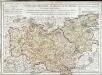
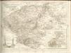
Carte des provinces du Maine et du Perche
1 Karte : Kupferdruck ; 45 x 63 cm L'Isle chez l'auteur sur le quai de l'Horloge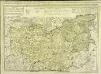
Carte des provinces du Maine et du Perche
1 Karte auf 2 Blättern : Kupferdruck ; 44 x 62 cm L'Isle chez Jean Cóvens et Corneille Mortier geographes