Maps of North Carolina
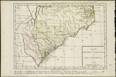
Carte des deux Carolines et de la Géorgie
1 : 2800000 Hilliard d'Auberteuil, Michel René
North Carolina, South Carolina, Georgia and eastern Tennessee
1 : 2000000 Charleston (Jižní Karolína) Bumstead, Albert H. National Geographic Society
Virginiae partis australis et Floridae partis orientalis, interjacentium[que] regionum nova descriptio
1 : 2400000 Jansson, Jan Jansson, Jan
Virginia, North Carolina, South Carolina, & Georgia, Operations of the Southern Armies.
1 : 2000000 Marshall, John
N. & S. Carolina.
1 : 1770000 Society for the Diffusion of Useful Knowledge (Great Britain)
North Carolina, South Carolina, Georgia and Eastern Tenessee

Virginiae item et Floridae Americae Provinciarum, nova descriptio.
The map portrays an area extending from Chesapeake Bay in Virginia to St. Augustine, Florida. Small illustrations of American Indians, local wildlife, ships and sea creatures appear on the map. There is a large rectangular cartouche in the upper left corner with an oval on each side that show differences in the buildings and fortifications between settlements in Florida and Virginia. Captions in lower left and throughout. Mercator, Gerhard, 1512-1594.; Hondius, Hendrik, 1597-1651.
North Carolina and South Carolina.
1 : 1550000 Johnson, A.J.
North Carolina and South Carolina.
1 : 1550000 Johnson, A.J.
North Carolina. South Carolina.
1 : 1431000 Hammond, C.S.
Map of North and South Carolina, and Georgia.
1 : 1800000 Mitchell, Samuel Augustus
Map Of North and South Carolina And Georgia.
1 : 1750000 Finley, Anthony
North Carolina, South Carolina, Georgia.
1 : 1788000 Finley, Anthony
North Carolina and South Carolina.
1 : 1267000 Colton, G.W.
North Carolina, South Carolina, Georgia and Eastern Tennessee
N. & S. Carolina.
1 : 1750000 Rand McNally and Company
North & South Carolina.
1 : 1100000 Tanner, Henry S.
North Carolina and South Carolina.
1 : 1280000 Asher & Adams
The State of South Carolina, from the bests authorities.
from Carey's general atlas, improved and enlarged : being a collection of maps of the world and quarters, their principal empires, kingdoms, &c.
North Carolina and South Carolina.
1 : 1550000 Johnson, A.J.
North And South Carolina.
1 : 1530000 Johnson, A.J.
Composite: North & South Carolina.
1 : 530000 Jefferys, Thomas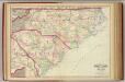
N. & S. Carolina.
1 : 1267200 Asher & Adams
N. & S. Carolina.
1 : 2400000 Mitchell, Samuel Augustus
N. & S. Carolina.
1 : 2400000 Mitchell, Samuel Augustus
N. & S. Carolina.
1 : 2400000 Mitchell, Samuel Augustus Jr.
N. & S. Carolina.
1 : 2400000 Mitchell, Samuel Augustus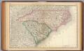
North and South Carolina.
1 : 2100000 Rand McNally and Company
North and South Carolina.
1 : 1330560 Cram Atlas Company
N. & S. Carolina.
1 : 2500000 Mitchell, Samuel Augustus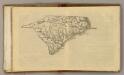
(N Carolina, S Carolina)
1 : 4200000 Moore, M. B. (Marinda Branson), 1829-1864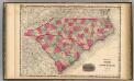
North And South Carolina.
1 : 1584000 Johnson, A.J.
North and South Carolina.
1 : 2500000 Greenleaf, Jeremiah
North and South Carolina.
1 : 2724480 Greenleaf, Jeremiah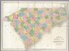
Map of North And South Carolina.
1 : 633600 Burr, David H., 1803-1875
North and South Carolina.
1 : 2661120 Burr, David H., 1803-1875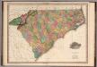
Map of North & South Carolina.
1 : 1100000 Tanner, Henry S.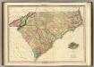
Map Of North & South Carolina.
1 : 1140480 Tanner, Henry S.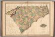
Map of North & South Carolina.
1 : 1100000 Tanner, Henry S.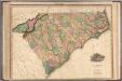
Map of North & South Carolina.
1 : 1100000 Tanner, Henry S.