Maps of Appalachian Mountains

An improved map of the United States
United States of America.
1 : 5900000 Cary, John, ca. 1754-1835
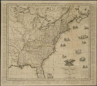
A new map of the United States of America, from the latest authorities / by John Cary, engraver.
from Whole John Cary,
Carte de l'Amérique septentrionale, depuis la baye d'Hudson jusqu'au Mississipi: pour servir aux essais historiques et politiques sur la révolution de cette partie du monde.; Essais historiques et politiques sur les Anglo-Américains, par M. Hilliard d'Auberteuil ...
from Essais historiques et politiques sur les Anglo-Américains, par M. Hilliard d'Auberteuil ... Hilliard d'Auberteuil, Michel René,
Vereinigte Staaten von Nord Amerika, ohne das West Gebiet der Union

The Seat of Civil War in America.
The Seat of Civil War in America. Published by Smith & Son of London in August 1863, The Seat of Civil War in America highlights the Union and Confederate states, as well as clearly marking the Border States in yellow. Interestingly this map still presents Virginia as one state. The smaller map shows the Seat of War in Virginia, detailing the areas of the state closest to Maryland and Washington, D.C., as well as southern Pennsylvania. Smith & Son
Map of the United States.
1 : 3660000 Carey, Mathew
Map of the United States.
1 : 3675000 Carey, Mathew
United States.
1 : 9200000 Greenleaf, Jeremiah
United States.
1 : 9250000 Greenleaf, Jeremiah
Karte der katholischen Diocesen und deren Missionen in Nordamerika nach den neuesten geographischen Angaben
1 : 22430000 Spojené státy americké-oblast východní Salzbacher, Joseph Engel, H. Joseph Salzbacher
U.S. Eastern.
1 : 8870400 Letts, Son & Co.
Mitchell's map of the United States : showing the principal travelling turnpike and common roads, on which are given the distances in miles from one place to another, also the courses of the canals & rail roads throughout the country, carefully compi
from Whole
Map of the United States.
1 : 2000000 Walker, John & Alexander
Map Of The United States Of North America.
1 : 2154240 Vance, David H.
New Map of the United States. (Proposal to publish.)
Vance, David H.
A new map of the English empire in America: viz. Virginia, Maryland, Carolina, New York, New Iarsey, New England, Pennsylvania, Newfoundland, New France &c. / revis'd by Ion. Senex, 1719; I. Harris, sculp.
from John H. Levine Collection John Senex; I. Harris,
A new map of the English empire in America: viz. Virginia, Maryland, Carolina, New York, New Iarsey, New England, Pennsylvania, Newfoundland, New France &c. / revis'd by Ion. Senex, 1719; I. Harris, sculp.
from Charts and maps John Senex; I. Harris,
Carte des Etats-Unis

Die Vereinigten Staaten von Nord-Amerika
Allgemeiner Atlas [Walch, Johannes] im Verlag bei Johannes Walch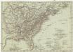
Vereinigte Staaten in Nord America
1 : 10000000 Spojené státy americké-oblast jihovýchodní T. Mollo
Composite: Colonie Unite dell' America Settentrle.
1 : 2100000 Zatta, Antonio
A Map of Carolana and of the River Meschacebe &c.
from Charts and maps Printed for B. Cowse?: [London],
Die Neuenglandstaaten bis 1783
1 : 16000000 Berlin : Mittler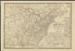
Nouvelle carte des États-Unis, du Haut et Bas-Canada, de la Nouvelle-Écosse, du Nouvau-Brunswick, de Terre-Neuve, etc.
1 : 4000000 dressée par A. H. Brué, géographe du Roi Paris : chez l'auteur
Etats-Unis, Canada, Floride.
1 : 13500000 Delamarche, Charles Francois; Lattre, Jean
Mitchell's travellers guide through the United States : a map of the roads, distances, steam boat & canal routes &c. / by J.H. Young ; engraved on steel by J.H. Young & D. Haines.
from Whole
Map Of The United States
1 : 2300000 Vance, David H.
Vereinigte Staaten in Nord America: nach den besten Hülfsmittel verfast / Wien bey T. Mollo.; Lorenz Rieder sc.
from Charts and maps Wien bey; T. Mollo. Lorenz Rieder,