Maps of Montréal
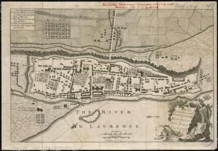
Plan of the town and fortifications of Montreal or Ville Marie in Canada
1 : 3240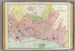
Montreal.
1 : 14000 Rand McNally and Company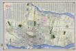
Shell Street Map of Montreal.
1 : 38016 Shell Oil Company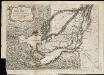
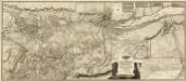
The Isles of Montreal as they have been survey'd by the French engineers
1 : 170000
Montreal.
Rand McNally and Company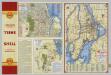
Downtown Montreal. Seeing Montreal. Shell Metropolitan District of Montreal.
Shell Oil Company
(This Topographical map of the Province of Lower Canada. Sheet) A.
1 : 174240 Faden, William, 1750?-1836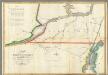
Map of the River St Lawrence and Adjacent Country.
1 : 291456 Melish, John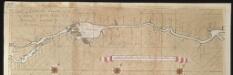
La riviere de Canada ou de St. Laurens de Quebec jusqu'à I. de Montreal aux Nord de l'Amérique
Canada Gerard van Keulen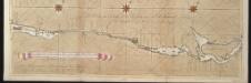
La riviere de Canada ou de St. Laurens de I. de Montreal jusqu'à le lac Ontario aux Nord de l'Amérique
Canada Gerard van Keulen
Shell Highway Map of New Hampshire, Vermont.
1 : 570240 Shell Oil Company
Survey of the several routes for a rail road from Ogdensburgh to Lake Champlain : made in pursuance of an act of the State of New York, passed May 14th, 1840 / by Edw H. Brodhead, chief engineer ; J.H. Jackson, H. Thomas & V. Whitney, commissrs.
from (A-Z)
Seat of War in Lower Canada.
1 : 443520 Lay, Amos
Vermont : from actual survey
1 : 700000 Doolittle, Amos, 1754-1832 Mathew Carey
Vermont and New Hampshire.
from Supplement to the New York observer.
Map exhibiting the Farmington & Hampshire & Hampden canals : together wth the line of their proposed continuation through the valley of the Connecticut River to Canada / engraved and published by N. & S.S. Jocelyn.
from Parts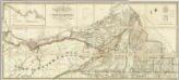
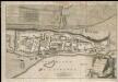
Map of the District Of Montreal, Lower Canada.
1 : 174240 Wyld, James, 1812-1887
New Hampshire and Vermont.
from New general atlas.
Lower Canada.
1 : 1520640 Burr, David H., 1803-1875
East Part of Canada.
1 : 1440000 Greenleaf, Jeremiah
Lower Canada.
1 : 1440000 Greenleaf, Jeremiah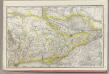
Ontario No. 2.
1 : 1110000 Rand McNally and Company
Post route map of the states of New Hampshire, Vermont, Massachusetts, Rhode Island, Connecticut, and parts of New York and Maine
1 : 380160 Nicholson, Walter L. United States. Post Office Dept.
Post route map of the states of New Hampshire, Vermont, Massachusetts, Rhode Island, Connecticut, and parts of New York and Maine
1 : 380160 Nicholson, W. L. United States. Post Office Dept.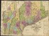
Map of Maine, New Hampshire and Vermont, from the most authentic sources
1 : 1350000 Brown and Parsons
(Canada, Louisiane et Terres Angloises. Southeast section) Le Fleuve Saint-Laurent.
1 : 910000 Anville, Jean Baptiste Bourguignon d, 1697-1782
Theatre des Operations de L'Armee du Nord, et Desert que le General Arnold.
1 : 2000000 Marshall, John
A new and accurate map of the province of New York and part of the Jerseys, New England and Canada, shewing the scenes of our military operations during the present war, also the new erected state of Vermont

Schonberg's Map of Canada East.
1 : 1939000 Schonberg & Co.