Maps of Cambridge

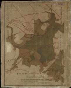
A plan of those parts of Boston, and the towns in its vicinity, with the waters and flats adjacent, which are immediately or remotely connected with the contemplated design of erecting perpetual tide-mills

A plan of those parts of Boston and the towns in its vicinity : with the waters and flats adjacent which are immediately or remotely connected with the contemplated design of erecting perpetual tide-mills
1 : 15840 Dearborn, Benjamin, 1754-1838 Benjamin Dearborn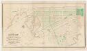
Plan of lands on the Back Bay : belonging to the Boston Water Power Co., the Commonwealth, and other parties, showing the system of streets & grades as laid out and recommended by the Back Bay Commissioners
1 : 3600 Boston (Mass.). Back Bay Commissioners A. Meisel, lith.
Plan of Boston comprising a part of Charlestown and Cambridge
1 : 7310 Smith, George Girdler, 1795-1878 George G. Smith
Plan of Boston comprising a part of Charlestown and Cambridge
1 : 7380 Smith, George Girdler, 1795-1878 George G. Smith
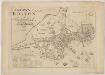
Plan of Boston comprising a part of Charlestown and Cambridgeport
1 : 6090 Fuller, Stephen P Annin & Smith ; J.V.N. Throop
Plan of Boston comprising a part of Charlestown and Cambridge
1 : 7310 Smith, George Girdler, 1795-1878 George G. Smith
An accurate plan of the town of Boston and its vicinity : exhibiting a ground plan of all the streets, lanes, alleys, wharves, and public buildings in Boston, with the names and description thereof, likewise all the flats and channels between Boston and Charlestown, Cambridge, Roxbury & Dorchester with the two bridges and causeway, and the boundary lines beween Boston and the above mentioned towns from ...
1 : 4170 Carleton, Osgood, 1742-1816 Published and sold by Osgood Carleton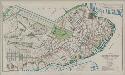
Plan of Boston proper : showing changes in street and wharf lines, 1795 to 1895
1 : 4800 Perkins, Charles Carroll H.H. Lloyd
Boston: Bird's-eye view from the North
Bachmann, John L. Prang & Co.
A map of the city of Boston in Massachusetts
1 : 7920 Bookshop for Boys and Girls (Boston, Mass.)
Boston, Birthplace of the Telephone : A Pictorial Map of the Down Town Area
Chase, Ernest Dudley, 1878-1966
To His Excellency William Burnet, Esqr. This Plan of Boston in New England...
The town of Boston in New England
1 : 5600 Bonner, John, ca. 1643-1726 George G. Smith
A rough and innacurate sketch of the streets of Boston as they are supposed to have been first laid out & the owners of the soil, from 1630 to 1650 or thereabouts

Plan of Boston
Mitchell, Samuel Augustus Jr.
This plan drawn from a scale of 200 ft. to an in. : [Cambridgeport, Massachusetts]
1 : 2400 Tufts, Peter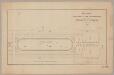
Part of a plan presented to the Commissioners for the improvement of the Back Bay
1 : 2400 T. & J. Doane (Firm) s.n.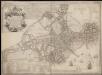
A new plan of ye great town of Boston in New England in America, with the many additionall buildings & new streets to the year 1743
1. Ward 4.
1 : 1200 Bromley, George Washington; Bromley, Walter Scott
An Plan of Boston in 1722
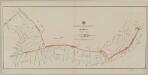
Plan showing proposed route of subway
1 : 2400 Boston (Mass.). Transit Commission L.H. Bradford & Co.'s, lith.
Plan of Boston showing existing ways and owners on December 25, 1645

Plan of Boston showing existing ways and owners on December 25, 1640

Plan of Boston showing existing ways and owners on December 25, 1635

Plan of the village in old Cambridge
1 : 1200 Wadsworth, Alexander, 1806-1898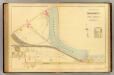
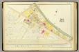
34. Ward 25 Brighton.
1 : 2400 Richards, L. J.
Plan of Boston
1 : 9320 Edward Cotton
A plan of Boston : from an actual survey ... 1796
1 : 9320 Carleton, Osgood, 1742-1816 John West
A plan of Boston, from actual survey